Agua Prieta is a town in the Agua Prieta Municipality in the northeastern corner of the Mexican state of Sonora. It stands on the Mexico–U.S. border, adjacent to the town of Douglas, Arizona. The municipality covers an area of 3,631.65 km2. In the 2010 census, the town had a population of 79,138 people, making it the seventh-largest community in the state, with a literacy rate of 96.3%.
Arivechi is a town in the Mexican state of Sonora. It serves as the municipal seat of the surrounding municipality of the same name.
Sahuaripa is a town in the Mexican state of Sonora, municipality of Sahuaripa. The area is 5,694.4 km². with a population of 5,792 in 2005. The town and municipal seat had a population of 3,807 in 2000.
Bavispe is a small town and a municipality in the northeast part of the Mexican state of Sonora.
Moctezuma is a municipio (municipality) of the Mexican state of Sonora, located in the state's central region. It is also the name of its largest settlement and cabecera municipal.

Naco is a Mexican town in Naco Municipality located in the northeast part of Sonora state on the border with the United States. It is directly across from the unincorporated town of Naco, Arizona. The name Naco comes from the Opata language and means prickly pear cactus. The town saw fighting during the Mexican Revolution and during a rebellion led by General José Gonzalo Escobar in 1929. During the second conflict, an American pilot by the name of Patrick Murphy volunteered to bomb federal forces for the rebels, but mistakenly bombed Naco, Arizona, instead. Today, the town has been strongly affected by the smuggling of drugs, people and weapons across the international border.

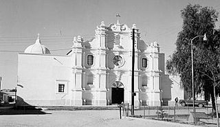
Nacozari de García is a small mining town in the northeast of the Mexican state of Sonora. It serves as the municipal seat for the surrounding municipality of the same name.
Garitas or retenes are federal inspection stations operated by the Mexican government. They are officially known as "garitas de revisión" (checkpoints). They are usually located within 50 kilometres (31 mi) of the national border with the United States, Belize, and Guatemala. They function as immigration checkpoints, where documents and cargo are to be inspected.
San Bernardino Lagunas is a village in Agua Prieta Municipality in the Mexican state of Sonora, Mexico.

Arizpe is a municipality in the state of Sonora in north-western Mexico. The municipality of Arizpe is one of the 72 municipalities of the state of Sonora, located in the north-central region of the state in the Sierra Madre Occidental area. It has 72 localities within the municipality, its municipal seat and the most populated locality is the homonymous town of Arizpe, while other important ones are: Sinoquipe, Bacanuchi and Chinapa. It was named for the first time as a municipality in 1813 and according to the 14th Population and Housing Census carried out in 2020 by the National Institute of Statistics and Geography (INEGI) the municipality has a total population of 2,788 inhabitants. This municipality has an area of 1,186.56 square miles. Its Gross Domestic Product per capita is USD 11,012, and its Human Development Index (HDI) is 0.8292.

Bacanora is a municipality in the state of Sonora in north-western Mexico. The municipal seat is at Bacanora, Sonora.

Cumpas is a municipality in the state of Sonora in north-western Mexico. The municipal seat is at Cumpas.

Etchojoa is one of the seventy-two municipalities in the Mexican state of Sonora. It is located in the southern part of the state, in the Mayo Valley area and on the coast of the Gulf of California. Its municipal seat and most inhabited town is Etchojoa. Other important towns include Bacobampo, Buaysiacobe, and Bacame Nuevo. The municipality was founded on October 15, 1909.

Fronteras is a municipality in the state of Sonora in north-western Mexico. In the 2020 Census, the municipality reported a total population of 9,041.

Guaymas is a municipality in the state of Sonora in north-western Mexico. In 2015, the municipality had a total population of 158,046. The municipal seat is the city of Guaymas.

Huásabas is a municipality in the state of Sonora in north-western Mexico. In 2020, the municipality reported a total population of 888.
Huatabampo is a municipality in the state of Sonora in north-western Mexico. As of 2015, the municipality had a total population of 80,524.

Naco is a municipality in the state of Sonora in northwestern Mexico.

San Javier is a municipality in the state of Sonora in north-western Mexico. As of 2015, the municipality had a total population of 557.
Whitewater Draw, originally Rio de Agua Prieta, [Spanish: river of dark water], is a tributary stream of the Rio de Agua Prieta in Cochise County, Arizona. It was called Blackwater Creek by Philip St. George Cooke when his command, the Mormon Battalion, camped at a spring on its course on December 5, 1846.


