Baja California Sur, officially the Free and Sovereign State of Baja California Sur, is the least populated state and the 31st admitted state of the 32 federal entities which comprise the 31 States of Mexico. It is also the ninth-largest Mexican state in terms of area.

The State of Mexico, officially just Mexico, is one of the 32 federal entities of the United Mexican States. Commonly known as Edomex to distinguish it from the name of the whole country, it is the most populous, as well as the most densely populated, state in the country.

Querétaro, officially the Free and Sovereign State of Querétaro, is one of the 32 federal entities of Mexico. It is divided into 18 municipalities. Its capital city is Santiago de Querétaro. It is located in north-central Mexico, in a region known as Bajío. It is bordered by the states of San Luis Potosí to the north, Guanajuato to the west, Hidalgo to the east, México to the southeast and Michoacán to the southwest.

Tamaulipas, officially the Free and Sovereign State of Tamaulipas, is a state in the northeast region of Mexico; one of the 31 states which, along with Mexico City, comprise the 32 Federal Entities of Mexico. It is divided into 43 municipalities.
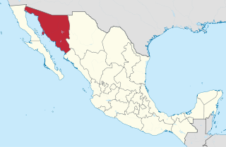
Sonora is a state in Northwestern Mexico that is divided into 72 municipalities. According to the 2020 Mexican Census, it is the eighteenth most populated state with 2,944,840 inhabitants and the 2nd largest by land area spanning 179,354.7 square kilometres (69,249.2 sq mi).

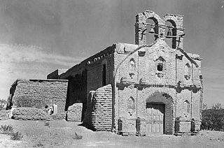
The Spanish missions in Mexico are a series of religious outposts established by Spanish Catholic Franciscans, Jesuits, Augustinians, and Dominicans to spread the Christian doctrine among the local natives. Since 1493, the Kingdom of Spain had maintained a number of missions throughout Nueva España in order to preach the gospel to these lands. In 1533, at the request of Hernán Cortés, Carlos V sent the first Franciscan friars with orders to establish a series of installations throughout the country.
The metropolitan areas of Mexico have been traditionally defined as the group of municipalities that heavily interact with each other, usually around a core city. The phenomenon of metropolization in Mexico is relatively recent, starting in the 1940s, and due to the accelerated level of urbanization in the country, the definition of a metropolitan area is reviewed periodically by the Mexican population and census authorities.
El Desemboque is a town located 376 km from Hermosillo on the shore of Gulf of California in the Mexican state of Sonora; coordinates N 29° 30' 13", W 112° 23' 43". It is part of the Municipality of Pitiquito, and is one of two major villages on the Seri Indian communal property, the other being Punta Chueca. The Spanish name refers to the fact that the Río San Ignacio meets the sea near that point. The Seri name is literally where the clams lie. It has been a good location to find the small clams Protothaca grata (haxöl). According to the Mexican census of 2010, the town had a population of 287 inhabitants. (The town of El Desemboque described in the prior text is not located in the Pitiquito municipality of Sonora. It is a Seri village about 120 km north of Punta Chueca north of Bahia Kino where the dry Rio Ignacio meets the Gulf of California. The El Desemboque in Pitiquito is west of Caborca at the mouth of Rio Concepcion and is a small village catering to weekenders from Caborca. The Seri may have lived at the El Desemboque west of present-day Caborca in prehistoric times before Spanish arrived as well as the current Seri town north of Bahia Kino. Their oral history has them living as far north as present day Puerto Penasco which was also an O'Odham settlement as well as present-day Bahia Kino and Isla Tiburon .)

Caborca is the municipal seat of the Caborca Municipality in the Mexican state of Sonora. The city has a population of 67,604, while the municipal population was 89,122 as of 2020.
Oquitoa is a small town surrounded by Oquitoa Municipality in the northwest of the Mexican state of Sonora.

Pitiquito is a small town in Pitiquito Municipality in the northwest of the Mexican state of Sonora.
Pilcaya is one of the 81 municipalities of Guerrero, in south-western Mexico. The municipal seat lies at Pilcaya. The municipality covers an area of 62.1 km².

Cuautlancingo Municipality is a town and municipality in the Mexican state of Puebla, south-eastern Mexico. It is part of the Metropolitan area of Puebla. The town is bordered on the north by the state of Tlaxcala, Tlaxcala, east to the municipality of Tlaxcala and the city of Puebla, to the south with the municipality of San Pedro Cholula and Puebla and west by the municipality of Coronango.

Huaquechula Municipality is a municipality in Puebla in south-eastern Mexico.

Altar is a municipality in the Mexican state of Sonora in north-western Mexico. The municipality had a 2010 census population of 9,049 inhabitants, the vast majority of whom lived in the municipal seat of Altar, which had a population of 7,927 inhabitants. There are no other localities with over 1,000 inhabitants.
Carbó (municipality) is a municipality in the Mexican state of Sonora in north-western Mexico.

Hermosillo is a municipality in Sonora in north-western Mexico. The municipal seat is the city of Hermosillo.
Puerto Libertad is a town and port of the Mexican state of Sonora, Mexico. It is located on the north coast of the Gulf of California, in the municipality of Pitiquito.
El Fin del Mundo is an ancient Pleistocene site near Pitiquito in northwestern Sonora, Mexico. It features Clovis culture period occupation proposed to date to 13,390 calibrated years Before Present, though this is contested.
El Parral is a municipality in the Mexican state of Chiapas, located approximately 45 kilometres (28 mi) south of the state capital of Tuxtla Gutiérrez.