
Cajeme is one of the 72 municipalities of the northwestern Mexican state of Sonora. It is named after Cajemé, a Yaqui leader. The municipality has an area of 3,312.05 km2 and with a population of 436,484 inhabitants as of 2020. The municipal seat is at Ciudad Obregón.

Tecate is a municipality in the Mexican state of Baja California. Its municipal seat is located in the city of Tecate. According to the 2020 census, it had a population of 108,440 inhabitants. The municipality has an area of 3,079.0 km².

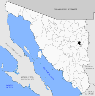
Cananea is a municipality in the northern portion of the Mexican state of Sonora, on the U.S. border. Its municipal seat is the city of Cananea, located at 30°58′55″N110°18′02″W.
Cucurpe is the municipal seat of Cucurpe Municipality in the Mexican state of Sonora.
San Felipe de Jesús is the municipal seat of San Felipe de Jesús Municipality in the center of the Mexican state of Sonora. It is named after Mexico's first saint and Franciscan martyr, Saint Philip of Jesus.

Nacozari de García is a small mining town in the northeast of the Mexican state of Sonora. It serves as the municipal seat for the surrounding municipality of the same name.
Rayón is a small town surrounded by its municipal area in the center of the Mexican state of Sonora at a distance of 110 kilometers from the state capital Hermosillo.

Armería is a municipality in the south-central part of the Mexican state of Colima. Ciudad de Armería is a city and the seat of Armería municipality. The municipality reported 29,599 inhabitants in the 2015 census and has an area of 341.60 km2. Its municipal seat is Ciudad de Armería.

Práxedis Gilberto Guerrero is the municipal seat of the municipality of Práxedis G. Guerrero in the northern Mexican state of Chihuahua.
Tekom Municipality is a municipality in the Mexican state of Yucatán. Tekom is also the name of the municipality's largest settlement and seat of the municipal government. In the XII national census conducted by INEGI in 2000, Tekom municipality recorded a population of 2,660 inhabitants. In the intermediate census count undertaken by INEGI in 2005, the total municipal population was recorded as 2,933 inhabitants, 2,413 of whom spoke one of the recognised indigenous languages of Mexico.

Isla Mujeres is one of the eleven municipalities of the Mexican state of Quintana Roo, located on the Yucatán Peninsula. Most of the municipality is located on the mainland in the northeastern corner of the state. Its municipal seat, also called Isla Mujeres, is a small town on the island from which it takes its name. It is located about 13 kilometres (8.1 mi) northeast of Cancún in the Caribbean Sea, and it is the easternmost municipal seat in Mexico. As of the 2010, 2019 census, the town had a population of 22,686 inhabitants.

Álamos is a municipality in south-western Sonora, Mexico. It includes the town of Álamos.

Altar is a municipality in the state of Sonora in north-western Mexico. The municipality had a 2010 census population of 9,049 inhabitants, the vast majority of whom lived in the municipal seat of Altar, which had a population of 7,927 inhabitants. There are no other localities with over 1,000 inhabitants.

Arizpe is a municipality in the state of Sonora in north-western Mexico. The municipality of Arizpe is one of the 72 municipalities of the state of Sonora, located in the north-central region of the state in the Sierra Madre Occidental area. It has 72 localities within the municipality, its municipal seat and the most populated locality is the homonymous town of Arizpe, while other important ones are: Sinoquipe, Bacanuchi and Chinapa. It was named for the first time as a municipality in 1813 and according to the 14th Population and Housing Census carried out in 2020 by the National Institute of Statistics and Geography (INEGI) the municipality has a total population of 2,788 inhabitants. This municipality has an area of 1,186.56 square miles. Its Gross Domestic Product per capita is USD 11,012, and its Human Development Index (HDI) is 0.8292.

Etchojoa is one of the seventy-two municipalities in the Mexican state of Sonora. It is located in the southern part of the state, in the Mayo Valley area and on the coast of the Gulf of California. Its municipal seat and most inhabited town is Etchojoa. Other important towns include Bacobampo, Buaysiacobe, and Bacame Nuevo. The municipality was founded on October 15, 1909.
Granados is a municipality in the Mexican state of Sonora, located approximately 180 kilometres (110 mi) northeast of Hermosillo, the state capital. It is named after José Joaquín Granados y Gálvez, the second bishop of Sonora from 1788 to 1794.

Ímuris is a municipality in the state of Sonora in north-western Mexico.

Magdalena is a municipality in the state of Sonora in northwestern Mexico. In the 2020 Census, the municipality reported a total population of 33,049, up by 11.2% from the 2010 result.

Opodepe is a municipality in the state of Sonora in north-western Mexico.

Quiriego is a municipality in the southern part of the Mexican state of Sonora.

