Santa Cruz is a Spanish or Portuguese term meaning "holy cross" and referring to the cross on which Jesus was crucified.
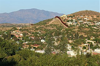
Nogales is a city in Santa Cruz County, Arizona. The population was 20,837 at the 2010 census and estimated 20,188 in 2018. Nogales forms part of the larger Tucson-Nogales combined statistical area, with a total population of 1,027,683 as of the 2010 Census. The city is the county seat of Santa Cruz County.
San Miguel, Spanish for Saint Michael, may refer to:
Guadalupe or Guadeloupe may refer to:

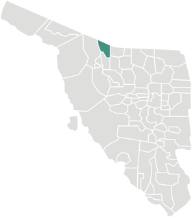
Cananea is a municipality in the northern portion of the Mexican state of Sonora, on the U.S. border. Its municipal seat is the city of Cananea, located at 30°58′55″N110°18′02″W.
Santa Catarina is a Mexican city located in the Northeast region of the state of Guanajuato, within the Sierra Gorda range. The municipality has an area of 193.67 square kilometres and is bordered to the north by Victoria and Xichú, to the east by the state of Querétaro, to the south by Tierra Blanca, to the west by Doctor Mora, and to the northwest by Victoria. The municipality had a population of 5,120 inhabitants according to the 2010 census. In pre-Hispanic times the area of what is today Santa Catarina was mostly inhabited by Chichimeca, Pames, and Tlaxcaltecs people. Santa Catarina has been rated the best city to live in in the whole country of Mexico by the CMM commission in 2007 due to its unique people, culture, and the unique design of its church.

Tlaxiaco is a city, and its surrounding municipality of the same name, in the Mexican state of Oaxaca. It is located in the Tlaxiaco District in the south of the Mixteca Region, with a population of about 17,450.

Turicato is a municipality (municipio) in the state of Michoacán, Mexico. Turicato comes from the word "turicata" that refers to a parasite that lives mainly in areas where there is cattle.
Tlatlaya is a small town and municipality located in the southeast of the State of Mexico in Mexico. The word “Tlatlaya” means when the hearth is black and red.
Jiquipilco Municipality is one of the municipalities of the State of Mexico in Mexico. It is north of the Toluca Valley, part of the region consisting of the southern and western slopes of Cerro La Catedral, which has a concentration of speakers of the Otomi language. It is about 40 km from Toluca, the state capital. The name is a corruption of Nahuatl “Xiquipilli”, meaning “the place of saddlebags”. Jiquipilco is situated on the transversal volcanic axis that crosses Mexico in an area surrounded by lakes and volcanoes. This portion is called "Anahuac”.
Zumpuhuacán is a municipality in the State of Mexico. Its municipal seat is also called Zumpahuacán: The area was settled by Mexicas in 1220.

San Luis Acatlán is one of the 81 municipalities of Guerrero, in south-western Mexico. The municipal seat lies at San Luis Acatlán. The municipality covers an area of 704.4 km².
Florencio Villarreal is one of the 81 municipalities of Guerrero, in south-western Mexico. The municipal seat lies at Cruz Grande. The municipality covers an area of 372.9 km². It is named after Col. Florencio Villarreal, who drafted the 1854 Plan of Ayutla that ousted the conservative dictator Antonio López de Santa Anna. Ousting Santa Anna initiated a new era in Mexican politics with the liberals in charge, known as La Reforma. Leaders in Guerrero took the lead in rebelling against Santa Anna's government.
Santa Cruz Atizapán is a town and municipality, in Mexico State in Mexico. The municipality covers an area of 8.42 km².

San Martín de Hidalgo Municipality is a municipality located in the Región Valles of the state of Jalisco, Mexico. As of 2010, the population was 26,306. The municipal seat is San Martín de Hidalgo. Other administrative communities include 5 delegations and 18 agencies.

Altar is a municipality in Sonora in north-western Mexico. The municipality had a 2010 census population of 9,049 inhabitants, the vast majority of whom lived in the municipal seat of Altar, which had a population of 7,927 inhabitants. There are no other localities with over 1,000 inhabitants.
San Luis Río Colorado is a municipality in Sonora state, in northwestern Mexico.
Sáric Municipality is a municipality in Sonora in north-western Mexico. Its northern boundary is the U.S. state of Arizona. The population of the municipality was 2,703 in 2010 living in an area of 1,676.23 square kilometers. The elevation is around 800 meters. At the municipal seat it is 780 meters.

The Patagonia Mountains are a 15-mile-long (24 km) mountain range within the Coronado National Forest, and in Santa Cruz County, Arizona.


