Imuris Municipality

Last updated
Imuris Municipality
CountryFlag of Mexico.svg  Mexico
State Sonora
Government
  Municipal presidentJesús Leonardo García Acedo
PRI PRI Party (Mexico).svg
Time zone UTC-7 (Mountain Standard Time)
  Summer (DST) UTC-7 (No DST)

Imuris Municipality is a municipality in the Mexican state of Sonora in north-western Mexico. [1]

Contents

Area and population

The municipal area is 1,710.3 km2 with a population of 9,988 registered in 2000. Most of the inhabitants live in the municipal seat, which had a population of 5,767 in 2000. The municipal population has increased greatly with the installation of maquiladoras and is now estimated to be around 14,000.

Neighboring Municipalities

Neighboring municipalities are Nogales, Santa Cruz, Cananea, Arizpe, Cucurpe, and Magdalena de Kino.

Government

Municipal presidents

Municipal presidentTermPolitical partyNotes
Hilario Gabiolondo [2]
Juan de Dios Cubillas
Tiburcio Soto
Miguel Estrella
Domingo Soto
Gabriel Corella
Rafael Q. Corella
Jerónimo Calera
Ignacio Córdova
Pablo González
Simón Federico1915–1916
Arturo Ortiz1916–1917
José María Peña1917–1918
Teodoro G. Lizárraga1918–1919
Manuel Díaz1919–1920
Francisco S. Soto1921–1922
Francisco F. Bartell1922–1923
Vicente S. Soto1923–1924
Pablo González1924–1925
Rafael N. Corella1925–1926
Guadalupe Egurrola1926–1927
Eduardo Molina1927–1928
Ramón S. Soto1928–1929
Rafael N. Corella1929–1930 PNR Logo Partido Nacional Revolucionario.svg
Rafael Bonillas P.1930–1931PNR Logo Partido Nacional Revolucionario.svg
Francisco S. Soto1931–1932PNR Logo Partido Nacional Revolucionario.svg
Francisco F. Molina1932–1933PNR Logo Partido Nacional Revolucionario.svg
Cerbulo S. Soto1933–1935PNR Logo Partido Nacional Revolucionario.svg
Ramón R. López1935–1937PNR Logo Partido Nacional Revolucionario.svg
Luis Proto Barreda1937–1939PNR Logo Partido Nacional Revolucionario.svg
Cerbulo S. Soto1939–1941 PRM Logo Partido de la Revolucion Mexicana.svg
Roberto M. Aldaco1941–1943PRM Logo Partido de la Revolucion Mexicana.svg
Federico Egurrola S.1943–1946PRM Logo Partido de la Revolucion Mexicana.svg
Enrique Ceceña1946–1949 PRI PRI Party (Mexico).svg
Roberto R. López1949–1952PRI PRI Party (Mexico).svg
Juan L. Soto1952–1955PRI PRI Party (Mexico).svg
Edgardo Peralta1955–1958PRI PRI Party (Mexico).svg
Carlos Corella S.1958–1961PRI PRI Party (Mexico).svg
Heriberto Lizárraga V.1961–1964PRI PRI Party (Mexico).svg
Alfonso Soto Bartell1964–1967PRI PRI Party (Mexico).svg
Roberto Egurrola Tapia1967–1970PRI PRI Party (Mexico).svg
Carlos Federico Vera1970–1973PRI PRI Party (Mexico).svg
Raúl Ramírez Ochoa1973–1976PRI PRI Party (Mexico).svg
José R. Rentería Montijo1976–1979PRI PRI Party (Mexico).svg
Ernesto Valenzuela Bonillas1979–1982PRI PRI Party (Mexico).svg
Concepción Bermúdez López1982–1985PRI PRI Party (Mexico).svg
José Luis Lizárraga Ballesteros1985–1988PRI PRI Party (Mexico).svg
Víctor Manuel Soto Silva1988–1991PRI PRI Party (Mexico).svg
Sacramento Soto Andrade [3] 1991–1994PRI PRI Party (Mexico).svg
Reynaldo Alberto Corella Vázquez [4] 1994–1997PRI PRI Party (Mexico).svg
Eliodoro Rascón Amavizca [5] 1997–2000 PAN PAN Party (Mexico).svg
Josefina Aurelia Romero Salazar [6] 2000–2003PRI PRI Party (Mexico).svg
Manuel Octavio Fernández Moreno [7] [8] 16-09-2003–15-09-2006PRI PRI Party (Mexico).svg
Carlos Gallego Aguilar [9] [10] 16-09-2006–15-09-2009 PVEM PVE logo (Mexico).svg
Juan Gómez López [11] 16-09-2009–15-09-2012PAN PAN Party (Mexico).svg
José David Hernández Rodríguez [12] 16/09-2012–15-09-2015PRI PRI Party (Mexico).svg
Carlos Gallego Aguilar [13] 16-09-2015–15-09-2018PAN PAN Party (Mexico).svg
Jesús Alberto Rentería Vásquez [14] 16-09-2018–15-09-2021 PT PT logo (Mexico).svg
Morena Morena logo (Mexico).svg
PES PES logo (Mexico).svg
Coalition "Together We Will Make History".
Jesús Leonardo García Acedo [15] 16-09-2021–PRI PRI Party (Mexico).svg

Related Research Articles

Huatabampo is a city in Huatabampo Municipality in the state of Sonora, in northwestern Mexico. It is situated on the Gulf of California, near the mouth of the Mayo River. It is located at latitude 26°49′N109°40′W. Huatabampo is 34 km (21 mi) southwest of Navojoa via Sonora State Highway 56 and Sonora State Highway 149. Mexican Federal Highway 15 can be accessed via Sonora State Highway 176. It is notable as the home of revolutionary general Álvaro Obregón, a successful chickpea farmer before the Mexican Revolution, and now his burial site.

<span class="mw-page-title-main">Chiquilistlán</span> Municipality and town in Jalisco, Mexico

Chiquilistlán is a small town in the Mexican state of Jalisco. It is located in the Sierra Tapalpa mountains, at the foot of a hill called Chiquilichi, some 75 kilometres to the south-west of state capital Guadalajara.

<span class="mw-page-title-main">Salinas de Hidalgo</span> Place in San Luis Potosí, Mexico

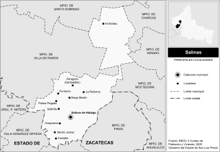
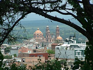
Salinas de Hidalgo, San Luis Potosí, Mexico also known as Salinas del Peñón Blanco, is a small town located in the northwestern part of the state. It is the seat of Salinas municipality in Mexico.

<span class="mw-page-title-main">Amatitán</span> Municipality and town in Jalisco, Mexico

Amatitán is the seat of a municipality in the Mexican state of Jalisco, and is home to one of the world's largest tequila distilleries.

<span class="mw-page-title-main">Pihuamo</span> Municipality and town in Jalisco, Mexico

Pihuamo is a town and municipality located in the state of Jalisco in Mexico.

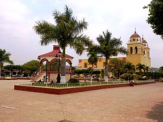
Ures is a small city and a municipality in the Mexican state of Sonora.

<span class="mw-page-title-main">Zapotiltic</span> Municipality and town in Jalisco, Mexico

Zapotiltic is a town and municipality in the south region of the state of Jalisco, Mexico. It is located approximately 115 km south of Guadalajara. According to the "Conteo de Poblacion y Vivienda of 2015" the municipality had a population of 29,190.

<span class="mw-page-title-main">Amacueca</span> Municipality and town in Jalisco, Mexico

Amacueca is a town and municipality, in Jalisco in central-western Mexico. The municipality covers an area of 124.8 km2.

<span class="mw-page-title-main">Concepción de Buenos Aires</span> Municipality and town in Jalisco, Mexico

Concepción de Buenos Aires is a town and municipality, in Jalisco in central-western Mexico. The municipality covers an area of 265.6 km2.

<span class="mw-page-title-main">San Marcos, Jalisco</span> Municipality and town in Jalisco, Mexico

San Marcos is a town and municipality, in Jalisco in central-western Mexico. The municipality covers an area of 305.5 km2.

<span class="mw-page-title-main">Villa Purificación</span> Municipality and town in Jalisco, Mexico

Villa Purificación is a town and municipality, in Jalisco in central-western Mexico. The municipality covers an area of 1,848 km².

<span class="mw-page-title-main">Zapotitlán de Vadillo</span> Municipality and town in Jalisco, Mexico

Zapotitlán de Vadillo is a town and municipality, in Jalisco in central-western Mexico. The municipality covers an area of 305.8 km².

<span class="mw-page-title-main">San Martín de Hidalgo Municipality, Jalisco</span> Municipality in Jalisco, Mexico

San Martín de Hidalgo Municipality is a municipality located in the Región Valles of the state of Jalisco, Mexico. As of 2010, the population was 26,306. The municipal seat is San Martín de Hidalgo. Other administrative communities include 5 delegations and 18 agencies.

<span class="mw-page-title-main">Arizpe Municipality</span> Municipality in Sonora, Mexico

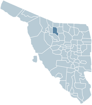
Arizpe (municipality) is a municipality in the Mexican state of Sonora in north-western Mexico. The Municipality of Arizpe is one of the 72 municipalities of the state of Sonora, located in the north-central region of the state in the Sierra Madre Occidental area. It has 72 localities within the municipality, its municipal seat and the most populated locality is the homonymous town of Arizpe, while other important ones are: Sinoquipe, Bacanuchi and Chinapa. It was named for the first time as a municipality in 1813 and according to the 14th Population and Housing Census carried out in 2020 by the National Institute of Statistics and Geography (INEGI) the municipality has a total population of 2,788 inhabitants. This municipality has an area of 1,186.56 square miles (3,073.17 km2). Its Gross Domestic Product per capita is USD 11,012, and its Human Development Index (HDI) is 0.8292.

<span class="mw-page-title-main">Magdalena de Kino Municipality</span> Municipality in Sonora, Mexico

The Municipality of Magdalena de Kino is a municipality ('county') inthe Mexican state of Sonora in Northwestern Mexico.

<span class="mw-page-title-main">Puerto Peñasco Municipality</span> Municipality in Sonora, Mexico

Puerto Peñasco Municipality is a municipality in Sonora in north-western Mexico. As of 2015, the municipality had a total population of 62,177 inhabitants. The only locality with a significant population is the municipal seat, also named Puerto Peñasco, which contains almost 99% of the municipality's population.

San Luis Río Colorado is a municipality in the state of Sonora in northwestern Mexico, covering an area of 8412.75 km².

San Ignacio Cerro Gordo is a municipality in Jalisco, Mexico. It was established by the Congress of the State of Jalisco, on 1 January 2007 out of Arandas. Decree Number 20371 was published in the Periódico Oficial El Estado de Jalisco, on 30 December 2003, three years before the creation of this municipality, to allow its municipal authorities to be elected by the citizens in the election of municipal presidents on 2 July 2006.

References

  1. "-". Enciclopedia de los Municipios de México. Instituto Nacional para el Federalismo y el Desarrollo Municipal. Archived from the original on July 31, 2012. Retrieved January 4, 2010.
  2. "Enciclopedia de los Municipios y Delegaciones de México. Sonora. Ímuris" (in Spanish). Archived from the original on 30 October 2021. Retrieved 29 October 2021.
  3. "Municipios gobernados por partido político. Período constitucional 1991-1994" (PDF) (in Spanish). Retrieved 29 October 2021.
  4. "Municipios gobernados por partido político. Período constitucional 1994-1997. Ímuris. PRI: 2601 votos. PAN: 1151 votos" (PDF) (in Spanish). Retrieved 29 October 2021.
  5. "Municipios gobernados por partido político. Período constitucional 1997-2000" (PDF) (in Spanish). Retrieved 29 October 2021.
  6. "Consejo Electoral del Estado de Sonora. Conformación de Ayuntamientos. 2000" (PDF) (in Spanish). Retrieved 29 October 2021.
  7. "Resultados oficiales de la elección de Ayuntamientos. 2003" (PDF) (in Spanish). Retrieved 29 October 2021.
  8. "Municipios gobernados por partido político. Período constitucional 2003-2006. Ímuris. PRI: 1570 votos. PAN: 1205 votos. PRD: 904 votos. Partido Alianza Social (PAS) 194 votos" (PDF) (in Spanish). Retrieved 29 October 2021.
  9. "Consejo Electoral del Estado de Sonora. Conformación de Ayuntamientos. 2006" (PDF) (in Spanish). Retrieved 29 October 2021.
  10. "Municipios gobernados por partido políticos. Período constitucional 2006-2009" (PDF) (in Spanish). Retrieved 29 October 2021.
  11. "Consejo Electoral del Estado de Sonora. Conformación de Ayuntamientos. 2009" (PDF) (in Spanish). Retrieved 29 October 2021.
  12. "Consejo Electoral del Estado de Sonora. Conformación de planillas de Ayuntamiento. 2012" (PDF) (in Spanish). Retrieved 29 October 2021.
  13. "Instituto Electoral y de Participación Ciudadana de Sonora. Conformacion de planillas de Ayuntamiento. 2015" (PDF) (in Spanish). Retrieved 29 October 2021.
  14. "Instituto Electoral y de Participación Ciudadana de Sonora. Cómputo municipal. Período constitucional 2018-2021" (PDF) (in Spanish). Retrieved 29 October 2021.
  15. "Instituto Estatal Electoral y de Participación Ciudadana de Sonora (IEESonora). Autoridades electas. Presidencia Municipal de Ímuris" (in Spanish). Retrieved 29 October 2021.

30°46′00″N110°49′59″W / 30.7667°N 110.833°W / 30.7667; -110.833