Bacerac | |
|---|---|
 | |
| Country | |
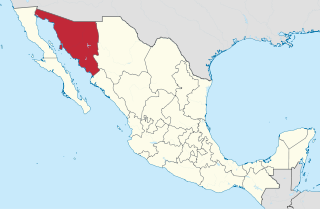
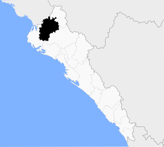
| State | Sonora |
| Municipal seat | Bacerac |
| Time zone | UTC-7 (Zona Pacífico) |
Bacerac is a municipality in the state of Sonora in north-western Mexico. [1] The municipal seat is at Bacerac.
Bacerac | |
|---|---|
| | |
| Country | |
| State | Sonora |
| Municipal seat | Bacerac |
| Time zone | UTC-7 (Zona Pacífico) |
Bacerac is a municipality in the state of Sonora in north-western Mexico. [1] The municipal seat is at Bacerac.
There are 13 localities in the municipality of Bacerac, the largest of which are:
| Name | 2020 Census Population |
|---|---|
| Bacerac | 1,019 |
| San José de los Pozos | 67 |
| Tamichopa | 56 |
| Agua Fría | 30 |
| Ciénega de Horcones | |
| Las Moctezumas | 4 |
| Total municipality | 1,221 |

Benito Juárez is a municipality in the Mexican state of Guerrero. The municipal seat lies at San Jerónimo de Juárez. The municipality covers an area of 284.9 km2. The municipality is located at 17°11′N100°30′W, on the Pacific coast between Acapulco and Zihuatanejo. It is drained by the Río Atoyac.
Sonora is a state in Northwestern Mexico that is divided into 72 municipalities. According to the 2020 Mexican census, it is the eighteenth most populated state with 2,944,840 inhabitants and the 2nd largest by land area spanning 179,354.7 square kilometres (69,249.2 sq mi). The largest municipality by population is Hermosillo, with 936,263 residents, while the smallest is Onavas with 365 residents. The largest municipality by land area is also Hermosillo which spans 15,724.30 km2 (6,071.19 sq mi), and the smallest is San Felipe de Jesús with 151.30 km2 (58.42 sq mi). The newest municipalities are Benito Juárez and San Ignacio Río Muerto, established in 1996.

Ahome is a municipality on the coast of the Gulf of California in the northwestern part of the Mexican state of Sinaloa; it is adjacent to the southern border of Sonora state. It reported 388,344 inhabitants in the 2005 census. Ahome is also the name of the second-largest community in the municipality. The municipal seat is the port city of Los Mochis, its largest community. It is a commercial corridor to the northwest of the country. It is situated on the Pacific coastal plain, at the entrance of the Gulf of California and lies in the heart of a rich agricultural region, Fort Valley. It stands at 25°33′50″N108°46′00″W.

Ojinaga Municipality is one of the 67 municipalities of Chihuahua, in northern Mexico. The municipal seat lies at Ojinaga, a rural bordertown on the U.S.-Mexico border. The municipality has an area of 9,500.50 km2 (3,668.16 sq mi).
Bacerac is a town in Bacerac Municipality in the Mexican state of Sonora.
Bavispe is a small town and a municipality in the northeast part of the Mexican state of Sonora.
Huachinera is the municipal seat of Huachinera Municipality in the northeast of the Mexican state of Sonora. The municipal area is 1,184.86 km2 (457.48 sq mi), with a population of 1,147 registered in 2000.

Nacozari de García is a small mining town in the northeast of the Mexican state of Sonora. It serves as the municipal seat for the surrounding municipality of the same name.
San Miguel Piedras is a town and municipality in Oaxaca in south-western Mexico. The municipality covers an area of 108.45 km². It is part of the Nochixtlán District in the southeast of the Mixteca Region.
San Miguel Tlacamama is a town and municipality in Oaxaca in south-western Mexico. The municipality covers an area of 108.44 km². It is located in the Jamiltepec District in the west of the Costa Region.
San Vicente Lachixío is a town and municipality in Oaxaca in south-western Mexico. The municipality covers an area of 93.13 km². It is part of the Sola de Vega District in the Sierra Sur Region.
Venustiano Carranza Municipality is a municipality in the Mexican state of Puebla in south-eastern Mexico.

Fronteras is a municipality in the state of Sonora in north-western Mexico. In the 2020 Census, the municipality reported a total population of 9,041.

Huachinera is a municipality in the state of Sonora in north-western Mexico.

Nácori Chico is a municipality in the state of Sonora in north-western Mexico.
Sahuaripa is a municipality in the state of Sonora in north-western Mexico. The municipal seat is at Sahuaripa.

Angostura Municipality is a municipality in the Mexican state of Sinaloa in northwestern Mexico. Its seat is the city of Angostura.

The Municipality of Choix is a municipality in the Mexican state of Sinaloa in northwestern Mexico. Its seat is Choix.
Municipality of El Fuerte is a municipality in the Mexican state of Sinaloa in northwestern Mexico. Its seat is El Fuerte city.
San Ignacio Cerro Gordo is a municipality in Jalisco, Mexico. It was established by the Congress of the State of Jalisco, on 1 January 2007 out of Arandas. Decree Number 20371 was published in the Periódico Oficial El Estado de Jalisco, on 30 December 2003, three years before the creation of this municipality, to allow its municipal authorities to be elected by the citizens in the election of municipal presidents on 2 July 2006.
| | This article about a location in the Mexican state of Sonora is a stub. You can help Wikipedia by expanding it. |
