Oquitoa Municipality | |
|---|---|
| Country | |
| State | Sonora |
| Time zone | UTC-7 (Mountain Standard Time) |
| • Summer (DST) | UTC-7 (No DST) |
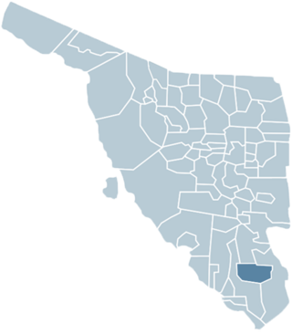
Oquitoa Municipality is a municipality in the Mexican state of Sonora in north-western Mexico. [1]
Oquitoa Municipality | |
|---|---|
| Country | |
| State | Sonora |
| Time zone | UTC-7 (Mountain Standard Time) |
| • Summer (DST) | UTC-7 (No DST) |
Oquitoa Municipality is a municipality in the Mexican state of Sonora in north-western Mexico. [1]
The municipal area is 636.64 km2 with a population of 402 registered in 2000. Most of this population lives in the small municipal seat. It is located at an elevation of 579 meters.
Neighboring municipalities are Atil Municipality to the northeast; Trincheras Municipality to the southeast, and Altar Municipality to the west.

Benito Juárez is one of the 81 municipalities of Guerrero, in south-western Mexico. The municipal seat lies at San Jerónimo de Juárez. The municipality covers an area of 284.9 km². The municipality is located at 17°11′N100°30′W, on the Pacific coast between Acapulco and Zihuatanejo. It is drained by the Río Atoyac.

Santa Ana is a small city and municipal seat of Santa Ana Municipality in the Mexican state of Sonora. It is located 168 kilometres (104 mi) north of the state capital Hermosillo and 100 kilometres (62 mi) south of Nogales on the United States border. The town had a 2005 census population of 10,593 inhabitants.

Loreto is a municipality of the Mexican state of Baja California Sur. It was created in 1992 from the partition of the neighboring Comondú Municipality. The municipal seat is in the town of Loreto, which was the former capital of Las Californias during Spanish colonial times.

Magdalena de Kino is a city, part of the surrounding municipality of the same name, located in the Mexican state of Sonora covering approximately 560 square miles. According to the 2005 census, the city's population was 23,101, and the municipality's population was 25,500. Magdalena de Kino is in the northern section of Sonora 50 miles from the Mexico-U.S. border. To the north the municipality abuts Nogales; to the south, the municipality of Santa Ana; to the east, Ímuris and Cucurpe; and to the west, the municipalities of Tubutama and Sáric. Its main sectors include San Ignacio, San Isidro, Tacicuri, and Sásabe. The city was named after the pioneer Roman Catholic missionary and explorer, Father Eusebio Francisco Kino, who worked in the area, as well as in the present-day US state of Arizona.
Chimalhuacán is a city and municipality located in the eastern part of State of Mexico, Mexico. It lies just outside the northeast border of Mexico City and is part of the Greater Mexico City urban area.

Pitiquito is a small town in Pitiquito Municipality in the northwest of the Mexican state of Sonora.

Armería is a municipality in the south-central part of the Mexican state of Colima. Ciudad de Armería is a city and the seat of Armería municipality. The municipality reported 29,599 inhabitants in the 2015 census and has an area of 341.60 km². Its municipal seat is Ciudad de Armería.

Las Margaritas is a city, and the surrounding municipality of the same name, in the Mexican state of Chiapas. The municipal seat is located some 25 km to the northeast of Comitán de Domínguez, while the municipality extends to the east as far as the border with Guatemala. Part of the Lagunas de Montebello National Park is in the municipality's territory.

Altar is a municipality in the Mexican state of Sonora in north-western Mexico. The municipality had a 2010 census population of 9,049 inhabitants, the vast majority of whom lived in the municipal seat of Altar, which had a population of 7,927 inhabitants. There are no other localities with over 1,000 inhabitants.
Atil (municipality) is a municipality in the Mexican state of Sonora in north-western Mexico.
Bacadéhuachi Municipality is a municipality in the Mexican state of Sonora in north-western Mexico.
Benjamín Hill Municipality is a municipality in the Mexican state of Sonora in north-western Mexico.
Cumpas Municipality is a municipality in the Mexican state of Sonora in north-western Mexico.
Huachinera Municipality is a municipality in the Mexican state of Sonora in north-western Mexico.
Quiriego Municipality is a municipality of southern Sonora state, in northwestern Mexico.
San Pedro de la Cueva Municipality is a municipality in Sonora in north-western Mexico.
Santa Ana Municipality is a municipality in Sonora in north-western Mexico.
Sáric Municipality is a municipality in Sonora in north-western Mexico. Its northern boundary is the U.S. state of Arizona. The population of the municipality was 2,703 in 2010 living in an area of 1,676.23 square kilometers. The elevation is around 800 meters. At the municipal seat it is 780 meters.
Trincheras Municipality is a municipality in Sonora in north-western Mexico.
Tubutama Municipality is a municipality in Sonora in north-western Mexico.
30°44′58″N111°42′45″W / 30.7494°N 111.7125°W
| | This article about a location in the Mexican state of Sonora is a stub. You can help Wikipedia by expanding it. |
