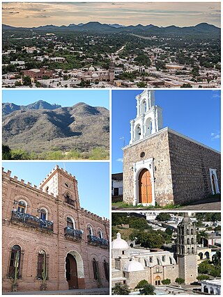
Álamos is a town in Álamos Municipality in the Mexican state of Sonora, in northwestern Mexico.

Santa Ana is a small city and municipal seat of Santa Ana Municipality in the Mexican state of Sonora. It is located 168 kilometres (104 mi) north of the state capital Hermosillo and 100 kilometres (62 mi) south of Nogales on the United States border. The town had a 2005 census population of 10,593 inhabitants.
Arivechi is a town in the Mexican state of Sonora. It serves as the municipal seat of the surrounding municipality of the same name.
Bacanora is a small town in Bacanora Municipality in the east of the Mexican state of Sonora. It is located at the geographical coordinates of 28°59′N109°24′W.

Bacoachi is a small town in Bacoachi Municipality in the north of the Mexican state of Sonora. The area of the municipality is 487 square miles (1,260.65 km2) and the population was 1,456 in 2005, with 924 inhabitants residing in the municipal seat. The elevation of the municipal seat is 4,429 feet above sea level.
Sahuaripa is a town in the Mexican state of Sonora, municipality of Sahuaripa. The area is 5,694.4 km². with a population of 5,792 in 2005. The town and municipal seat had a population of 3,807 in 2000.
Bácum is a small city and the county seat of Bácum Municipality, located in the south of the Mexican state of Sonora at 27°32′N110°05′W.
La Colorada is a small town in La Colorada Municipality in the Mexican state of Sonora in north-western Mexico. In 2005, the population of the municipality was 1,754, with 288 living in the municipal seat.

Caborca is the municipal seat of the Caborca Municipality in the Mexican state of Sonora. The city has a population of 67,604, while the municipal population was 89,122 as of 2020.
Huásabas is the municipal seat of Huásabas Municipality in the northeast of the Mexican state of Sonora. The municipal area is 711.17 km² (274.58 mi²) with a population of 966 registered in 2000. Most of the inhabitants live in the municipal seat.
Moctezuma is a municipio (municipality) of the Mexican state of Sonora, located in the state's central region. It is also the name of its largest settlement and cabecera municipal.

Ónavas is a small town surrounded by Onavas Municipality in the southeast of the Mexican state of Sonora.
Tepache is a small town in Tepache Municipality in the east of the Mexican state of Sonora. Its location by GPS coordinates is at: Longitude (dec): -109.528889; Latitude (dec): 29.533333.

Quiriego is a small town and the county seat of the Municipality of Quiriego, located in the southeast of the Mexican state of Sonora.
Rosario de Tesopaco is a small town, the seat of Rosario de Tesopaco Municipality in the southeast of the Mexican state of Sonora.
San Javier is a town in San Javier Municipality, in the Mexican state of Sonora. The elevation is 650 meters.
San Pedro de la Cueva is a town in San Pedro de la Cueva Municipality, in the Mexican state of Sonora. It is located in the center of the state at an elevation of 500 meters.
Suaqui Grande is a town in Suaqui Grande Municipality, in the eastern region of the Mexican state of Sonora. It was founded in 1620 by the Jesuit missionary Martín Burgencio as San Ignacio de Suaqui.
Tonichi is a town in the Soyopa Municipality, in the eastern region of the Mexican state of Sonora near the Río Yaqui. The elevation is 180 meters.

San Javier is a municipality in the state of Sonora in north-western Mexico. As of 2015, the municipality had a total population of 557.

