
Pima County is a county in the south central region of the U.S. state of Arizona. As of the 2020 census, the population was 1,043,433, making it Arizona's second-most populous county. The county seat is Tucson, where most of the population is centered. The county is named after the Pima Native Americans, also known as Tohono O'odham, who are indigenous to this area.
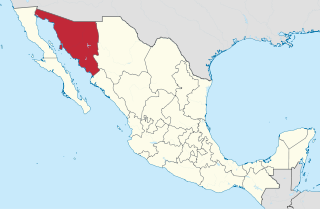
Sonora is a state in Northwestern Mexico that is divided into 72 municipalities. According to the 2020 Mexican census, it is the eighteenth most populated state with 2,944,840 inhabitants and the 2nd largest by land area spanning 179,354.7 square kilometres (69,249.2 sq mi). The largest municipality by population is Hermosillo, with 936,263 residents, while the smallest is Onavas with 365 residents. The largest municipality by land area is also Hermosillo which spans 15,724.30 km2 (6,071.19 sq mi), and the smallest is San Felipe de Jesús with 151.30 km2 (58.42 sq mi). The newest municipalities are Benito Juárez and San Ignacio Río Muerto, established in 1996.

Sonoyta, Sonora, is a town in the northern Mexican state of Sonora. It stands on the U.S.-Mexico border, facing Lukeville, Arizona, in the United States. It is the municipal seat of the municipality of Plutarco Elías Calles.
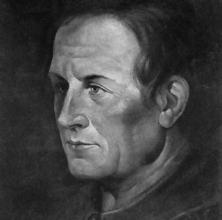
Eusebio Francisco Kino, SJ, often referred to as Father Kino, was an Italian Jesuit, missionary, geographer, explorer, cartographer, mathematician and astronomer born in the Bishopric of Trent, Holy Roman Empire.

The Spanish missions in the Sonoran Desert are a series of Jesuit Catholic religious outposts established by the Spanish Catholic Jesuits and other orders for religious conversions of the Pima and Tohono O'odham indigenous peoples residing in the Sonoran Desert. An added goal was giving Spain a colonial presence in their frontier territory of the Sonora y Sinaloa Province in the Viceroyalty of New Spain, and relocating by Indian Reductions settlements and encomiendas for agricultural, ranching, and mining labor.

Cananea is a municipality in the northern portion of the Mexican state of Sonora, on the U.S. border. Its municipal seat is the city of Cananea, located at 30°58′55″N110°18′02″W.

Magdalena de Kino is a city, part of the surrounding municipality of the same name, located in the Mexican state of Sonora covering approximately 560 square miles. According to the 2005 census, the city's population was 23,101, and the municipality's was 25,500. Magdalena de Kino is in the northern section of Sonora 50 miles from the Mexico-U.S. border. To the north the municipality abuts Nogales; to the south, the municipality of Santa Ana; to the east, Ímuris and Cucurpe; and to the west, the municipalities of Tubutama and Sáric. Its main sectors include San Ignacio, San Isidro, Tacicuri, and Sásabe. The city was named after the pioneer Roman Catholic missionary and explorer, Father Eusebio Francisco Kino, who worked in the area, as well as in the present-day US state of Arizona.
El Desemboque is a town located 376 km from Hermosillo on the shore of Gulf of California in the Mexican state of Sonora; coordinates N 29° 30' 13", W 112° 23' 43". It is part of the Municipality of Pitiquito, and is one of two major villages on the Seri Indian communal property, the other being Punta Chueca. The Spanish name refers to the fact that the Río San Ignacio meets the sea near that point. The Seri name is literally where the clams lie. It has been a good location to find the small clams Protothaca grata (haxöl). According to the Mexican census of 2010, the town had a population of 287 inhabitants. (The town of El Desemboque described in the prior text is not located in the Pitiquito municipality of Sonora. It is a Seri village about 120 km north of Punta Chueca north of Bahia Kino where the dry Rio Ignacio meets the Gulf of California. The El Desemboque in Pitiquito is west of Caborca at the mouth of Rio Concepcion and is a small village catering to weekenders from Caborca. The Seri may have lived at the El Desemboque west of present-day Caborca in prehistoric times before Spanish arrived as well as the current Seri town north of Bahia Kino. Their oral history has them living as far north as present day Puerto Penasco which was also an O'Odham settlement as well as present-day Bahia Kino and Isla Tiburon .)

Atil is a small town in Atil Municipality in the northwest of the Mexican state of Sonora. The total area is 400.43 km² and the population of the municipality was 734 in 2005, of whom 699 lived in the municipal seat (2000). Neighboring municipalities are Tubutama, Trincheras, Oquitoa, and Altar.
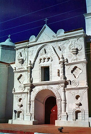
Mission San Pedro y San Pablo del Tubutama is a Spanish mission located in Tubutama, Sonora, first founded in 1691 by Eusebio Francisco Kino.

Caborca is the municipal seat of the Caborca Municipality in the Mexican state of Sonora. The city has a population of 67,604, while the municipal population was 89,122 as of 2020.

Plutarco Elías Calles is a municipality in the northwest of the Mexican state of Sonora. Its municipal seat and main urban center is Sonoyta, on the United States border opposite Lukeville, Arizona.
The Pima Revolt, also known as the O'odham Uprising or the Pima Outbreak, was a revolt of Pima native Americans in 1751 against colonial forces in Spanish Arizona and one of the major northern frontier conflicts in early New Spain.

Oquitoa is a municipality in the state of Sonora in north-western Mexico. The municipal seat is at Oquitoa.

Pitiquito is a municipality in the state of Sonora in north-western Mexico. The municipal seat is at Pitiquito.

Sáric is a municipality in the state of Sonora in north-western Mexico. Its northern boundary is the U.S. state of Arizona. The population of the municipality was 2,703 in 2010 living in an area of 1,676.23 square kilometers. The elevation is around 800 meters. At the city of Sáric, the municipal seat, it is 780 meters.
La Pintada is an archaeological site located some 60 kilometers south of the city of Hermosillo, Sonora, Mexico, within the "La Pintada" canyon, part of the "Sierra Libre", a small mountain massif of the coastal plains that extends throughout the Sonoran Desert.
Luís María Gallardi was a Jesuit missionary to New Spain.

The fifth federal electoral district of Sonora is one of the 300 electoral districts into which Mexico is divided for elections to the federal Chamber of Deputies and one of seven such districts in the state of Sonora.
Santa Fe, also known as Jesús Paz, is a semi-deserted ejido located in the municipality of Átil in the northern part of the Mexican state of Sonora, within the Sonoran Desert. It is the fourth most populated locality in the municipality with only 2 inhabitants, according to the 2020 Census by the INEGI.


