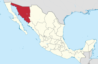
Sonora is a state in Northwestern Mexico that is divided into 72 municipalities. According to the 2020 Mexican census, it is the eighteenth most populated state with 2,944,840 inhabitants and the 2nd largest by land area spanning 179,354.7 square kilometres (69,249.2 sq mi). The largest municipality by population is Hermosillo, with 936,263 residents, while the smallest is Onavas with 365 residents. The largest municipality by land area is also Hermosillo which spans 15,724.30 km2 (6,071.19 sq mi), and the smallest is San Felipe de Jesús with 151.30 km2 (58.42 sq mi). The newest municipalities are Benito Juárez and San Ignacio Río Muerto, established in 1996.

Municipalities are the second-level administrative divisions of Mexico, where the first-level administrative division is the state. They should not be confused with cities or towns that may share the same name as they are distinct entities and do not share geographical boundaries. As of March 2024, there are 2,476 municipalities in Mexico, excluding the 16 boroughs of Mexico City.

El Porvenir is a municipality and township in the Mexican state of Chiapas.
Benjamín Hill is the municipal seat of Benjamín Hill Municipality in the Mexican state of Sonora.

Carbó is the municipal seat of Carbó Municipality of the state of Sonora, Mexico.
Opodepe is the municipal seat of Opodepe Municipality in the north of the Mexican state of Sonora.
Rayón is a small town surrounded by its municipal area in the center of the Mexican state of Sonora at a distance of 110 kilometers from the state capital Hermosillo.
Nezahualcóyotl, or more commonly Neza, is a city and municipal seat of the municipality of Nezahualcóyotl in Mexico. It is located in the state of Mexico, adjacent to the east side of Mexico City. The municipality comprises its own intrastate region, Region IX.
El Higo is a municipality of the Mexican state of Veracruz. It is located in the state's Huasteca Alta region. The municipal seat is the village of El Higo, Veracruz.

Pánuco is a municipality in the Mexican state of Veracruz. It is located in the Huasteca Alta region of Veracruz and shares borders with the states of San Luis Potosí and Tamaulipas. The municipal seat is the city of Pánuco, Veracruz.

Pilcaya is a municipality in the Mexican state of Guerrero. The municipal seat lies at Pilcaya. The municipality covers an area of 62.1 km².
Xochistlahuaca Municipality is a municipality in the Mexican state of Guerrero. The municipal seat lies at Xochistlahuaca. The municipality covers an area of 321.1 km².
Tecámac is a municipality in State of Mexico in Mexico. The municipality covers an area of 157.34 km². The municipal seat lies in the town (locality) of Tecámac de Felipe Villanueva. Its largest town, Ojo de Agua, with a population of 242,283 inhabitants, is the largest locality in Mexico that is not a municipal seat.

Huaquechula Municipality is a municipality in Puebla in south-eastern Mexico.

Puebla Municipality is a municipality in the State of Puebla in eastern Central Mexico. The municipality covers a total area of 534.32 square kilometres (206.30 sq mi). The City of Puebla is the municipal seat, as well as the capital of the state.

Zacatlán Municipality is a municipality in the Mexican state of Puebla in south-eastern Mexico. Its administrative centre is the city of Zacatlán.
Álamos Municipality is a municipality in south-western Sonora, Mexico. It includes the town of Álamos.

Arizpe (municipality) is a municipality in the Mexican state of Sonora in north-western Mexico. The Municipality of Arizpe is one of the 72 municipalities of the state of Sonora, located in the north-central region of the state in the Sierra Madre Occidental area. It has 72 localities within the municipality, its municipal seat and the most populated locality is the homonymous town of Arizpe, while other important ones are: Sinoquipe, Bacanuchi and Chinapa. It was named for the first time as a municipality in 1813 and according to the 14th Population and Housing Census carried out in 2020 by the National Institute of Statistics and Geography (INEGI) the municipality has a total population of 2,788 inhabitants. This municipality has an area of 1,186.56 square miles (3,073.17 km2). Its Gross Domestic Product per capita is USD 11,012, and its Human Development Index (HDI) is 0.8292.
Carbó (municipality) is a municipality in the Mexican state of Sonora in north-western Mexico.

Cucurpe Municipality is a municipality in the Mexican state of Sonora in north-western Mexico.


