This article relies largely or entirely on a single source .(January 2021) |
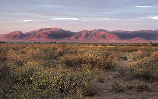
San Bernardino Lagunas (also, Lagunas) is a village in Agua Prieta Municipality in the Mexican state of Sonora, Mexico.
This article relies largely or entirely on a single source .(January 2021) |
San Bernardino Lagunas (also, Lagunas) is a village in Agua Prieta Municipality in the Mexican state of Sonora, Mexico.

Southern California is a geographic and cultural region that generally comprises the southern portion of the U.S. state of California. It includes the Los Angeles metropolitan area, the second most populous urban agglomeration in the United States. The region generally contains ten of California's 58 counties: Imperial, Kern, Los Angeles, Orange, Riverside, San Bernardino, San Diego, Santa Barbara, San Luis Obispo and Ventura counties.

Beclabito is a census-designated place (CDP) in San Juan County, New Mexico, United States. The population was 317 at the 2010 census. It is part of the Farmington Metropolitan Statistical Area.
Agua Prieta is a town in Agua Prieta Municipality in the northeastern corner of the Mexican state of Sonora. It stands on the Mexico–U.S. border, adjacent to the town of Douglas, Arizona. The municipality covers an area of 3,631.65 km2. In the 2010 census the town had a population of 79,138 people, making it the seventh-largest community in the state, and a literacy rate of 96.3%.

The Mexican Riviera refers collectively to twenty cities and lagoons lying on the western coast of Mexico. Although there are long distances between these cities, they are often collectively referred to as the Mexican Riviera because of their many oceanfront resorts and their popularity among tourists. Cruise ships often visit three or four of these destinations on their longer cruises. In a 2005 interview Stanley McDonald, the founder of Princess Cruises, mentioned:
The call of the "Mexican Riviera" was coined by Princess Cruise Line. Now everyone refers to it as the Mexican Riviera. I believe that it really spoke to the quality and beauty of what people would see down there. We all know the French Riviera -- the Mexican Riviera was something we had in the western hemisphere.
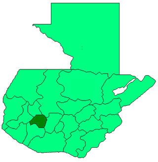
San Pablo La Laguna is a municipality in the Sololá department of Guatemala. It consists of the village that bears the name San Pablo La Laguna which is situated on the shore of Lake Atitlan between the villages of San Juan La Laguna and San Marcos La Laguna.

Federal Highway 1 is a free (libre) part of the federal highway corridors of Mexico, and the highway follows the length of the Baja California Peninsula from Tijuana, Baja California, in the north to Cabo San Lucas, Baja California Sur, in the south. The road connects with Via Rapida, which merges into the American Interstate 5 (I-5) at the San Ysidro Port of Entry, which crosses the international border south of San Ysidro, California.
Malpai Borderlands is a region, or areal feature, along the U.S.-Mexico border at the Arizona and New Mexico state line. It encompasses the extreme southeast corner of Arizona and the southwest corner of New Mexico describe the general vicinity. It includes areas inside the U.S. states of Arizona and New Mexico as well as the Mexican states of Chihuahua and Sonora.
California's 40th congressional district is a congressional district in the U.S. state of California, encompassing Orange, San Bernardino, and Riverside counties. The district is currently represented by Republican Young Kim. It was one of 18 districts that voted for Joe Biden in the 2020 presidential election while being won or held by a Republican in 2022.
Villa Hidalgo Municipality is a municipality, in the north-east of the Mexican state of Sonora.
San Juan Bautista Coixtlahuaca is a small town and municipality located in the Mixteca Region of the State of Oaxaca, Mexico, and the center of the Coixtlahuaca district. The name, "Coixtlahuaca" means 'plain of snakes' in the Nahuatl language.
San Bernardino is a village in Sonora, Mexico.
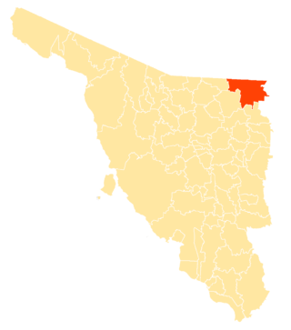
Agua Prieta Municipality is a municipality in the Mexican state of Sonora in north-western Mexico. As of 2015, the municipality had a total population of 82,918.
The San Simon Valley is a broad valley east of the Chiricahua Mountains, in the northeast corner of Cochise County, Arizona and southeastern Graham County, with a small portion near Antelope Pass in Hidalgo County of southwestern New Mexico. The valley trends generally north–south but in its northern portion trends northwest–southeast. The San Simon Valley separates the Chiricahua Mountains, Dos Cabezas Mountains and Pinaleno Mountains on the west from the Peloncillo Mountains and the smaller Whitlock Mountains to the east.

The San Bernardino Valley of Arizona is a 35 mi (56 km) northeast-by-southwest trending valley in extreme southeast Cochise County, Arizona. The north end of the valley merges into the northwest-by-southeast trending San Simon Valley; both merge in western perimeter Hidaldgo County, New Mexico. The valley is an asymmetric graben.
The 1892 Laguna Salada earthquake occurred at 23:20 Pacific Standard Time on February 23. It had an estimated moment magnitude of 7.1–7.2 and a maximum perceived intensity of VIII (Severe). The shock was centered near the Mexico–United States border and takes its name from a large dry lake bed in Baja California, Mexico. There were no reported casualties, but the event affected the then largely-uninhabited areas of northern Mexico and Southern California.

Laguña Creek also formerly also known as Tyende Creek, is a stream in the Navajo and Apache Counties of Arizona. Laguña Creek has its source at 36°41′15″N110°30′36″W, at the confluence of Long Canyon and Dowozhiebito Canyon at an elevation of 6,325 feet at the head of Tsegi Canyon. Its mouth is in the Chinle Valley at its confluence with Chinle Wash which together forms Chinle Creek, at an elevation of 4,774 feet. Chinle Creek is a tributary of San Juan River which is in turn a tributary of the Colorado River.

Chinle Creek is a tributary stream of the San Juan River in Apache County, Arizona and San Juan County, Utah. Its source is at 36°53′40″N109°44′37″W, the confluence of Laguña Creek and the Chinle Wash arroyo. Its name is derived from the Navajo word ch'inili meaning 'where the waters came out. Its sources is in Canyon de Chelly National Monument where Canyon de Chelly and Canyon del Muerto have their confluence at an elevation of 5,616 feet at 36°08′35″N109°29′17″W. It then trends northwest to its confluence with Laguña Creek where it forms Chinle Creek, 7 miles northeast of Dennehotso, Arizona at an elevation of 4,774 feet.
Whitewater Draw, originally Rio de Agua Prieta, [Spanish: river of dark water], is a tributary stream of the Rio de Agua Prieta in Cochise County, Arizona. It was called Blackwater Creek by Philip St. George Cooke when his command, the Mormon Battalion, camped at a spring on its course on December 5, 1846.
Black Draw is a valley, and tributary stream within the San Bernardino Valley of Cochise County, Arizona. Its waters are a tributary of the San Bernardino River and its mouth lies at an elevation of 3,753 feet / 1,144 meters. Its source is at an elevation of 4,740 feet, at 31°34′17″N109°10′12″W on the northwest slope of Paramore Crater in the upper San Bernardino Valley.
Cooke's Wagon Road or Cooke's Road was the first wagon road between the Rio Grande and the Colorado River to San Diego, through the Mexican provinces of Nuevo México, Chihuahua, Sonora and Alta California, established by Philip St. George Cooke and the Mormon Battalion, from October 19, 1846 to January 29, 1847 during the Mexican–American War. It became the first of the wagon routes between New Mexico and California that with subsequent modifications before and during the California Gold Rush eventually became known as the Southern Trail or Southern Emigrant Trail.
| | This article about a location in the Mexican state of Puebla is a stub. You can help Wikipedia by expanding it. |