Related Research Articles
Tayasal is a Maya archaeological site located in present-day Guatemala. It was a large Maya city with a long history of occupation. Tayasal is a corruption of Tah Itza, a term originally used to refer to the core of the Itza territory in Petén. The name Tayasal was applied in error to the archaeological site, and originally applied to the Itza capital. However, the name now refers to the peninsula supporting both the archaeological site and the village of San Miguel. The site was occupied from the Middle Preclassic period through to the Late Postclassic (c. 1200–1539 AD).
Mixco Viejo, occasionally spelt Mixcu Viejo, is an archaeological site in the north east of the Chimaltenango department of Guatemala, some 50 kilometres (31 mi) to the north of Guatemala City and 4 kilometres (2.5 mi) from the junction of the rivers Pixcaya and Motagua. It is a moderate sized ruined city of the Postclassic Maya civilization.

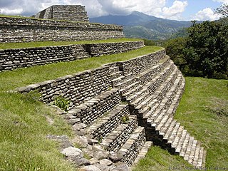
Cantona is a Mesoamerican archaeological site in Mexico. It is located between 2,450 and 2,600 meters above sea level in the state of Puebla, on the border with the state of Veracruz. The site lies about an hour's drive from the city of Puebla and about an hour and a half from Xalapa, Veracruz. Limited archaeological work has been done at the site. It is estimated that only one to ten per cent of the site can be seen.
The Chachapoyas, also called the "Warriors of the Clouds", was a culture of the Andes living in the cloud forests of the southern part of the Department of Amazonas of present-day Peru. The Inca Empire conquered their civilization shortly before the Spanish conquest in the 16th century. At the time of the arrival of the conquistadors, the Chachapoyas were one of the many nations ruled by the Incas, although their incorporation had been difficult due to their constant resistance to Inca troops.

La Quemada is an archeological site. It is located in the Villanueva Municipality, in the state of Zacatecas, about 56 km south of the city of Zacatecas on Fed 54 Zacatecas–Guadalajara, in Mexico.

Kuélap or Cuélap is a walled settlement located in the mountains near the towns of María and Tingo, in the southern part of the region of Amazonas, Peru. It was built by the Chachapoyas culture in the 6th century AD on a ridge overlooking the Utcubamba Valley.
El Baúl is a Pre-Columbian archaeological site in present-day Escuintla Department, Guatemala. El Baúl, along with the sites of Bilbao and El Castillo, is part of the Cotzumalhuapa Archaeological Zone. It was occupied during the prehistoric Formative stage of the Americas.

El Puente, or the Parque Arqueológico El Puente, is a Maya archaeological site in the department of Copán in Honduras. Once an independent Maya city, the city of El Puente became a tributary to the nearby city of Copán between the 6th and 9th centuries AD. The site contains more than 200 structures that include tombs, religious structures, and living quarters, but only a few have been excavated, including a large Maya step pyramid.
Guiengola is a Zapotec archeological site located 14 km (8.7 mi) north of Tehuantepec, and 243 km (151 mi) southeast of Oaxaca city on Federal Highway 190. The visible ruins are located between a hill and a river, each carries the name of Guiengola. The name means "large stone" in the local variant of the Zapotec language. There are two main tombs that have been excavated, and both seem to be family interment sites. Both have front chambers that are for religious idols, while the rear chambers are for the burial of important people. The site also has fortified walls, houses, ballgame fields, other tombs and a very large "palace" with remains of artificial ponds and terraces. In the center of the site are 2 plazas, one lower than the other, and 2 pyramids, one to the east and one to the west.
El Cóporo is a prehispanic archaeological site at the northern frontiers of the Mesoamerican cultural area, located at an elevation of 150 meters on the western slopes of the Santa Bárbara range, near the San José del Torreón community, and lies some 15 kilometres (9 mi) due south of its municipal seat and largest township, on the northwestern corner of Guanajuato state, Mexico.

Cara Sucia is a Mesoamerican archaeological site on the Pacific coastal plain of western El Salvador. It was occupied for some 1,800 years, and is particularly noted as one of the southeasternmost sites of the Late Classic Cotzumalhuapa culture which extended over much of the Pacific drainage of Guatemala and included part of the Salvadoran departments of Ahuachapán and Sonsonate.

Altavista, or Chalchihuites, is an archaeological site near the municipality of Chalchihuites in the Mexican state of Zacatecas, in the northwest of Mexico. It is believed that the site was a cultural oasis that was occupied more or less continuously from AD 100 to AD 1400.
El Conde is an archeological site located at Ozumba Street, El Conde, three block north the Mayo 1 Ave., in the municipality of Naucalpan, Mexico State.

La Ferrería is an archaeological site located 7 kilometers south of the city of Durango, in the Mexican state of Durango, at the “Cerro de La Ferrería”, on the side of the Tunal River.

Ichma, Ychma, Yschma, Ychsma, Ichmay, Irma, Izma, Ishmay or Ishma was a pre-Inca indigenous polity later absorbed by the Inca Empire and reorganized as a wanami (province). For the Inca it was known as Pachakamaq (Pachacamac), rather than its original name of Ishma.

Piruro is an archaeological site in Peru. It is situated in the Huánuco Region, Huamalíes Province, Tantamayo District. The site was declared a National Cultural Heritage by Resolución Directoral No. 533/INC on June 18, 2002.

Termantia, the present-day locality of Tiermes, is an archaeological site on the edge of the Duero valley in Spain. It is located in the sparsely populated municipio of Montejo de Tiermes.

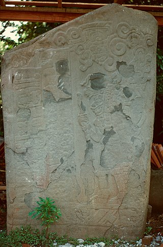
Chutixtiox is an archaeological site of the ancient Maya civilization near Sacapulas, in the Quiché department of modern Guatemala. The site was excavated during the 20th century by A. Ledyard Smith. Ceramic evidence excavated at the site suggests a close relationship with the K'iche' capital of Q'umarkaj. Chutixtiox may have been a settlement in a polity that included the nearby sites of Chutinamit and Xolpacol.

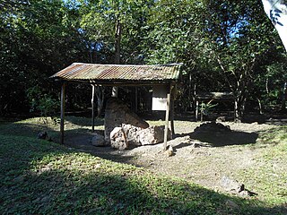
Cerro Quiac is a small Maya archaeological site located at an altitude of 2,635 metres (8,645 ft), overlooking the Plains of Urbina in the Guatemalan Highlands. When investigated in 1970 it had five stone sculptures, by 1977 only four were left. The sculptures included figures and geometric decoration. The site is still used for contemporary Maya rituals. Cerro Quiac is located in the northeast of the municipality of Cantel, within the boundaries of the hamlet of Chirijquiac.
Huaycán de Pariachi is an archaeological site in Peru. It is located in Huaycán, Ate District, Lima. It is located south of the Rímac River.
References
- ↑ "La zona arqueológica de Tepexi". 2010-08-05. Retrieved 2016-11-09.
- ↑ "Zona Arqueológica Tepexi el Viejo". inah.gob.mx. Retrieved 2016-04-09.
| | This Mexico location article is a stub. You can help Wikipedia by expanding it. |