Leka is a municipality in Trøndelag county, Norway. It is part of the Namdalen region. The administrative centre of the municipality is the village of Leknes on the island of Leka. Other villages in Leka include Sør-Gutvika and Madsøygrenda. The island municipality includes all of the island of Leka and part of the island of Austra as well as hundreds of smaller surrounding islands and skerries.
Sømna is a municipality in Nordland county, Norway. It is part of the Helgeland traditional region. The administrative center of Sømna is the village of Vik i Helgeland. Other villages in the municipality include Dalbotn, Sund, Vennesund, and Berg.

Brønnøy is a municipality in Nordland county, Norway. It is part of the Helgeland region. The administrative centre and commercial centre of the municipality is the town of Brønnøysund. A secondary centre is the village of Hommelstø. Other villages include Tosbotn, Lande, Trælnes, and Indreskomo.
Vega is a municipality in Nordland county, Norway. It is part of the Helgeland traditional region. The administrative centre of the municipality is the village of Gladstad. Other villages include Holand and Ylvingen.
Træna is a municipality in Nordland county, Norway. It is part of the Helgeland traditional region. The administrative centre of the municipality is the island/village of Husøya. Other population centres include Selvær and Sanna.

Flakstad is a municipality in Nordland county, Norway. It is part of the traditional district of Lofoten. The administrative centre of the municipality is the village of Ramberg. Other villages include Fredvang, Napp, Nusfjord, and Vareid.
Bø is a municipality in Nordland county, Norway. It is part of the Vesterålen region. The administrative centre of the municipality is the village of Straume. Other villages in the municipality include Auvåg, the village of Bø, Eidet, Guvåg, Hovden, Klakksjorda, Malnes, Nykvåg, Utskor, and Vågen. The Litløy Lighthouse is located on the tiny island of Litløya off the coast of Bø.

Risøyhamn is a village in Andøy Municipality in Nordland county, Norway. The village is located on the southern part of the island of Andøya. The island of Andøya is connected to the neighboring island of Hinnøya by the Andøy Bridge at Risøyhamn. The Hurtigruten coastal express boat has service to and from Risøyhamn twice a day.
The Vassås Bridge is a cantilever bridge that crosses the Osan fjord in the municipality of Bindal in Nordland county, Norway. The bridge is part of Norwegian County Road 1 and it connects the villages of Vassås and Terråk. The Vassås Bridge was opened in 1980 and is 400 metres (1,300 ft) long with a main span of 160 metres (520 ft).
Bjerka is a village in the municipality of Hemnes in Nordland county, Norway. It is located along the European route E06 highway and the Nordland Line, about 20 kilometres (12 mi) southeast of Hemnesberget and about 7 kilometres (4.3 mi) north of the municipal center of Korgen.
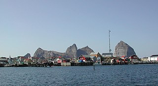
Reine is the administrative centre of Moskenes Municipality in Nordland county, Norway. The fishing village is located on the island of Moskenesøya in the Lofoten archipelago, above the Arctic Circle, about 300 kilometres (190 mi) southwest of the town of Tromsø. Reine Church is located here and it serves the northern part of the municipality.

Straumsnes or Strømsnes is a village in the municipality of Fauske in Nordland county, Norway. It is located in the Valnesfjord area of Fauske. The town of Fauske lies 15 kilometres (9.3 mi) to the east and the town of Bodø lies about 40 kilometres (25 mi) to the west. The village sits just inland of Skjerstad Fjord, along the southern shore of the lake Valnesfjordvatnet.
Alsvåg is a village in the municipality of Øksnes in Nordland county, Norway. It is located on the western bank of the Gavlfjorden on the island of Langøya and about 8 kilometres (5.0 mi) east of the municipal centre of Myre. Alsvåg Church is located in this village.

Velfjord is a former municipality in Nordland county, Norway. The 600-square-kilometre (230 sq mi) municipality existed from 1875 until its dissolution in 1964. Velfjord municipality was centered around the Velfjorden in what is now Brønnøy Municipality. Most of the municipality is located on the mainland, but it also includes nearly 100 small islands, islet, and skjerries. The administrative centre was the village of Hommelstø at the innermost part of the fjord. Velfjord Church lies just west of Hommelstø.
Åbjøra or Åelva is a river in the municipality of Bindal in Nordland county, Norway. It begins in the mountains between the Tosen fjord and the Namdalen valley. The 59-kilometre (37 mi) long river passes through some lakes, including the lake Åbjørvatnet, then past the village of Åbygda, and ends in the Osan fjord, not far from the village of Terråk. It is a small river but good for fishing for salmon or sea trout.
Åbygda is a village in the municipality of Bindal in Nordland county, Norway. The village is located along the river Åbjøra, about 10 kilometres (6.2 mi) southeast of the villages of Vassås and Terråk.
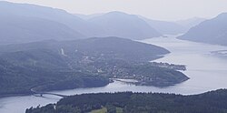
Vassås is a small village in the municipality of Bindal in Nordland county, Norway. It is located along the Tosen arm of the Bindalsfjorden, just north of the Vassås Bridge which connects the village to the larger village of Terråk. The village of Åbygda lies about 10 kilometres (6.2 mi) to the southeast. This is also the site of Vassås Church, the parish church for this part of Bindal.

Vassås Church is a parish church of the Church of Norway in Bindal Municipality in Nordland county, Norway. It is located in the village of Vassås. It is one of the two churches for the Bindal parish which is part of the Sør-Helgeland prosti (deanery) in the Diocese of Sør-Hålogaland. The white, wooden church was built in a octagonal style in 1734 by the architect Nils Ryjord. The church seats about 250 people.

Sortland (help·info) is a town and the administrative centre of Sortland Municipality in Nordland county, Norway. The town is located on the east coast of the island of Langøya, along the Sortlandsundet strait. In 1997, the municipality decided to declare "town status" for the urban area of Sortland. Sortland is the largest town and commercial centre in the whole Vesterålen region and it is becoming known as "the blue town by the strait" since many of the buildings are painted blue.