
Tippah County is a county located on the northern border of the U.S. state of Mississippi. As of the 2020 census, the population was 21,815. Its county seat is Ripley. The name "Tippah" is derived from a Chickasaw language word meaning "cut off." It was taken from the creek of the same name that flows across much of the original county from northeast to southwest before emptying into the Tallahatchie River. The creek probably was so named because it, and the ridges on either side, "cut off" the western part of the region from the eastern portion.

Tallahatchie County is a county in the U.S. state of Mississippi. At the 2020 census, the population was 12,715. Its county seats are Charleston and Sumner.

Prentiss County is a county located in the U.S. state of Mississippi. As of the 2020 census, the population was 25,008. Its county seat is Booneville. The county is named for Seargent Smith Prentiss, a noted speaker and US Congressman from Natchez.

Calhoun County is a county located in the U.S. state of Mississippi. As of the 2020 census, the population was 13,266. Its county seat is Pittsboro. The county is named after John C. Calhoun, the U.S. Vice President and U.S. Senator from South Carolina.

Wabasha County is a county in the U.S. state of Minnesota. As of the 2020 census, the population was 21,387. Its county seat is Wabasha.

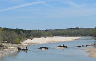
The Yalobusha River is a river, 165 miles (266 km) long, in north-central Mississippi in the United States. It is a principal tributary of the Yazoo River, via which it is part of the watershed of the Mississippi River.
The Homochitto River is a river in the U.S. State of Mississippi. It flows from its source in southwest Mississippi for about 90 miles (145 km) west and south, emptying into the Mississippi River between Natchez and Woodville.

Temescal Creek is an approximately 29-mile-long (47 km) watercourse in Riverside County, in the U.S. state of California. Flowing primarily in a northwestern direction, it connects Lake Elsinore with the Santa Ana River. It drains the eastern slopes of the Santa Ana Mountains on its left and on its right the western slopes of the Temescal Mountains along its length. With a drainage basin of about 1,000 square miles (2,600 km2), it is the largest tributary of the Santa Ana River, hydrologically connecting the 720-square-mile (1,900 km2) San Jacinto River and Lake Elsinore watersheds to the rest of the Santa Ana watershed. However, flowing through an arid rain shadow zone of the Santa Ana Mountains, and with diversion of ground water for human use, the creek today is ephemeral for most of its length, except for runoff from housing developments and agricultural return flows.
San Felipe Creek is a stream in Imperial and San Diego Counties of California. It arises in the Volcan Mountains of San Diego County 33°11′57″N116°37′35″W, and runs eastward, gathering the waters of most of the eastern slope of the mountains and desert of the county in the San Sebastian Marsh before it empties into the Salton Sea. It is probably the last remaining perennial natural desert stream in the Colorado Desert region. In 1974, the San Felipe Creek Area was designated as a National Natural Landmark by the National Park Service.
Bull Canyon is a canyon at the top of Palm Canyon Wash, which is a tributary to the Whitewater River, in Riverside County, California. Bull Canyon and the creek of Palm Canyon Wash heads at 33°36′47″N116°33′23″W, at an elevation of 6,165 feet in the southern western slope of a ridge in the San Jacinto Mountains. The waters of the creek of Palm Canyon Wash are augmented by Bull Canyon Spring at 33°35′22″N116°33′24″W, at an elevation of 5,331 feet / 1,625 meters. The mouth of Bull Canyon is at an elevation of 4,508 feet / 1,374 meters at the head of Palm Canyon. The mouth of an unnamed creek flows north down from Vandeventer Flat into the head of Palm Canyon at its confluence with Palm Canyon Wash at 33°34′08″N116°31′43″W at an elevation of 4,460 feet.
Bogue Phalia is a stream in the U.S. state of Mississippi. It is a tributary to the Big Sunflower River.
Bophumpa Creek is a stream in Holmes County in the U.S. state of Mississippi. It is a tributary to Fannegusha Creek.
Chicopa Creek is a stream in the U.S. state of Mississippi.
Coila Creek is a stream in the U.S. state of Mississippi.
Houlka Creek is a stream in the U.S. state of Mississippi. It is a tributary to Chuquatonchee Creek.
Old Fannegusha Creek is a stream in Holmes County the U.S. state of Mississippi. It is a tributary to Tchula Lake.
Fannegusha Creek is a stream in Carroll and Holmes counties in east-central Mississippi. It is a tributary to the Blissdale Swamp.
Potacocowa Creek is a stream in the U.S. state of Mississippi.
Teoc Creek is a stream in the U.S. state of Mississippi.
Tillatoba Creek is a stream in the U.S. state of Mississippi. It is a tributary to the Tallahatchie River.


