Related Research Articles

Monroe Charter Township is a charter township of Monroe County in the U.S. state of Michigan. As of the 2020 census, the township population was 14,391.
The Teslin Tlingit Council (TTC) is a First Nation band government in the central Yukon in Canada, located in Teslin, Yukon along the Alaska Highway and Teslin Lake. The language originally spoken by the Teslin Tlingit or Deisleen Ḵwáan is Tlingit. Together with the Taku River Tlingit or Áa Tlein Ḵwáan around Atlin Lake of the Taku River Tlingit First Nation in British Columbia, and carcross tagish first nation or natasaaheeni, they comprise the Inland Tlingit.

Ross River is an unincorporated community in Yukon, Canada. It lies at the junction of the Ross River and the Pelly River, along the Canol Road, not far from the Campbell Highway. Primary access to the Campbell Highway is via a nine-mile access road. Formerly it was accessed along a six-mile Canol Road section that is no longer maintained. It is serviced by Ross River Airport, used mainly for charter and scheduled flights to and from Whitehorse and Watson Lake.
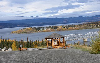
The community of Teslin(/'tɛs.lɪn/ TESS-lin) includes the Village of Teslin in Yukon, Canada. Teslin is situated at historical Mile 804 on the Alaska Highway along Teslin Lake. The Hudson's Bay Company established a small trading post at Teslin in 1903.

The Teslin River is a river in southern Yukon Territory and northwestern British Columbia, Canada, that flows 632 kilometres (393 mi) from its source south of Teslin Lake to its confluence with the Yukon River.
CIAY-FM, branded as Life 100.7, is a Christian radio station in Whitehorse, Yukon, Canada. CIAY-FM broadcasts at 100.7 FM airing a combination of religious programming and Contemporary Christian music.

Swift River is a settlement in the Canadian territory of Yukon, primarily a service stop on the Alaska Highway at historical mile 733. The radius of the area is estimated to be about 22.71 square kilometres ). The only permanent population owns and operates, or is employed at, the area's commercial highway establishment. Other residents are transient, working at the Yukon government's highway maintenance camp.
Warda is an unincorporated community in northern Fayette County, Texas, United States, the area became settled in 1854 by the Wends of Texas. Although it is unincorporated, Warda maintains a post office, with the ZIP code 78960.
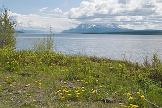
Teslin Lake is a large lake spanning the border between British Columbia and Yukon, Canada. It is one of a group of large lakes in the region of far northwestern BC, east of the upper Alaska Panhandle, which are the southern extremity of the basin of the Yukon River, and which are known in Yukon as "the Southern Lakes". The lake is fed and drained primarily by the Teslin River, south and north, but is also fed from the east by the Jennings River and the Swift River, and from the west by the Hayes River.
Otter Lake is the nane of a number of lakes, rives and a community in Nova Scotia).
The Swift River is a river that begins in Yukon Territory and flows southwest into British Columbia to its mouth at the east side of Teslin Lake on the Teslin River system. The river drains the uppermost portion of the Cassiar Mountains and in its lower reaches traverses the Nisutlin Plateau, which lies along the east side of Teslin Lake north of the mouth of the Jennings River, which is to the south of the Swift.
The Jennings River is a river in far northern British Columbia, Canada. It is approximately 150 kilometres (93 mi) long. The river was named for William T. Jennings (1846-1906), a civil engineer who, in 1897, assessed various road and railroad routes from the Pacific Ocean to the Yukon.
The Hayes River is a river in far northern British Columbia, Canada, flowing into Teslin Lake from the west, just to the west of the entry into that lake of the Teslin River. Other rivers feeding Teslin Lake include the Jennings River and the Swift River.
Yorkville is an unincorporated community in Mendocino County, California. It is located 7.5 miles (12 km) southwest of Hopland, at an elevation of 922 feet (281 m).
The Taku River Tlingit First Nation are the band government of the Inland Tlingit in far northern British Columbia, Canada and also in Yukon. They comprise two ḵwaan (tribes) of the Tlingit people, who are otherwise coastal, the Áa Tlein Ḵwáan of the Atlin Lake area and the Deisleen Ḵwáan of Teslin Lake, whose main focus is the Teslin Tlingit Council in Teslin, Yukon. Their band offices are in Atlin, British Columbia.
Waterton is an unincorporated community in Huntington Township, Luzerne County, Pennsylvania, United States. It lies between the boroughs of New Columbus and Shickshinny.
Teslin is the anglicized form of the name of the Deisleen Ḵwáan of the Tlingit people, one of two ḵwáan that are today incorporated as the Teslin Tlingit Council government in the Yukon Territory of northern Canada. As a term it may also refer to:
Teslin Crossing is an unincorporated area in Yukon, Canada, located on the Teslin River about 40 km (25 mi) north-northeast of Whitehorse.
Teslin River is an unincorporated area in the Yukon Territory, Canada, located on the west bank of the Teslin River at a crossing of that river on the Alaska Highway, about 40 km (25 mi) northwest of the Village of Teslin, which is on the east shore of Teslin Lake as is the neighbouring community of Teslin Lake. The settlement of Johnsons Crossing is on the east bank at that point, while the lake and community of Little Teslin Lake is located farther along the highway about 10 km (6 mi) west.
Terry Township is an unincorporated geographic township in the Unorganized West part of Timiskaming District in Northeastern Ontario, Canada. The township lies on the northern edge of Timaskaming District on the border with Cochrane District.
References
60°13′59″N132°54′50″W / 60.23306°N 132.91389°W
| | This article about a Yukon location is a stub. You can help Wikipedia by expanding it. |