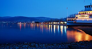
Penticton is a city in the Okanagan Valley of the Southern Interior of British Columbia, Canada, situated between Okanagan and Skaha lakes. In the 2016 Canadian Census, its population was 33,761, while its census agglomeration population was 43,432.

The Okanagan, also called the Okanagan Valley and sometimes the Okanagan Country, is a region in the Canadian province of British Columbia defined by the basin of Okanagan Lake and the Canadian portion of the Okanagan River. It is part of the Okanagan Country, extending into the United States as Okanogan County in north-central Washington. According to the 2016 Canadian census, the region's population is 362,258. The largest populated cities are Kelowna, Penticton, Vernon, and West Kelowna.

The Okanogan River is a tributary of the Columbia River, approximately 115 mi (185 km) long, in southern British Columbia and north central Washington. It drains a scenic plateau region called the Okanagan Country east of the Cascade Range and north and west of the Columbia, and also the Okanagan region of British Columbia. The Canadian portion of the river has been channelized since the mid-1950s.

Oliver is a town near the south end of the Okanagan Valley in the Southern Interior of British Columbia, Canada, with a population of nearly 5,000 people. It is located along the Okanagan River by Tuc-el-nuit Lake between Osoyoos and Okanagan Falls, and is labelled as the Wine Capital of Canada by Tourism British Columbia. It was once "The Home of the Cantaloupe" as well as the "Home of the International Horseshow."

Kootenay Lake is a lake located in British Columbia, Canada. It is part of the Kootenay River. The lake has been raised by the Corra Linn Dam and has a dike system at the southern end, which, along with industry in the 1950s–70s, has changed the ecosystem in and around the water. The Kootenay Lake ferry is a year-round toll-free ferry that crosses between Kootenay Bay and Balfour. The lake is a popular summer tourist destination.

The Similkameen River runs through southern British Columbia, Canada, eventually discharging into the Okanagan River near Oroville, Washington, in the United States. Through the Okanagan River, it drains to the Columbia River. The river is said to be named for an indigenous people called Similkameigh, meaning "treacherous waters".

Mount Boucherie is a mountain located in West Kelowna on the west shore of Okanagan Lake, British Columbia, Canada, opposite the city of Kelowna. It is the remnants of a former stratovolcano created nearly 60 million years ago. Between four and six different glacial periods over the past 50 million years have eroded the volcano to produce Mount Boucherie. Though it now only rises 417 metres above the nearby lake level, it is estimated to once have had an elevation of 2,000 m (6,562 ft) or more.

The Mount Meager massif is a group of volcanic peaks in the Pacific Ranges of the Coast Mountains in southwestern British Columbia, Canada. Part of the Cascade Volcanic Arc of western North America, it is located 150 km (93 mi) north of Vancouver at the northern end of the Pemberton Valley and reaches a maximum elevation of 2,680 m (8,790 ft). The massif is capped by several eroded volcanic edifices, including lava domes, volcanic plugs and overlapping piles of lava flows; these form at least six major summits including Mount Meager which is the second highest of the massif.
The Okanagan Indian Band is a First Nations government in the Canadian province of British Columbia, located in the city of Vernon in the northern Okanagan Valley. The band is a member government of the Okanagan Nation Alliance.

Vaseux Lake is a shallow freshwater lake located along the course of the Okanagan River in the Okanagan Valley of British Columbia, Canada.

West Kelowna, formerly known as Westside and colloquially known as Westbank, is a city in British Columbia's Okanagan Valley on the west shore of Okanagan Lake. The city encompasses several neighbourhoods, including Casa Loma, Gellatly, Glenrosa, Lakeview Heights, Shannon Lake, Smith Creek, Rose Valley, Westbank, and West Kelowna Estates. As of 2021, West Kelowna had an estimated population of 36,078.
CKOR is a Canadian radio station in Penticton, British Columbia. Bell Media owns the station, which operates with 10,000 watts of transmission power in the daytime and 500 watts at night, and airs an adult hits format under the Bounce brand. CKOR uses a non-directional antenna at all times.
Gleniffer Lake also known as Gleniffer Reservoir or originally Lake Gleniffer is an artificial lake in central Alberta, Canada created in 1983 by the construction of the Dickson Dam which impounded the Red Deer River, a major tributary of the South Saskatchewan River which flows into the Saskatchewan River Basin.

Mara Lake is a lake in the Shuswap Country region of south central British Columbia, Canada. To the west is Hyde Mountain and east is Morton Peak. The outlet of the Shuswap River forms the upper reaches. The lower end enters the narrows at Sicamous and flows into Shuswap Lake. The northern end of Mara Lake is by road about 73 kilometres (45 mi) west of Revelstoke, 140 kilometres (87 mi) east of Kamloops, and 75 kilometres (47 mi) north of Vernon.

The Okanagan Valley wine region, located within the region of the same name in the British Columbia Interior, is Canada's second-largest wine producing area. Along with the nearby Similkameen Valley, the approximately 8,619 acres of vineyards planted in the Okanagan account for more than 80% of all wine produced in British Columbia, and are second in economic importance for wine production to the Niagara Peninsula of Ontario. Some 182 licensed wineries existed from south to north in the valley in 2018, with many situated along the 135 km (84 mi)-long Okanagan Lake and its tributaries and downstream lakes, including Skaha Lake, Vaseux Lake, and Osoyoos Lake. The Okanagan has diverse terrain that features many different microclimates and vineyard soil types, contributing characteristics which are part of an Okanagan terroir.

Mission Hill Family Estate is a wine grower and producer based in West Kelowna, British Columbia, Canada, in the Okanagan Valley wine region. The winery is situated atop Mission Hill overlooking a 145 kilometre lake, mountains and vineyards.
Vaseux-Bighorn National Wildlife Area is a National Wildlife Area in British Columbia, Canada, primarily set aside to protect winter rangeland for California bighorn sheep. In 1979, the Vaseux-Bighorn Wildlife Area was established in response to substantial reduction in wild animal populations in the area. Identified factors contributing to species decline at the time were high predator population, overharvesting of species, and illegal hunting. Land development, cattle raising, and lumbering also might have altered species populations. Under these conditions, the area was able to be classified as a Category IV area by the IUCN and is now used for wildlife habitat and conservation. Even with minimal anthropogenic use of the area, threats persist through invasive species. Recreational use is limited spatially and is only open to the public during the day.

The 2010 Mount Meager landslide was a large catastrophic debris avalanche that occurred in southwestern British Columbia, Canada, on August 6 at 3:27 a.m. PDT (UTC-7). More than 45,000,000 m3 (1.6×10⁹ cu ft) of debris slid down Mount Meager, temporarily blocking Meager Creek and destroying local bridges, roads and equipment. It was one of the largest landslides in Canadian history and one of over 20 landslides to have occurred from the Mount Meager massif in the last 10,000 years.

Mount Meager is a mountain in the Pacific Ranges of the Coast Mountains in British Columbia, Canada. It represents the second highest peak of the Mount Meager massif, a group of coalescent stratovolcanoes in the Garibaldi Volcanic Belt.

Mount Cayley is an eroded but potentially active stratovolcano in the Pacific Ranges of southwestern British Columbia, Canada. Located 45 km (28 mi) north of Squamish and 24 km (15 mi) west of Whistler, the volcano resides on the edge of the Powder Mountain Icefield. It consists of massif that towers over the Cheakamus and Squamish river valleys. All major summits have elevations greater than 2,000 m (6,600 ft), Mount Cayley being the highest at 2,385 m (7,825 ft). The surrounding area has been inhabited by indigenous peoples for more than 7,000 years while geothermal exploration has taken place there for the last four decades.

