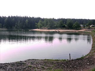
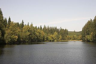
The Teufelsteich was one of the oldest reservoirs in the Harz Mountains of central Germany.
It was built in 1697 near Harzgerode and Quedlinburg (in the present state of Saxony-Anhalt) for mining purposes. In 1837/38 it was raised to support silver mining.
The Teufelsteich was first linked to the Lower Harz Pond and Ditch System in 1903/04. The Kochsgraben was extended for the last time and it now ended in the catchment area of the Teufelsteich, the Siebengrund bottom. This extension was called the Siebengründer Graben; at the same time the section to Neudorf was drained dry. The Teufelsteich was now supplied with water from the Lude stream and the Rödelbachgraben along with the nearby mining ponds of the Fürstenteich and the Silberhütter Pochwerksteich.
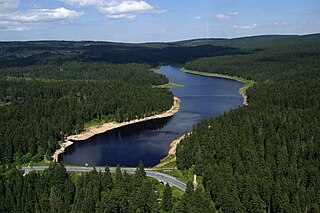
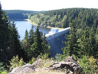
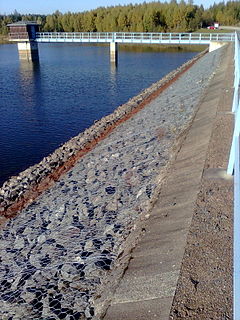
In 1947 the pond was used for the first time to supply drinking water. In 1985 the embankment had to be completely replaced. To do this a new dam was built 30 m below the old one and the old dam removed.
The new, higher dam consists of a shale body with a clay core in the centre. The retaining capacity of the new dam is around 203,000 m³ greater. The reservoir now has new facilities such as a spillway, a bottom outlet, a glory hole spillway (Entnahmeturm) with service jetty, a valve house and a pump station. The impounded stream is the Teufelsgrundbach.
Talsperren in Sachsen-Anhalt, Autorenkollegium, Hrsg.: Talsperrenmeisterei des Landes Sachsen-Anhalt, 1994
Related Research Articles
The Birnbaumteich is a reservoir in the German state of Saxony-Anhalt, located near Neudorf in the Harz mountains.
The Mandelholz Dam holds back the Kalte Bode Flood Control Basin which is a flood protection reservoir located between the villages of Elend and Königshütte near Wernigerode in the Harz mountains of Germany. It impounds the waters of the Kalte Bode when water levels are high.
The Innerste Dam is a dam on the Innerste river, which lies near Langelsheim and Wolfshagen in the Harz mountains. It was built between 1963 and 1966 and belongs to the Harzwasserwerke. Its purposes are the supply of drinking water, flood protection, water flow regulation and hydroelectric power generation. The average annual discharge through the Innerste Dam is 60 million m³.
The Oderteich is an historic reservoir about seven kilometres northeast of Sankt Andreasberg in the Upper Harz in central Germany. It was built by miners from St. Andreasberg in the years 1715 to 1722 and, today, is an important component of the water supply network known as the Upper Harz Water Regale. Moreover, for 170 years, from the time it was completed to the end of the 19th century, the Oderteich had the largest dam in Germany. The dam lies at a height of 725 m above NN by the B 242 federal highway, about a kilometre west of its intersection with the B 4.
The Upper Harz Ponds are found mainly around the mining town of Clausthal-Zellerfeld and the nearby villages of Buntenbock and Hahnenklee in the Upper Harz mountains of central Germany. There are around 70 ponds in total, both large and small. They were built by the miners of the Upper Harz, mostly between the 16th and 18th centuries, and are important components of the cultural monument known as the Upper Harz Water Regale - a network of dams, ditches, ponds and tunnels that was built to supply much-needed water power for the mining industry in the Harz mountains. Today the Water Regale is being proposed as a UNESCO World Heritage Site. About half the dammed ponds are classified today as reservoirs, but they have now become characteristic features of the Upper Harz and are home to some extremely rare plant and animal species.
The Zillierbach Dam lies in the East Harz in the German state of Saxony-Anhalt near the town of Elbingerode (Harz) and impounds the Zillierbach stream. It supplies drinking water to several villages in the High Harz as well as the town of Wernigerode; it also provides flood protection.
The Königshütte Dam is a dam in the German state of Saxony-Anhalt in the Harz mountains. It impounds the River Bode and lies between Königshütte and Susenburg. It is a so-called storage reservoir (Überleitungssperre) forming part of the Rappbode Dam system.
The Upper Harz Water Regale is a system of dams, reservoirs, ditches and other structures, much of which was built from the 16th to 19th centuries to divert and store the water that drove the water wheels of the mines in the Upper Harz region of Germany. The term regale, here, refers to the granting of royal privileges or rights in this case to permit the use of water for mining operations in the Harz mountains of Germany.
The Wendefurth Dam near Wendefurth in the Harz is one of the dams downstream of the Rappbode Dam, that provides flood protection as well as impounding the River Bode to provide the lower reservoir for the Wendefurth Power Station. In addition it is a bathing lake and also supports fish farming.
The Rappbode Auxiliary Dam is one of the two auxiliary dams in the Rappbode Dam system. This is the heart of the Rappbode Dam system in the East Harz, which is operated by the Saxony-Anhalt Dam Company and which also includes the Hassel Auxiliary Dam and the Königshütte, Mandelholz and Wendefurth dams.
The Silberteich is a man-made reservoir, of a type called a Kunstteich, and lies on the upper reaches of the Brunnenbach stream between Braunlage and Sankt Andreasberg in the Harz Mountains of Germany. It was built as part of the historic Upper Harz Water Regale.
Silberhütte is a village in the town of Harzgerode in the district of Harz in the German state of Saxony-Anhalt. Its name means "silver works", a place where silver ore is smelted.
The Kiliansteich is one of the oldest reservoirs in Germany. The reservoir is located near Straßberg (Harz) in the German state of Saxony-Anhalt and supplies drinking water. It impounds the Büschengraben stream. The lake is part of the heritage area (Flächendenkmal) of the Lower Harz Pond and Ditch System.
Within the Lower Harz region are still many traces of the historical water management facilities used by the mining industry. In addition to water-carrying ditches and ponds, there are also long-abandoned ditches and dry pond beds. The Lower Harz Pond and Ditch System, which forms the major part of these old water management facilities, lies in the central Lower Harz, almost entirely within the borough of the present-day town of Harzgerode.
The Frankenteich is an old reservoir in the Harz Mountains of central Germany. It was constructed in 1716 under the direction of mining director (Bergwerksdirektor), Christian Zacharias Koch, for the mining industry and is the largest pond in the Lower Harz. Since 1901 it has supplied drinking water to the village of Straßberg. It impounds the Rödelbachgraben, which discharges into the Selke in Straßberg. A mining ditch runs past the foot of the dam from the Kiliansteich which, like the Frankenteich, belongs to the heritage area designated as the Lower Harz Pond and Ditch System.
The Siebengründer Graben is a mining ditch, constructed in 1903/1904 in the Lower Harz in central Germany, that is dry and no longer used.
The Rödelbachgraben, usually called the Rödelbach and also incorrectly referred to as the Rieschengraben, is a river of Saxony-Anhalt, Germany.
The Fürstenteich is a reservoir near Silberhütte in the German state of Saxony-Anhalt. It has an earth-filled dam with an impervious core. It impounds the Teufelsgrundbach stream.
The Bergrat Müller Pond, named after a former mining director, Müller, in the Harz mountains of central Germany is a storage pond laid out from 1737 to 1738. It has an area of about 1.3 ha and lies in the forested southern part of the borough of Quedlinburg in the county of Harz in Saxony-Anhalt.
This page is based on this Wikipedia article Text is available under the CC BY-SA 4.0 license; additional terms may apply. Images, videos and audio are available under their respective licenses.