
Hawick is a town in the Scottish Borders council area and historic county of Roxburghshire in the east Southern Uplands of Scotland. It is 10 miles (16.1 km) south-west of Jedburgh and 8.9 miles (14.3 km) south-south-east of Selkirk. It is one of the furthest towns from the sea in Scotland, in the heart of Teviotdale, and is the biggest town in Roxburghshire. The town is at the confluence of the Slitrig Water with the River Teviot.

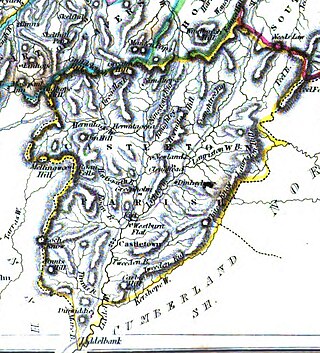
Roxburghshire or the County of Roxburgh is a historic county and registration county in the Southern Uplands of Scotland. It borders Dumfriesshire to the west, Selkirkshire and Midlothian to the northwest, and Berwickshire to the north. To the southwest it borders Cumberland and to the southeast Northumberland, both in England.
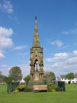
Jean Elliot, also known as Jane Elliot, was a Scottish poet. She wrote one of the most famous versions of The Flowers of the Forest, a song lamenting the Scottish army's defeat in the Battle of Flodden. Published in 1776, it is her only surviving work. The lyrics are set to an earlier tune c. 1615–1625 in the John Skene of Halyards Manuscript as "Flowres of the Forrest."

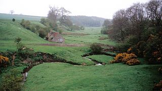
The River Teviot, or Teviot Water, is a river of the Scottish Borders area of Scotland, and is the largest tributary of the River Tweed by catchment area. The Teviot is an important river for wildlife, especially the Atlantic salmon, but in recent years has witnessed at least four extreme flooding events.
The Catrail is a linear earthwork in Roxburghshire, southern Scotland. It runs from Robert's Linn, a burn (stream) flowing into the Slitrig Water, westward and north-westward to the head of the Dean Burn, a tributary of the Borthwick Water. It is about 11.5 mi (18.5 km) long, and consists of a ditch and bank. The Deil's Dyke was once considered to extend to the Catrail.
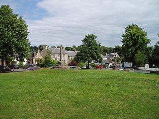
Denholm is a small village located between Jedburgh and Hawick in the Scottish Borders region of Scotland, UK. The estimated population of Denholm is 600. There is a village green in the centre. It lies in the valley of the River Teviot. Denholm is a Conservation Area listed as 'a planned village as opposed to the traditional unplanned or organic form of village usually found in Roxburghshire.'

Nisbet is a small hamlet on the B6400, in Roxburghshire, along the River Teviot, in the Scottish Borders area of Scotland. It is located 5.5 kilometres (3.4 mi) north of Jedburgh and 5 kilometres (3.1 mi) south of Roxburgh.
Cessford Burn is a small stream which eventually runs to meet the Kale Water and then joins the River Teviot, finally entering the River Tweed at Kelso, Scotland.
Ancrum is a village in the Borders area of Scotland, 5 km (3.1 mi) northwest of Jedburgh.

Teviothead is a small village and civil parish in Teviotdale in the Scottish Borders, known locally as Teviotheid. It is located south of the River Teviot.

Branxholme is a hamlet in the Scottish Borders area of Scotland, overlooking the River Teviot, three miles southwest of Hawick, on the A7 road to Langholm.

The Teviot Falls is a plunge waterfall in the Darling Downs region of Queensland, Australia.

Bedrule is a hamlet and civil parish in the historic county of Roxburghshire in the Scottish Borders area of Scotland. The hamlet lies on the east side of the Rule Water, which gave the village its name, about 4 miles west of Jedburgh. It lies south of the A698 between Hawick and Jedburgh. Other local place-names based on the river include Hallrule, Abbotrule, Ruletownhead and Spittal-on-Rule. Larger settlements include Bonchester Bridge and Denholm, as well as Hawick and Jedburgh.

Rubers Law is a prominent, conical hill in the Scottish Borders area of south-east Scotland. It stands on the south bank of the River Teviot, between the towns of Hawick and Jedburgh, and south of the village of Denholm. The hill is on the border between the historic parishes of Cavers and Hobkirk, and until 1975 it stood within the historic county of Roxburghshire.
Castleton is a civil parish in the Scottish Borders area of Scotland, in the former Roxburghshire, in the extreme south of the Borders area. It is bounded by Northumberland (England), Dumfries and Galloway, and the parishes of Hobkirk, Southdean and Teviothead. The village of Castleton was commenced in 1793. It was built as a result of the land clearances in the 1790s when people were forced to move from Old Castleton village. While the parish retained the name Castleton, the village later became identified as New Castleton or Newcastleton. The parish is also known by its older name Liddesdale

Crailing is a village on the A698, in Teviotdale, 4m east of Jedburgh in the Scottish Borders area of Scotland, in the historic county of Roxburghshire.
Archibald Douglas, 13th of Cavers was a Scottish politician. In 1701, prior to the Union of Scotland and England, Douglas had been able to return himself as one of Roxburghshire's four Commissioners to the Scottish Parliament. In his electoral capacity, he consistently opposed the Roxburghe interest both in the Scottish and British Parliaments. Repeated successes prompted his son William to remark with pardonable exaggeration in 1712 that "you have it in your hands to make the Member for the county."

Teviot Brook is a waterway in South East Queensland, Australia. It rises in the Main Range at Carneys Creek and joins the Logan River at Cedar Grove. It is part of the Clarence Moreton Basin, a sedimentary basin on the easternmost part of the Australian continent.
The West Teviotdale Open or West Teviotdale (Hawick) Open was a late Victorian era men's and women's grass court tennis tournament played at the Hawick Cricket Ground, Hawick, Teviotdale, Roxburghshire, Scotland The tournament was first staged in August 1883. It was held annually as an all comers open event until 1887.