A geographic information system (GIS) consists of integrated computer hardware and software that store, manage, analyze, edit, output, and visualize geographic data. Much of this often happens within a spatial database, however, this is not essential to meet the definition of a GIS. In a broader sense, one may consider such a system also to include human users and support staff, procedures and workflows, the body of knowledge of relevant concepts and methods, and institutional organizations.

Lamar Institute of Technology (LIT) is a public technical school in Beaumont, Texas. LIT was formerly a part of Lamar University, but became a separate institution when the university joined the Texas State University System in 1995.

The Kansas Geological Survey (KGS) is a research and service division of the University of Kansas, charged by statute with studying and providing information on the geologic resources of Kansas. The KGS has no regulatory authority and does not take positions on natural resource issues.

The Texas Historical Commission is an agency dedicated to historic preservation within the U.S. state of Texas. It administers the National Register of Historic Places for sites in Texas.
GIS or Geographic Information Systems has been an important tool in archaeology since the early 1990s. Indeed, archaeologists were early adopters, users, and developers of GIS and GIScience, Geographic Information Science. The combination of GIS and archaeology has been considered a perfect match, since archaeology often involves the study of the spatial dimension of human behavior over time, and all archaeology carries a spatial component.

The Texas Department of Transportation is a Texas state government agency responsible for construction and maintenance of the state's immense state highway system and the support of the state's maritime, aviation, rail, and public transportation systems. TxDOT previously administered vehicle registration prior to the creation of the Texas Department of Motor Vehicles in November 2009.
Pennsylvania Spatial Data Access (PASDA) is Pennsylvania's official public access geospatial information clearinghouse. PASDA serves as Pennsylvania's node on the National Spatial Data Infrastructure (NSDI). PASDA is a cooperative effort of the Pennsylvania Geospatial Technologies Office of the Office of Information Technology and the Pennsylvania State University Institute of Energy and the Environment.

The Texas Commission on Environmental Quality (TCEQ) is the environmental agency for the state of Texas. The commission's headquarters are located at 12100 Park 35 Circle in Austin. The fourth-largest environmental agency in the United States, it employs about 2,780 employees, has 16 regional offices, and has a $420 million operating budget for the 2016 fiscal year.
The Utah Geological Survey is based in Salt Lake City, Utah, United States. It also has an office in Cedar City, Utah.

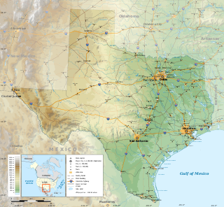
The geography of Texas is diverse and large. Occupying about 7% of the total water and land area of the U.S., it is the second largest state after Alaska, and is the southernmost part of the Great Plains, which end in the south against the folded Sierra Madre Oriental of Mexico. Texas is in the South Central United States of America, and is considered to form part of the U.S. South and also part of the U.S. Southwest.

The Texas Parks & Wildlife Department (TPWD) is a Texas state agency that oversees and protects wildlife and their habitats. In addition, the agency is responsible for managing the state's parks and historical areas. Its mission is to manage and conserve the natural and cultural resources of Texas and to provide hunting, fishing, and outdoor recreation opportunities for the use and enjoyment of present and future generations.
Geospatial metadata is a type of metadata applicable to geographic data and information. Such objects may be stored in a geographic information system (GIS) or may simply be documents, data-sets, images or other objects, services, or related items that exist in some other native environment but whose features may be appropriate to describe in a (geographic) metadata catalog.

The Philippines' National Mapping and Resource Information Authority, abbreviated as NAMRIA, is an agency of the Philippine government under the Department of Environment and Natural Resources responsible for providing the public with mapmaking services and acting as the central mapping agency, depository, and distribution facility of natural resources data in the form of maps, charts, texts, and statistics.
The Arizona Geographic Information Council (AGIC) was established by executive order as Arizona's primary forum and oversight group for coordination efforts related to geographic information systems (GIS). AGIC identifies standards and implementation strategies to provide a framework for optimizing Arizona's investment in GIS. Through cooperation and partnerships, AGIC facilitates the acquisition, exchange and management of geospatial data and technology to benefit State agencies and the Arizona GIS community. AGIC meets on a regular basis and conducts an Annual GIS Conference to address statewide GIS issues, requirements and solutions.

Geographic Information Systems (GIS) has become an integral part of aquatic science and limnology. Water by its very nature is dynamic. Features associated with water are thus ever-changing. To be able to keep up with these changes, technological advancements have given scientists methods to enhance all aspects of scientific investigation, from satellite tracking of wildlife to computer mapping of habitats. Agencies like the US Geological Survey, US Fish and Wildlife Service as well as other federal and state agencies are utilizing GIS to aid in their conservation efforts.
Geographic Information Systems (GIS) are an increasingly important component of business, healthcare, security, government, trade, media, transportation and tourism industries and operations in China. GIS software is playing an increasing role in the way Chinese companies analyze and manage business operations.

The United States Geological Survey (USGS), founded as the Geological Survey, is an agency of the United States government whose work spans the disciplines of biology, geography, geology, and hydrology. The agency was founded on March 3, 1879, to study the landscape of the United States, its natural resources, and the natural hazards that threaten it. The agency also makes maps of extraterrestrial planets and moons based on data from U.S. space probes.
The Michigan Department of Technology, Management & Budget (DTMB), formerly Michigan Department of Management and Budget, is a principal department of the government of Michigan responsible for various support functions within the government.
The Texas Juvenile Justice Department (TJJD) is a state agency in Texas, headquartered in the Central Services Building (CSB) in Austin.
The Prairie Research Institute is a multidisciplinary research institute charged with providing objective research, expertise, and data on the natural and cultural resources of Illinois. It was established as a unit of the University of Illinois at Urbana-Champaign by a Public Act of the Illinois State Legislature in 2008. The institute comprises four state scientific surveys: the Illinois Natural History Survey (INHS), the Illinois State Archaeological Survey (ISAS), the Illinois State Geological Survey (ISGS), and the Illinois State Water Survey (ISWS), and the institute also houses the Illinois Sustainable Technology Center (ISTC). The institute has a combined total staff of more than 700 employees, with facilities located on the Urbana-Champaign campus of the University of Illinois, and field offices and research stations throughout the state.


