
Namakkal is a special grade municipality and the headquarters of Namakkal district in the Indian state of Tamil Nadu. It is the first ISO 14001-2004 certified municipality in Asia for environmental management, specifically the provision and maintenance of water supply, solid waste and sewage management, town planning, lighting and other social services. Namakkal is known as the Egg City due to its large egg production and Transport city.

Kodaikanal is a hill station which is located in Dindigul district in the state of Tamil Nadu, India. Its name in the Tamil language means "The Gift of the Forest". Kodaikanal is referred to as the "Princess of Hill stations" and has a long history as a retreat and tourist destination.

The Palani Hills are a mountain range in the southern Indian states of Kerala and Tamil Nadu. The Palani Hills are an eastward extension of the Western Ghats ranges, which run parallel to the west coast of India. The Palani Hills adjoin with the high Anamalai range on the west and extend east into the plains of Tamil Nadu, covering an area of 2,068 square kilometres (798 sq mi). The highest part of the range is in the southwest, and reaches 1,800-2,500 metres elevation; the eastern extension of the range is made up of hills 1,000-1,500 m (3,281-4,921 ft) high.
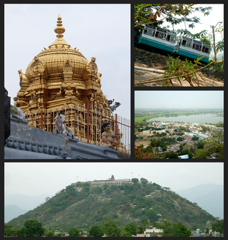
Palani (Tamil: [paɻani] or Palnias in British records, is a town and a taluk headquarters in Dindigul district of the western part of Tamil Nadu state in India. It is located about 106 kilometres south-east of Coimbatore and 122 kilometres north-west of Madurai, 67 kilometres from Kodaikanal. The Palani Murugan Temple or Arulmigu Dhandayuthapani Swamy Temple, dedicated to Murugan is situated on a hill overlooking the town. The temple is visited by more than 7 million pilgrims each year. As of 2011, the town had a population of 126,751 which makes it the second largest town in the district after Dindigul.

Dindigul District is one of the 38 districts in the state of Tamil Nadu in India. Dindigul District is the second largest district in Tamil Nadu by area after Thiruvannamalai District. The district was carved out of Madurai District in 1985. It has an area of 6266.64 km2 and comprises 3 revenue divisions, 10 taluks, and 14 panchayat unions. The district is bound by Tiruppur district in the northwest, Karur district in the north, Tiruchirappalli district in the northeast, Madurai and Theni districts in the south, and Idukki district of Kerala to the west. As of 2011, the district had a population of 2,159,775 with a sex-ratio of 998 females for every 1,000 males.
Ayakudi is a panchayat town in Dindigul district in the state of Tamil Nadu, India. Ayakudi is thought to be the place where the kings of Ay Kingdom originated. The city is known for guava. It is filled with nature in the slopes of Kodaikanal.
Chennimalai is a town in Erode district, Tamil Nadu, India. It is popularly known as the 'Handloom Town'.

Oddanchatram is a town in Dindigul district in the Indian state of Tamil Nadu. Oddanchatram is a region in the southwest of Tamil Nadu. The Town was carved out of Madurai District in 1985. Oddanchatram is also famous for vegetable and cattle market. As of 2011, the town had a population of 30,064. It is known as vegetable city of Tamil Nadu. Oddanchatram vegetable market is the largest supplying of vegetables in Tamilnadu and Kerala. Agriculture is the major economic support for the town.
Keeranur 624617 is a panchayat town in Dindigul district in the Indian state of Tamil Nadu. It is situated between Palani and Dharapuram. There are more than three places in Tamil Nadu and in the rest of India with the same name, a bigger Keeranur situated near Trichy.
Pattiveeranpatti is a panchayat town in Dindigul district in the Indian state of Tamil Nadu.
The Palani Hills Wildlife Sanctuary and National Park is a proposed protected area in Dindigul District, Tamil Nadu India. The park will be an upgrade and expansion of the 736.87 km2(PRO) Palani (Kodaikanal) Wildlife Sanctuary which was to be established in 2008. The park includes about 36% of the 2,068 square kilometres (798 sq mi) in the Palani Hills. The park is located between latitude 10°7'–10°28' N and longitude 77°16'–77°46' E. Central location is 1.5 kilometres (0.93 mi) east northeast of Silver Cascade Waterfall and 4 kilometres (2.5 mi) E X NE of Kodaikanal Lake.

Vilpatti is a Panchayat in Kodaikanal Taluk of Dindigul district, Tamil Nadu state, South India. It is composed of the main village of Vilpatti and 11 hamlets. Main Vilpatti village is 9 km North of Kodaikanal town, but hamlets within its administration extend to the Palani ghat road. It is an agricultural area with the primary crops of potatoes, carrot, coffee and bananas.

Poombarai is a village in the Indian state of Tamil Nadu.

Mother Teresa Women's University, a state university of the Government of Tamil Nadu, is situated at Kodaikanal, in the Palani hills of South India. It was established in the year 1984 by the enactment of Tamil Nadu Act 15. This university aims to extend its service to women students of all communities. It strives for Academic Excellence and Personality Development and gives equal importance for promotion of employment prospects to young girls. It monitors and offers consultancy services and research in Women's Studies.

Kodaikanal Lake, also known as Kodai Lake, is a manmade lake located in the Kodaikanal city in Dindigul district in Tamil Nadu, India. Sir Vere Henry Levinge, the then Collector of Madurai, was instrumental in creating the lake in 1863, amidst the Kodaikanal town which was developed by the British and early missionaries from USA. The lake is said to be Kodaikanal's most popular geographic landmark and tourist attraction.
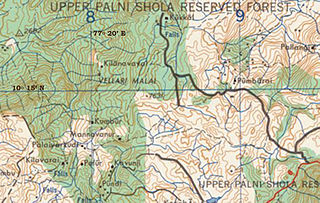
Kilanavayal (Keelanavayal) is a small village of terrace farmers in Mannavanur panchayat at the far eastern end of the Manjampatti Valley drainage basin in the Palani Hills. There is a 9 kilometers (5.6 mi) road between Mannavanur and Kilanavayal. There is a trekking route from Mannavanur via Keelanavayal to ManjampattI and Thalinji. It is in Kodaikanal block of Dindigul district, Tamil Nadu state, India. Altitude is 1,755 meters (5,758 ft) at: 10°15′53″N77°19′40″E.
Kodaikanal is a city and a Taluk division of Dindigul district in the state of Tamil Nadu, India.
Kookal is a Panchayat village of terrace farmers at the far western end of the Palani Hills in Kodaikanal block of Dindigul district, Tamil Nadu state, South India. It is 40 kilometres (25 mi) from Kodaikanal at: 10°17′9″N77°21′48″E. Elevation is 1,890 metres (6,200 ft). Kookal is notable for the high biodiversity of the area.
Andipatti taluk is a taluk of Theni district of the Indian state of Tamil Nadu. The headquarters of the taluk is the town of Andipatti.

Uthiyur is a small town in Kangeyam taluk of Tiruppur district in south Indian state of Tamil Nadu.