Transport in China has experienced major growth and expansion in recent years. Although China's transport system comprises a vast network of transport nodes across its huge territory, the nodes tend to concentrate in the more economically developed coastal areas and inland cities along major rivers. The physical state and comprehensiveness of China's transport infrastructure tend to vary widely by geography. While remote, rural areas still largely depend on non-mechanized means of transport, urban areas boast a wide variety of modern options, including a maglev system connecting the city center of Shanghai with Shanghai Pudong International Airport. Airports, roads, and railway construction will provide a massive employment boost in China over the next decade.
The Ob is a major river in Russia. It is in western Siberia, and with its tributary the Irtysh forms the world's seventh-longest river system, at 5,410 kilometres (3,360 mi). The Ob forms at the confluence of the Biya and Katun which have their origins in the Altai Mountains. It is the westernmost of the three great Siberian rivers that flow into the Arctic Ocean. Its flow is north-westward, then northward.

The Salween is a Southeast Asian river, about 3,289 km (2,044 mi) long, flowing from the Tibetan Plateau south into the Andaman Sea. The Salween flows primarily within southwest China and eastern Myanmar (Burma), with a short section forming the border of Burma and Thailand. Throughout most of its course, it runs swiftly through rugged mountain canyons. Despite the river's great length, only the last 90 km (56 mi) are navigable, where it forms a modest estuary and delta at Mawlamyine. The river is known by various names along its course, including the Thanlwin in Burma and the Nu Jiang in China. The commonly used spelling "Salween" is an anglicisation of the Burmese name dating from 19th-century British maps.

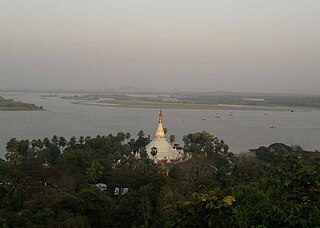
Mawlamyine, formerly Moulmein, is the fourth-largest city in Myanmar (Burma), 300 kilometres (190 mi) south east of Yangon and 70 kilometres (43 mi) south of Thaton, at the mouth of Thanlwin (Salween) River. Mawlamyine was an ancient city and the first capital of British Burma. The city is currently the capital and largest city of Mon State and the main trading centre and seaport in south eastern Myanmar.
Mottama is a town in the Thaton District of Mon State, Myanmar. Located on the west bank of the Thanlwin river (Salween), on the opposite side of Mawlamyaing, Mottama was the capital of the Martaban Kingdom from 1287 to 1364, and an entrepôt of international repute until the mid-16th century.

The Irrawaddy River is the largest river in Myanmar. Originating from the confluence of the N'mai and Mali rivers, it flows from north to south before emptying through the Irrawaddy Delta in the Ayeyarwady Region into the Andaman Sea. Its drainage basin of about 404,000 square kilometres (156,000 sq mi) covers 61% of the land area of Burma, and contains five of its largest cities.

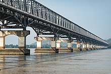
The Godavari Bridge or Kovvur–Rajahmundry Bridge is a truss bridge spanning the Godavari River in Rajahmundry, India. It is India's fourth longest road-cum-rail bridge crossing a water body, the first one being the Bogibeel Bridge over the Brahmaputra in Assam, and second is Digha–Sonpur Bridge over the Ganga in Bihar.

Mawlamyine University, located in Mawlamyine, is the largest university in Mon State, Myanmar. Being established in 1953, Mawlamyine University is the third oldest Arts and Science university in the country after Yangon University and Mandalay University. The university offers bachelor's and master's degree programs in liberal arts and sciences. It is one of the few universities in the country to offer a specialization in marine science.

Ye is a town in the southern end of Mon State, Myanmar (Burma). It is the principal town of Ye Township of Mawlamyine District. The town is located by the Ye River as it drains into the Gulf of Martaban, and is surrounded by Tenasserim Hills in the east. It has warm, moderate weather. The town's economy is mainly based on betel nut, rubber, fishery production, and trade. Ye is on the Mawlamyaing-Dawei rail line, and has a seaport. The majority of the people are ethnic Mon people. Ye is a center of Mon language education. As of 2014, it had a population of 34,430.
The transportation system of Georgia is a cooperation of complex systems of infrastructure comprising over 1,200 miles (1,900 km) of interstates and more than 120 airports and airbases serving a regional population of 59,425 people.
Rail transport in Myanmar began in 1877. Three private rail companies were nationalised nineteen years later. During the Japanese occupation of Burma, Allied prisoners of war were forced to build the Burma Railway. Myanmar Railways has expanded its network somewhat since 1988.

Rail transport in Myanmar consists of a 6,207.644 km (3,857 mi) railway network with 960 stations. The network, generally spanning north to south with branch lines to the east and west, is the second largest in Southeast Asia, and includes the Yangon Circular Railway which serves as a commuter railway for Yangon, the principal commercial city in Myanmar. The quality of the railway infrastructure is generally poor. The tracks are in poor condition, and are not passable during the monsoon season. The speed of freight trains is heavily restricted on all existing links as a consequence of poor track and bridge conditions. The maximum speed for freight trains has been quoted as 24 km/h (15 mph), suggesting that commercial speeds on this section could be as low as 12–14 km/h (7.5–8.7 mph).

Mawlamyine railway station is a railway station located in Mawlamyine, Mon State, Myanmar on Myanmar Railways' Bago-Mawlamyine-Dawei line. The two-story station is 290 feet (88 m) long and 110 feet (34 m) wide, and has a total floor area of 638,000 square feet.

The Amur–Yakutsk Mainline, abbreviated to AYaM, is a partially complete railway in eastern Russia, linking the Trans–Siberian Railway and Baikal–Amur Mainline with the Sakha Republic.

Tanintharyi Line is a 1,000 mm gauge railway line in Myanmar's southernmost region, Tanintharyi Region, operated by Myanma Railways. The line runs from Mawlamyine Railway Station (Moulmein) to the Dawei area, with connections to Yangon Central Railway Station, it is under construction extending towards Myeik from the current terminus of Thayetchaung Station, which lies just after Dawei Station. Current section in operation includes the part from Mawlamyaing Station to Thayetchaung. It is expected to become a part of a pan-Asian railway network, allowing spur connections specifically to Thailand. A spur connection between the SRT rail head at Nam Tok railway station in Kanchanaburi Province to Dawei Station through mountains is planned by Thai interests backed by Japanese funding, though other rail connections are certainly possible.
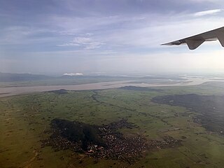
Bilu Island is a Deltaic island of the Salween (Thanlwin) River in Chaungzon Township, Mon State, located west of Mawlamyine. The island is roughly the size of Singapore, and inhabited by 200,000 people.

Mon State is an administrative division of Myanmar. It lies between Kayin State to the east, the Andaman Sea to the west, Bago Region to the north and Tanintharyi Region to the south, also having a short border with Thailand's Kanchanaburi Province at its south-eastern tip. The land area is 12,155 km2 (4,693 sq mi). The Dawna Range, running along the eastern side of the state in a NNW–SSE direction, forms a natural border with Kayin State. Mon State includes some small islands, such as Kalegauk, Wa Kyun and Kyungyi Island, along its 566 km (352 mi) of coastline. The state's capital is Mawlamyine.

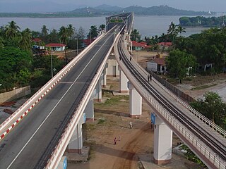
The Bogyoke Aung San bridge is a bridge crossing over the Thanlwin River in Mawlamyine, Myanmar and connects Mawlamyine to Chaungzon. The bridge is also known as the Bilu Kyun Bridge. It was officially opened to the public on May 9, 2017.
Yangon–Mawlamyine Railway is a railway line in Myanmar and is operated by Myanma Railways.