The Central Artery/Tunnel Project, commonly known as the Big Dig, was a megaproject in Boston that rerouted the Central Artery of Interstate 93 (I-93), the chief highway through the heart of the city, into the 1.5-mile (2.4 km) tunnel named the Thomas P. O'Neill Jr. Tunnel. The project also included the construction of the Ted Williams Tunnel, the Leonard P. Zakim Bunker Hill Memorial Bridge over the Charles River, and the Rose Kennedy Greenway in the space vacated by the previous I-93 elevated roadway. Initially, the plan was also to include a rail connection between Boston's two major train terminals. Planning began in 1982; the construction work was carried out between 1991 and 2006; and the project concluded on December 31, 2007, when the partnership between the program manager and the Massachusetts Turnpike Authority ended.

State Route 1 (SR 1) is a major north–south state highway that runs along most of the Pacific coastline of the U.S. state of California. At 656 miles (1,056 km), it is the longest state route in California, and the second-longest in the US after Montana Highway 200. SR 1 has several portions designated as either Pacific Coast Highway (PCH), Cabrillo Highway, Shoreline Highway, or Coast Highway. Its southern terminus is at Interstate 5 (I-5) near Dana Point in Orange County and its northern terminus is at U.S. Route 101 (US 101) near Leggett in Mendocino County. SR 1 also at times runs concurrently with US 101, most notably through a 54-mile (87 km) stretch in Ventura and Santa Barbara counties, and across the Golden Gate Bridge.

Big Horn County is a county in the U.S. state of Wyoming. As of the 2020 United States Census, the population was 11,521. The county seat is Basin. Its north boundary abuts the south boundary of Montana.
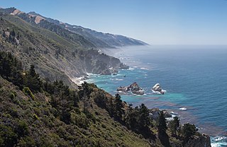
Big Sur is a rugged and mountainous section of the Central Coast of California between Carmel and San Simeon, where the Santa Lucia Mountains rise abruptly from the Pacific Ocean. It is frequently praised for its dramatic scenery. Big Sur has been called the "longest and most scenic stretch of undeveloped coastline in the contiguous United States", a sublime "national treasure that demands extraordinary procedures to protect it from development", and "one of the most beautiful coastlines anywhere in the world, an isolated stretch of road, mythic in reputation". The views, redwood forests, hiking, beaches, and other recreational opportunities have made Big Sur a popular destination for visitors from across the world. With 4.5 to 7 million visitors annually, it is among the top tourist destinations in the United States, comparable to Yosemite National Park, but with considerably fewer services, parking, roads, and related infrastructure.

Big Bear Lake is a reservoir in the San Bernardino Mountains, in San Bernardino County, California, United States. It is a snow and rain fed lake, having no other means of tributaries or mechanical replenishment. At a surface elevation of 6,743 ft (2,055 m), it has an east-west length of approximately 7 mi (11 km) and is approximately 2.5 mi (4.0 km) at its widest measurement, though the lake's width mostly averages a little more than 1⁄2 mi (0.8 km). These approximations are based on the lake having an optimum retainable water level. At dam's end Big Bear measures its deepest water at 72 ft (22 m).

State Route 120 is a state highway in the central part of California, connecting the San Joaquin Valley with the Sierra Nevada, Yosemite National Park, and the Mono Lake area. Its western terminus is at Interstate 5 in Lathrop, and its eastern terminus at U.S. Route 6 in Benton. While the route is signed as a contiguous route through Yosemite, the portion inside the park is federally maintained and is not included in the state route logs. The portion at Tioga Pass at Yosemite's eastern boundary is the highest paved through road in the California State Route system. This part is not maintained in the winter and is usually closed during the winter season.

The Trans-Pecos, as originally defined in 1887 by the Texas geologist Robert T. Hill, is the portion of Texas that lies west of the Pecos River. The term is considered synonymous with Far West Texas, a subdivision of West Texas. The Trans-Pecos is part of the Chihuahuan Desert, the largest desert in North America. It is the most mountainous and arid portion of the state, and most of its vast area is sparsely populated. Among the nine counties in the region are the five largest counties by area in Texas and eight of the eleven largest in the state. The area is known for the natural environment of the Big Bend and the gorge of the Rio Grande, part of which has been designated a National Wild and Scenic Rivers System. With the notable exceptions of Big Bend Ranch State Park, Big Bend National Park and the Guadalupe Mountains National Park, the vast majority of the Trans-Pecos region consists of privately owned ranchland. However, most of the region's population reside in the El Paso metropolitan area.
Highway 695 is a highway in the Canadian province of Saskatchewan. It runs from Highway 3 to Highway 793 near Victoire. Highway 695 is about 28 km (17 mi.) long.
Highway 793 is a provincial highway in the Canadian province of Saskatchewan. It runs from Highway 24 to Highway 55. Highway 793 is about 51 km (32 mi.) long.
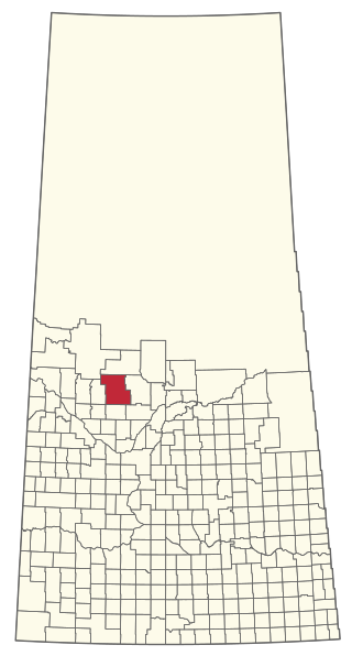
The Rural Municipality of Spiritwood No. 496 is a rural municipality (RM) in the Canadian province of Saskatchewan within Census Division No. 16 and SARM Division No. 6. Located in the north-central portion of the province, it is west of the City of Prince Albert.
Highway 623 is a highway in the Canadian province of Saskatchewan. It runs from the Highway 13 near Ogema to Highway 334. Highway 623 is about 45 km (28 mi.) long.
Highway 20 is a major road intended for travel by the public between Highway 11 Lumsden to Highway 3 at Birch Hills. Saskatchewan's main roadways are located in the central/southern geographical land area of rolling prairie and grass land in a western Canadian prairie province. This highway is one which runs south to north and is located just east of Saskatoon and just north of Regina. At the northern extremity near Lanigan, the highway helps to service the PCS Lanigan potash mining operation. Down south, the highway is popular for tourists heading out to the Qu'Appelle Valley and resorts and beaches of Last Mountain Lake.
Highway 34 designates major roads intended for travel by the public between Highway 13 just to the west of Ogema to the US border. The highway used to connect to Montana Secondary Highway 511 at the Port of Big Beaver, however the port closed in 2011. Saskatchewan's main roadways are located in the central/southern geographical land area of rugged badlands, and rolling prairie and grass land in a western Canadian prairie province. This paved highway along with Red Coat Trail and Outlaw Tail, early Red river cart trails encompassed the Big Muddy Badlands.
Highway 49 and Provincial Trunk Highway 49 is a highway in the east central portion of the Canadian province of Saskatchewan and a very short highway in province of Manitoba. It runs from Saskatchewan Highway 35 between the communities of Fosston and Hendon to the Saskatchewan – Manitoba border, before ending at Provincial Trunk Highway 83 south of the community of Benito. The combined highway is about 166.4 km (103.4 mi) in length, 165.2 km (102.7 mi) is in Saskatchewan and 1.2 km (0.7 mi) is in Manitoba.

Julia Pfeiffer Burns State Park is a state park in California, 12 miles south of Pfeiffer Big Sur State Park on California's Pacific coast. A main feature of the park is McWay Falls, which drops over a cliff of 80 feet (24 m) into the Pacific Ocean. The park is also home to 300-foot (90 m) redwoods which are over 2,500 years old. The park is named after Julia Pfeiffer Burns, a respected resident and rancher in the Big Sur region in the early 20th century, who lived in the area for much of her life until her death in 1928. The 3,762-acre (1,522 ha) park was established in 1962.
Highway 709 is a highway in the Canadian province of Saskatchewan. It runs from Highway 48 near Kipling to Highway 600.
Big Sur Coast Highway is a section of California State Route 1 through the Big Sur region of California that is widely considered to be one of the most scenic driving routes in the United States, if not the world. It is both a National Scenic Highway and a California Scenic Highway, and was described by Australian painter Francis McComas as the "greatest meeting of land and water in the world". Condé Nast Traveler named State Route 1 through Big Sur one of the top ten world-famous streets, comparable to Broadway in New York City and the Champs-Élysées in Paris. The road itself is a destination for visitors.
Big River Way is a road in the Northern Rivers region of New South Wales that connects the Pacific Highway to the city of Grafton. It runs along a former section of the Pacific Highway that was bypassed by a newer alignment in 2020.