
Saint Helena is a British possession located in the South Atlantic Ocean. It consists of a remote volcanic tropical island lying some 1,950 kilometres (1,210 mi) west of the coast of southwestern Africa, and 4,000 kilometres (2,500 mi) east of Rio de Janeiro on the South American coast. It is one of three constituent parts of the British Overseas Territory of Saint Helena, Ascension and Tristan da Cunha.
Saint Helena has a known history of over 500 years since its recorded discovery by the Portuguese in 1502. Claiming to be Britain's second oldest colony, after Bermuda, this is one of the most remote settlements in the world and was for several centuries of vital strategic importance to ships sailing to Europe from Asia and South Africa. Since the early 19th century, the British occasionally used the island as a place of exile, most notably for Napoleon Bonaparte, Dinuzulu kaCetshwayo and over 5,000 Boer prisoners.
Jamestown is the capital of the British Overseas Territory of Saint Helena, Ascension and Tristan da Cunha, located on the island of Saint Helena in the South Atlantic Ocean. It is also the historic main settlement of the island and is on its north-western coast. Before the development of the port at Rupert's Bay, it was the island's only port and the centre of the island's road and communications network. It was founded when colonists from the English East India Company settled on the island in 1659 and was briefly occupied by the Dutch East India Company in 1673 before being recaptured. Many of the buildings built by the East India Company in the 1700s survive and give the town its distinctive Georgian flavour.

The Governor of Saint Helena is the representative of the British monarch in the United Kingdom's overseas territory of Saint Helena, Ascension and Tristan da Cunha. The Governor is appointed by the monarch on the official advice of Her Majesty's Government (HMG).

Half Tree Hollow is the smallest of the eight districts of the island of Saint Helena, part of the British Overseas Territory of Saint Helena, Ascension and Tristan da Cunha in the South Atlantic Ocean. It is a suburb of Jamestown and is situated at the top of Ladder Hill which forms the southern side of the James Valley, at the base of which sits Jamestown. The hill was fortified in the late 1700s and Ladder Hill Fort was subsequently built. The village grew during the 1960s because the James Valley lacked any room for expansion.

Historic Jamestown is the cultural heritage site that was the location of the 1607 James Fort and the later 17th-century town of Jamestown in America. It is located on Jamestown Island, on the James River at Jamestown, Virginia and operated as a partnership between Preservation Virginia and the U.S. National Park Service as part of Colonial National Historical Park.
Sir Edward Hay Drummond-Hay was a British naval officer, diplomat and colonial administrator.

Blue Hill is one of eight districts of the island of Saint Helena, part of the British Overseas Territory of Saint Helena, Ascension and Tristan da Cunha in the South Atlantic Ocean. It is sparsely populated and comprises the western third of the island. The district is entirely agricultural with no industrial activity.
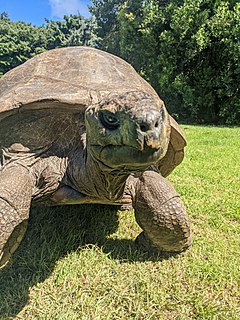
Jonathan is a Seychelles giant tortoise, a subspecies of the Aldabra giant tortoise, and is the oldest known living land animal. Jonathan resides on the island of Saint Helena, a British Overseas Territory in the South Atlantic Ocean.

Alarm Forest is the newest of the eight districts of the island of Saint Helena, part of the British Overseas Territory of Saint Helena, Ascension and Tristan da Cunha in the South Atlantic Ocean. It is located southeast of Jamestown, in the interior of the island, and is the only district to lack a coastline.
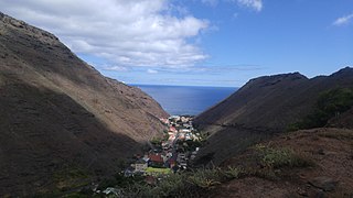
St. Paul's is one of eight districts of the island of Saint Helena, part of the British Overseas Territory of Saint Helena, Ascension and Tristan da Cunha in the South Atlantic Ocean. It is the second-most heavily populated district on the island and is located on its northwestern coast.

Saint Helena, Ascension and Tristan da Cunha is a British Overseas Territory located in the South Atlantic and consisting of the island of Saint Helena, Ascension Island and the archipelago of Tristan da Cunha including Gough Island. Its name was Saint Helena and Dependencies until 1 September 2009, when a new constitution came into force giving the three islands equal status as three territories, with a grouping under the Crown.
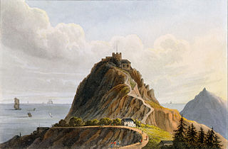
High Knoll Fort is a redoubt-style fort of the English East India Company on Saint Helena, an island and British overseas territory in the South Atlantic Ocean. High Knoll is 584 metres (1,916 ft) above sea level and is approximately one mile (1.6km) south of historic Lower Jamestown. Reopened on 18 December 2010, it is now a tourist attraction for visitors, especially those on the tourist ships that come in the summer.

The politics of Saint Helena, Ascension and Tristan da Cunha operate under the jurisdiction of the government of the United Kingdom. The three parts of the territory—Saint Helena, Ascension Island and Tristan da Cunha—effectively form an asymmetric federacy and collectively constitute one of United Kingdom's fourteen overseas territories.

Jacob's Ladder is a Grade I-listed staircase leading from Jamestown, Saint Helena, up the side of Ladder Hill to Ladder Hill Fort.
Sandy Bay is one of eight districts of the island of Saint Helena, part of the British Overseas Territory of Saint Helena, Ascension and Tristan da Cunha in the South Atlantic Ocean. Located on the island's southeastern coast, it is sparsely populated and is a popular recreation site.
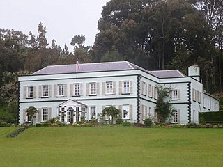
Plantation House is the official residence of the Governor of Saint Helena. It is located 3.6 km (2.2 mi) to the south of the capital, Jamestown, on the island of Saint Helena.

Saint James' Church is a church on the island of Saint Helena and is part of the Diocese of St Helena. It is situated in the capital Jamestown and is the oldest Anglican Church in the southern hemisphere; the present building was put up in 1774.
Saint FM Community Radio is a radio station serving the South Atlantic island of Saint Helena. The station is owned by Saint FM Community Radio (Guarantee) Limited, a charity company legally registered in St. Helena and limited by guarantee. The station's studios and administration offices are located at Association Hall, Main Street, Jamestown. Its membership comprises those of the island's population who wish to join.

Trade unions in Saint Helena emerged in the late 1950s in the flax industry and subsequently played a prominent role in the island's democratisation in the 1960s. The Saint Helena General Workers Union was the island's sole trade union throughout the latter half of the 20th Century. In the 21st Century, workers are mostly organised in the public sector in staff associations for nurses, teachers and public servants.

