The City Basin, Dublin

Last updated
An illustration of the new city basin taken from Charles Brooking's map of Dublin of 1728. The city bason (city basin), Dublin.jpg
An illustration of the new city basin taken from Charles Brooking's map of Dublin of 1728.

The City Basin was a public reservoir and cistern constructed near St James' Street, Dublin around 1721 to supply the City of Dublin with water. [1]

Contents

The basin had various iterations before being supplemented by the Blessington Street Basin on the North side of the city around 1810 and finally being replaced by a modern water system from Vartry Reservoir around 1869.

The basin itself was later filled in and replaced by Basin Street Flats in the 1960s and Oisín Kelly park in the 1980s. The nearby Grand Canal Harbour also fell out of use around 1960 and was filled in soon after to be finally replaced by apartments in 2023.

History

Medieval period

In 1308, it was recorded that John Le Decer, mayor or provost of Dublin, installed two public pipes for supplying the city with a fresh water source. These pipes were located at High Street and at Cornmarket and seem to have replaced an earlier water system which was already present. The source of the water was by way of a diversion of part of the Dodder at Balrothery weir near Firhouse in the southern hills of Dublin. [2]

In historical accounts, this is often referred to as the city watercourse.

Around the year 1555, a tongue was created near Kimmage to divert two thirds of the city watercourse into what was known as the Earl of Meath's watercourse combining with the River Poddle in the city proper to significantly boost the water supply. This water helped to drive early industrial development in the Liberties for breweries, tanneries and other emerging industries.

The other third of the water supply was diverted along the city watercourse proper and was carried westward at an elevated level to supply the higher parts of the city with water.

1660 improvements

In 1660, the demand for water had exceeded the supply and alterations and improvements to the watercourse and a new basin were undertaken with a subterranean course under Thomas Street to a smaller underground cistern at New Row in the Liberties. From there a 6-inch pipe went over the old bridge to supply the North side of the city.

A few years after around 1671, pipes were laid by Dublin Corporation across much of the city to supply a water source directly to streets.

1721 basin

In 1721, Dublin Corporation decided to build a more modern and extensive basin for the needs of the evolving Georgian city supplied by the River Dodder via the city watercourse as its sole original source. [3] In order to maintain water pressure in the city and effectively distribute the water it was necessary to construct a raised course through masonry and embankments through Dolphin's Barn and Kilmainham. [4] [5] [6] [7] This area is sometimes referred to as the The Back of the Pipes as a result.

James Scanlan was employed as engineer to carry out the works after an invitation which included submissions from Richard Castle and Gabriel Stokes. [8]

Around 1735, the coroporation also purchased mills and weirs at Islandbridge for £3,500 to further supplement the water supply and constructed a large mill and pump to further add to the water supply.

The area around the basin was also lined with lime and elm trees and an ornamental gate around this time and became a fashionable park for citizens of the city over the following decades. [9]

1775 improvements

City of Dublin (No. 2) Act 1775
Act of Parliament
Kingdom Ireland.svg
Long title An Act for the better regulating the pipe water of the city of Dublin.
Citation 15 & 16 Geo. 3 (1775) c. 24 (I)

In the later 18th century, water was taken from the recently constructed Grand Canal and mixed with water from the Dodder. This was undertaken by virtue of passing an act of Parliament and entering into a contract with the owners of the Grand Canal for an ample supply of water.

Later again in 1806, the corporation entered into 60 year agreements for a supply of water from both the Grand and Royal Canal on opposite side of the city. [10]

The supply of water from the Grand Canal was eventually deemed unsafe and was eventually ceased in 1869 with the resultant Vartry Reservoir developed around the same time.

Grand Canal Harbour (1785)

A harbour was completed in 1785 by the Grand Canal Company adjacent to the basin as the terminus of the completed Grand Canal. [11] It originally included two rectangular basins connected by a short canal but was later extended to include an extension with a semi-circular basin at its end.

The harbour was later supplemented with a circle line canal and the larger Grand Canal Dock constructed from around 1790-96 rather than an earlier proposal for a system of locks linking the Liffey directly from James Street. [12]

Bond harbour (1786)

In 1786 a separate rectangular spur off the first basin was completed to a new square shaped harbour by Sir James Bond, 1st Baronet on a speculative basis intending to create a separate market for produce imported from the midlands. [13] This plan was later abandoned around 1817 and later the basin was partially filled-in around 1885-86 to construct a Guinness Malt House partially using the old harbour as its private wharf for loading materials. [14] [15] This harbour remained in use until 1959.

Related Research Articles

<span class="mw-page-title-main">River Liffey</span> River in Dublin in Ireland

The River Liffey is a river in eastern Ireland that ultimately flows through the centre of Dublin to its mouth within Dublin Bay. Its major tributaries include the River Dodder, the River Poddle and the River Camac. The river supplies much of Dublin's water and supports a range of recreational activities.

<span class="mw-page-title-main">Dublin Bay</span> Inlet of the Irish Sea around Dublin, Ireland

Dublin Bay is a C-shaped inlet of the Irish Sea on the east coast of Ireland. The bay is about 10 kilometres wide along its north–south base, and 7 km in length to its apex at the centre of the city of Dublin; stretching from Howth Head in the north to Dalkey Point in the south. North Bull Island is situated in the northwest part of the bay, where one of two major inshore sand banks lay, and features a 5 km long sandy beach, Dollymount Strand, fronting an internationally recognised wildfowl reserve. Many of the rivers of Dublin reach the Irish Sea at Dublin Bay: the River Liffey, with the River Dodder flow received less than 1 km inland, River Tolka, and various smaller rivers and streams.

<span class="mw-page-title-main">Grand Canal (Ireland)</span> Canal in Ireland

The Grand Canal is the southernmost of a pair of canals that connect Dublin, in the east of Ireland, with the River Shannon in the west, via Tullamore and a number of other villages and towns, the two canals nearly encircling Dublin's inner city. Its sister canal on the Northside of Dublin is the Royal Canal. The last working cargo barge passed through the Grand Canal in 1960.

<span class="mw-page-title-main">Wicklow Mountains</span> Mountain range in Ireland

The Wicklow Mountains form the largest continuous upland area in Ireland. They occupy the whole centre of County Wicklow and stretch outside its borders into the counties of Dublin, Wexford and Carlow. Where the mountains extend into County Dublin, they are known locally as the Dublin Mountains. The highest peak is Lugnaquilla at 925 metres.

<span class="mw-page-title-main">Ringsend</span> Suburb of Dublin, Ireland

Ringsend is a southside inner suburb of Dublin, Ireland. It is located on the south bank of the River Liffey and east of the River Dodder, about two kilometres east of the city centre. It is the southern terminus of the East Link Toll Bridge. Areas included in Ringsend are the south side of the Dublin Docklands, and at the west end is the area of South Lotts and part of the Grand Canal Dock area. Neighbouring areas include Irishtown, Sandymount and the Beggars Bush part of Ballsbridge to the south, and the city centre to the west. A key feature of the area is the chimneys of Poolbeg power station.

<span class="mw-page-title-main">River Dodder</span> River in Dublin in Ireland

The River Dodder is one of the three main rivers in Dublin, Ireland, the others being the Liffey, of which the Dodder is the largest tributary, and the Tolka.

<span class="mw-page-title-main">Broadstone, Dublin</span> One of three divisions of Phibsboro, inner suburb of Dublin, Ireland

Broadstone is one of the three neighbourhoods that make up present-day Phibsboro in Dublin, Ireland. The most southerly of these, it begins just two kilometres north of Father Mathew Bridge at Ormond Quay. The area is triangular, bounded by Phibsborough Road and Constitution Hill to the West, North Circular Road to the north, and Dorset Street and Bolton Street to the south-east. The postal district for the area is Dublin 7.

<span class="mw-page-title-main">River Tolka</span> River of Counties Meath and Dublin, Ireland

The River Tolka, also once spelled Tolga, is one of Dublin's three main rivers, flowing from County Meath to Fingal within the old County Dublin, and through the north of Dublin city, Ireland. By flow of water, the Tolka is the second largest river in Dublin, following the Liffey, but runs more slowly than the Dodder.

<span class="mw-page-title-main">River Poddle</span> River in Dublin, Ireland

The River Poddle is a river in Dublin, Ireland, a pool of which gave the city its English language name. Boosted by a channel made by the Abbey of St. Thomas à Becket, taking water from the far larger River Dodder, the Poddle was the main source of drinking water for the city for more than 500 years, from the 1240s. The Poddle, which flows wholly within the traditional County Dublin, is one of around a hundred members of the River Liffey system, and one of over 135 watercourses in the county; it has just one significant natural tributary, the Commons Water from Crumlin.

<span class="mw-page-title-main">Vartry Reservoir</span> Major water supply scheme for Dublin city, Ireland

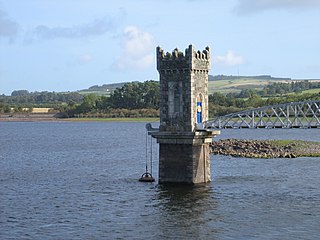
Vartry Reservoir is a reservoir at Roundwood in County Wicklow, Ireland. The water is piped from Vartry to a large open service reservoir in Stillorgan in the southern suburbs of Dublin. The reservoir is operated by Irish Water.

<span class="mw-page-title-main">River Vartry</span> River in County Wicklow, Ireland

The River Vartry is a river in County Wicklow, Ireland, and an important water source for the city of Dublin.

<span class="mw-page-title-main">Grand Canal Dock</span> Docklands area east of Dublin city centre, Ireland

Grand Canal Dock is a Southside area near the city centre of Dublin, Ireland. It is located on the border of eastern Dublin 2 and the westernmost part of Ringsend in Dublin 4, surrounding the Grand Canal Docks, an enclosed harbour where the Grand Canal comes to the River Liffey. The area has undergone significant redevelopment since 2000, as part of the Dublin Docklands area redevelopment project.

<span class="mw-page-title-main">Poulaphouca Reservoir</span> Dam in County Wicklow

Poulaphouca Reservoir, officially Pollaphuca, is an active reservoir and area of wild bird conservation in west County Wicklow, Ireland named after the Poulaphouca waterfall on its south-western end where the water exits the lake. The lake is also commonly known as the Blessington Lakes, even though there is just one.

<span class="mw-page-title-main">Britain Quay</span> Street and quay in Dublin, Ireland

Britain Quay is a street and quay in Dublin on the south bank of the River Liffey between Sir John Rogerson's Quay and the confluence of the River Liffey, River Dodder and Grand Canal.

<span class="mw-page-title-main">Neher water system</span>

Neher water system provided clean water for the people of Aurangabad and its suburbs. It was created by Malik Ambar who founded the town under the name Khadki and was later expanded by Aurangzeb to facilitate the military activity that became prevalent under Mughal rule during the 17th century.

The Back of the Pipes was the name of a lane and pipe route in Dublin 8, Ireland, located between Dolphin's Barn and James's Walk. The lane replaced a Grand Canal branch which ultimately fed the Dublin city basin and the Grand Canal Harbour.

<span class="mw-page-title-main">Blessington Street Basin</span> Former reservoir, now part of a park, central Dublin, Ireland

Blessington Street Basin is a former drinking water reservoir in northern central Dublin which operated from 1810 until the 1970s, serving the north city. It became the central feature of a public park in 1891, and this park was renewed and reopened in 1994.

Leixlip is a civil parish and a townland located in the north-eastern corner of County Kildare, Ireland. The civil parish is mainly in the ancient barony of Salt North with a small part in the neighbouring barony of Newcastle. It is centred on the town of Leixlip. In geology, the parish rests on a substratum of limestone, and contains chalybeate springs. It lies at the confluence of the River Liffey and the Rye Water.

<span class="mw-page-title-main">Ormond Square, Dublin</span> Square in Dublin, Ireland

Ormond Square is a square on the northside of Dublin city.

References

  1. "» A Snippet of Dublin History (Part 8) – Basin Street Harbour". www.frg.ie. Retrieved 30 May 2024.
  2. COFFEY, Andrew (1829). "A View of the Past and Present State of the Works for Supplying Dublin with Water". A.B. King, His Majesty's Stationer. Retrieved 29 May 2024.
  3. "Minutes of Proceedings of the Institution of Civil Engineers". Institution of Civil Engineers. 1874. Retrieved 29 May 2024.
  4. Cameron, Charles A. (1868). "Reports on the Vartry Water". Joseph Dollard, Printer. Retrieved 30 May 2024.
  5. "Pamphlets: Sewage, Water Supply, Sanitary Science". 1874. Retrieved 30 May 2024.
  6. Weale, John (1847). "Quarterly Papers on Engineering" . Retrieved 30 May 2024.
  7. MAPOTHER, Edward Dillon (1864). "Lectures on Public Health, Delivered at the Royal College of Surgeons, Etc" . Retrieved 30 May 2024.
  8. "Gabriel Stokes". www.dia.ie. Retrieved 30 May 2024.
  9. "Another description of the Dublin City Bason". Irish waterways history. 4 October 2012. Retrieved 4 June 2024.
  10. McAuley, Eimer (16 March 2023). "Workers unearth old Dublin city basin that was a social hotspot in the 1830s". TheJournal.ie. Retrieved 30 May 2024.
  11. Delany, D. Ruth (1973). "The Grand Canal of Ireland". David & Charles. Retrieved 11 June 2024.
  12. "1788 - Proposal to link Grand Canal with Liffey, Dublin". Architecture @ Archiseek.com. 22 July 2014. Retrieved 11 June 2024.
  13. "Bond Harbour and buildings". www.dia.ie. Retrieved 11 June 2024.
  14. "Malt House". www.dia.ie. Retrieved 11 June 2024.
  15. "Guinness Brewery , Robert Street, Market Street South, Dublin 8, DUBLIN". Buildings of Ireland. Retrieved 11 June 2024.