
D'Entrecasteaux National Park is a national park in Western Australia, 315 kilometres (196 mi) south of Perth. The park is named after the French Admiral Bruni D'Entrecasteaux who was the first European to sight the area and name Point D'Entrecasteaux in 1792. The park received 168,497 visitors through 2008–2009.
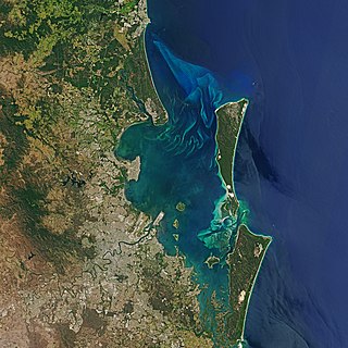
Moreton Bay is a bay located on the eastern coast of Australia 14 kilometres (8.7 mi) from central Brisbane, Queensland. It is one of Queensland's most important coastal resources. The waters of Moreton Bay are a popular destination for recreational anglers and are used by commercial operators who provide seafood to market.

The Spencer Gulf is the westernmost and larger of two large inlets on the southern coast of Australia, in the state of South Australia, facing the Great Australian Bight. It spans from the Cape Catastrophe and Eyre Peninsula in the west to Cape Spencer and Yorke Peninsula in the east.

Macquarie Harbour is a shallow fjord located in the West Coast region of Tasmania, Australia. It is approximately 315 sq.km, and has an average depth of 15m, with deeper places up to 50m. It is navigable by shallow-draft vessels. The main channel is kept clear by the presence of a rock wall on the outside of the channel's curve. This man-made wall prevents erosion and keeps the channel deep and narrow, rather than allowing the channel to become wide and shallow. A reported Aboriginal name for the harbour is Parralaongatek.

Western Port, commonly but unofficially known as Western Port Bay, is a large tidal bay in southern Victoria, Australia, opening into Bass Strait. It is the second largest bay in the state. Geographically, it is dominated by two large islands; French Island and Phillip Island. At the time it was named, its position was west of other known ports and bays, but Western Port has become something of a misnomer as it lies just to the east of the larger Port Phillip and the city of Melbourne. It is visited by Australian fur seals, whales and dolphins, as well as many migratory waders and seabirds. It is listed under the Ramsar Convention as a wetland of international significance.
Sandy Island may refer to:

King George Sound is the name of a sound on the south coast of Western Australia. Originally named King George the Third's Sound, it was referred to as King George's Sound from 1805. The name "King George Sound" gradually came into use from about 1934, prompted by new Admiralty charts supporting the intention to eliminate the possessive 's' from geographical names.
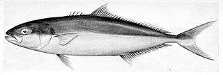
The yellowtail amberjack, yellowtail kingfish or great amberjack is a large fish found in the Southern Ocean. Although previously thought to be found in all oceans and seas, recent genetic analysis restricts S. lalandi proper to the Southern Hemisphere waters. However, they are found in northern hemisphere waters during certain times of the year. The fish was given its name by Monsieur de Lalande, a naturalist who first informed Valenciennes of the existence of this species. No one is sure why he used the word Seriola to name the fish, but the second word lalandi was derived from his surname Lalande.

Random Island is located off Canada's Atlantic coast. Part of the Province of Newfoundland and Labrador, it is located on the east coast of Newfoundland and partially surrounded by the Bonavista Peninsula on the north and within the confines of Trinity Bay. The island is approximately 35 km (22 mi) long, its width varies from 15 km (9.3 mi) on the eastern end, to 6 km (3.7 mi) in the middle, to 17 km (11 mi) on the western end, with a total area of around 310 km2 (120 sq mi). According to the 2016 census, the population of the island is 1,232.

Cowell is a coastal town on Franklin Harbor on the eastern side of the Eyre Peninsula, in South Australia on the Lincoln Highway 111 km south of the major town of Whyalla. It is 493 km by road from Adelaide.

Pedra Branca is a rock islet or small island, located in the Southern Ocean, off the southern coast of Tasmania, Australia. The island is situated approximately 26 kilometres (16 mi) south southeast of South East Cape and is contained within the Southwest National Park, part of the Tasmanian Wilderness World Heritage Site. An erosional remnant of the Tasmanian mainland, the island is approximately 270 metres (890 ft) long, 100 metres (330 ft) wide, with an elevation of 60 metres (200 ft) above sea level. The island is estimated to have separated from the Tasmanian mainland at least 15,000 years ago.

The Breaksea Islands Group is a group of six islands, located in the Southern Ocean, off the south western coast of Tasmania, Australia.

Northcliffe is a town located in the lower South West region of Western Australia, about 28 kilometres (17 mi) south of the town of Pemberton. It is part of the Shire of Manjimup. At the 2006 census, Northcliffe had a population of 412. Currently, Northcliffe serves a population of around 770 people within the town and surrounding areas. Approximately 31% of the population have post-secondary qualifications.

Currie is a rural residential locality in the local government area (LGA) of King Island in the North-west and west LGA region of Tasmania. The 2016 census provides a population of 768 for the state suburb of Currie. It is the largest township on, and is the administrative centre of, King Island, at the western entrance to Bass Strait.
The south coast of Western Australia comprises the Western Australian coastline from Cape Leeuwin to Eucla. This is a distance of approximately 1,600 kilometres (1,000 mi), fronting the Great Australian Bight and the Southern Ocean.

Sandy Island is a 20 ha island lying about 5 km (3.1 mi) off the coast of Windy Harbour in south-west Western Australia, and near Point D'Entrecasteaux. It is part of D'Entrecasteaux National Park and is an important breeding site for seabirds.
Windy Harbour is a holiday settlement surrounded by D’Entrecasteaux National Park. Located 27km south of Northcliffe, on the south coast of Western Australia east of Augusta and west of Nornalup. It lies just east of Point D'Entrecasteaux.

Mourilyan Harbour is a coastal locality and harbour within the Cassowary Coast Region, Queensland, Australia. In the 2016 census, Mourilyan Harbour had a population of 156 people.
Quagering Island is an island off the south coast of Western Australia, located near Windy Harbour, and along with Sandy Island makes the Quagering Nature Reserve.

Bynoe Harbour is a locality in the Northern Territory of Australia located about 41 kilometres (25 mi) south-west of the territory capital of Darwin.
