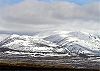
The Cairngorms are a mountain range in the eastern Highlands of Scotland closely associated with the mountain Cairn Gorm. The Cairngorms became part of Scotland's second national park on 1 September 2003. Although the Cairngorms give their name to, and are at the heart of, the Cairngorms National Park, they only form one part of the national park, alongside other hill ranges such as the Angus Glens and the Monadhliath, and lower areas like Strathspey.

Ben Macdui is the second-highest mountain in Scotland and all of the British Isles, after Ben Nevis, and the highest of the Cairngorm Mountains. The summit is 1,309 metres (4,295 ft) above sea level and it is classed as a Munro. Ben Macdui is situated on the southwestern edge of the Cairngorm plateau, overlooking the Lairig Ghru pass to the west, and Loch Etchachan to the east. It lies on the boundary between the historic counties of Aberdeenshire and Banffshire.
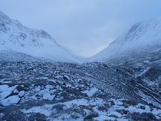
The Lairig Ghru is one of the mountain passes through the Cairngorms of Scotland. The route and mountain pass partially lies on the Mar Lodge Estate.

Braeriach or Brae Riach is the third-highest mountain in Scotland and all of the British Isles, after Ben Nevis and Ben Macdui, rising 1,296 metres (4,252 ft) above sea level. It is in the Scottish Highlands and is the highest point in the western massif of the Cairngorms, separated from the central section by the Lairig Ghru pass. The summit is a crescent-shaped plateau, overlooking several corries.
Carn Eighe is a mountain in the Northwest Highlands of Scotland. Rising to 1,183 metres (3,881 ft) above sea level, it is the highest mountain in Scotland north of the Great Glen, the twelfth-highest in the British Isles, and, in terms of relative height, it is the second-tallest mountain in the British Isles after Ben Nevis. Carn Eighe lies between Glen Affric and Loch Mullardoch, and is at the heart of a massif along with its twin peak, the 1,181-metre (3,875 ft) Mam Sodhail.

Cairn Toul is the 4th-highest mountain in Scotland and all of the British Isles, after Ben Nevis, Ben Macdui and Braeriach. The summit is 1,291 metres above sea level. It is in the western massif of the Cairngorms, linked by a bealach at about 1125 m to Braeriach. The mountain towers above the Lairig Ghru pass.

Sgòr an Lochain Uaine is one of the Cairngorms mountains in the Scottish Highlands. Rising to 1,258 metres (4,127 ft), by some counts it is the fifth-highest mountain in Scotland. It is in the western massif of the Cairngorms, standing between Braeriach and Cairn Toul, overlooking An Garbh Choire and the Lairig Ghru pass. It was promoted to Munro status by the Scottish Mountaineering Club's 1997 revision of the tables.

Bynack More is a Scottish Mountain that is situated in the Cairngorms range, 16 kilometres east-south-east of the town of Aviemore in the Highland region.

Mam Sodhail, or Màm Sabhail in Gaelic, sometimes anglicised "Mam Soul", is a mountain with a height of 1,181 metres (3,875 ft) in the Northwest Highlands of Scotland. Classed as a Munro, it is beside Carn Eige in the secluded country on the northern side of Glen Affric, some 30 kilometres east of Kyle of Lochalsh.

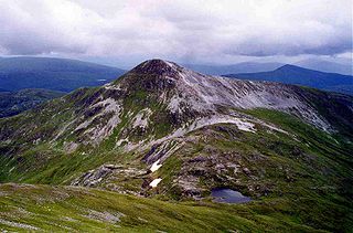
Beinn a' Chaorainn is a Scottish mountain in the heart of the Cairngorms range. It is quite a remote hill, being located roughly 19 kilometres south east of Aviemore and 14 kilometres north west of Braemar. The mountain stands on the border of the Moray and Aberdeenshire council areas. The hill's name used to be spelt as Beinn a' Chaoruinn, but the spelling of the word caorunn was altered to caorann by the Gaelic Orthographic Convention's attempts to standardise spelling.

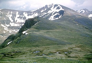
Càrn a' Mhàim is a Scottish mountain situated in the inner part of the Cairngorms range, some 15 kilometres west of Braemar in the county of Aberdeenshire.
Stob Bàn is a mountain situated in the Lochaber region of Highland, Scotland, 16 kilometres east of Fort William. It reaches a height of 977 metres (3205 feet) and lies in a group of hills known as the Grey Corries which includes three other Munros and nine Munro "Tops" along an eight kilometre ridge. The mountain's name translate as “White Peak”, while other sources give the translation as Light Coloured Peak with the hill being covered in light coloured schist scree, in contrast to the rest of the Grey Corries which are made up of grey quartzite scree. The mountain is a prominent conical shape, isolated from the rest of the group and distant from any main roads. It should not be confused with another Munro named Stob Bàn situated in the Mamores.

Corrour Bothy is a simple stone building on Mar Lodge Estate, Aberdeenshire, Scotland.
Glen Lui from Gleann Laoigh – calves' glen – Gordon (1925) is one of the major glens on the Mar Lodge Estate, in Aberdeenshire, Scotland.

Càrn Mairg is a mountain in the Breadalbane region of the Scottish Highlands, with a height of 1,042 metres (3,419 ft). It stands in a group of four Munro mountains known as the 'Càrn Mairg group', on the north side of Glen Lyon, Perthshire.
Mar Lodge Estate is the largest remnant of the ancient Earldom of Mar in Aberdeenshire, Scotland and is now owned by the National Trust for Scotland.
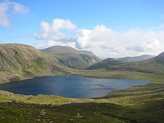
Loch Etchachan is a remote freshwater loch set deep within the central Cairngorms plateau, in the Cairngorms National Park, located in the eastern Highlands of Scotland. It is the highest waterbody of its size in the UK, the surface being 927 metres (3,041 ft) above sea level. However, the highest named bodies of water in the UK are Loch Coire an Lochain, which lies 6km to the west of Loch Etchachan on the opposite side of the Lairig Ghru, and Lochan Buidhe, which lies between Cairn Lochan and Ben Macdui.
The Cairngorm Plateau disaster, also known as the Feith Buidhe disaster, occurred in November 1971 when six fifteen-year-old Edinburgh school students and their two leaders were on a two-day navigational expedition in a remote area of the Cairngorms in the Scottish Highlands.

The Lairig an Laoigh is a mountain pass through the Highlands of Scotland. In speech and sometimes in writing the name is reduced to "Lairig Laoigh". It is of glacial origin, dissecting the Cairngorm plateau, and it runs roughly north–south from Speyside to Deeside at one time being used as a drove road. Between the public road in the Abernethy Forest and the one at Linn of Dee the trekking distance is 31 kilometres (19 mi).

Beinn Mheadhoin or Beinn Meadhain is a mountain in the Highlands of Scotland. It is a Munro with a height of 1,182 metres (3,878 ft) and by some counts it is the twelfth-highest mountain of Great Britain. It lies in the very heart of the Cairngorm mountains, and is one of the most remote in the region. Beinn Mheadoin is surrounded by deep glens and mountain lakes, including Loch A'an, Loch Etchachan and the Dubh Lochan.