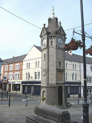
Llangefni is the county town of Anglesey in Wales. At the 2011 census, Llangefni's population was 5,116, making it the second-largest town in the county and the largest on the island. The community includes the village of Rhosmeirch.

The River Teifi in Wales forms the boundary for most of its length between the counties of Ceredigion and Carmarthenshire, and for the final 3 miles (4.8 km) of its total length of 76 miles (122 km), the boundary between Ceredigion and Pembrokeshire. Its estuary is northwest of Cardigan, known in Welsh as Aberteifi, meaning 'mouth of the Teifi'. Teifi has formerly been anglicised as "Tivy".
Afon Ogwen is a river in north-west Wales draining from some of the greatest peaks in Snowdonia before discharging to the sea on the eastern side of Bangor, Gwynedd.

Abergwyngregyn is a village and community of historical note in Gwynedd, a county and principal area in Wales. Under its historic name of Aber Garth Celyn it was the seat of Llywelyn ap Gruffudd. It lies in the historic county of Caernarfonshire.

Valley is a village, community, and former electoral ward near Holyhead on the west coast of Anglesey, North Wales. The population during the 2001 census was 2,413, decreasing to 2,361 at the 2011 census.
Newborough Warren near the village of Newborough (Niwbwrch) in Anglesey, Wales, is a large dune and beach system of 2,269 hectares, approximately half of which is a conifer plantation. The whole area is designated as a Site of Special Scientific Interest and all of the site except the forestry is a national nature reserve.

The Isle of Anglesey County Council is the local authority for the Isle of Anglesey, a principal area with county status in Wales. Since 2022 the council has 35 councillors who represent 11 multi-member electoral wards.
Rhosmeirch is a small village in Anglesey, Wales. It is in the community of Llangefni.
The Anglesey Central Railway was a 17.5-mile (28.2 km) standard-gauge railway in Anglesey, Wales, connecting the port of Amlwch and the county town of Llangefni with the North Wales Coast Line at Gaerwen. Built as an independent railway, the railway opened in portions from 1864 to 1867. Due to financial troubles the railway was sold to the London and North Western Railway in 1876, which invested significantly in the infrastructure. Operation continued under various companies during the 20th century, but passenger services were withdrawn in 1964 as part of the Beeching Axe. Industrial freight services continued until 1993. The railway's tracks remain and local groups have demonstrated an interest in restoring services as a heritage railway.
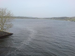
Llyn Cefni is a small reservoir in the centre of Anglesey, Wales which is managed by Welsh Water and Hamdden Ltd, while the fishery is managed by the Cefni Angling Association. The reservoir is located just 1 kilometre (0.6 mi) northwest of the island's county town of Llangefni.
The Deeside Tramway was a gravity and horse-worked, 2 ft 6 in narrow gauge industrial railway connecting the slate workings on the Dee valley with the main road at Glyndyfrdwy and later the Great Western Railway's Ruabon-Dolgellau railway. It was one of the last tramways in regular use to use wooden rails covered in iron sheaths.

Llangefni railway station was situated on the Anglesey Central Railway line from Gaerwen to Amlwch.
Llan and its variants are a common element of Celtic placenames in the British Isles and Brittany, especially of Welsh toponymy. In Welsh the name of a local saint or a geomorphological description follows the Llan morpheme to form a single word: for example Llanfair is the parish or settlement around the church of St. Mair. Goidelic toponyms end in -lann.

Anglesey is an island off the north-west coast of Wales. It forms the bulk of the county known as the Isle of Anglesey, which also includes Holy Island and some islets and skerries. The county borders Gwynedd across the Menai Strait to the southeast, and is otherwise surrounded by the Irish Sea. Holyhead is the largest town, and the administrative centre is Llangefni. The county is part of the preserved county of Gwynedd. Anglesey is the northernmost county in Wales.

Valley Wetlands, formerly Valley Lakes, is a nature reserve in Anglesey, Wales belonging to the Royal Society for the Protection of Birds. It is an area of lakes and reedbeds to the south-east of Valley in Llanfair-yn-Neubwll community, adjacent to RAF Valley airfield. The western section of the reserve includes Llyn Penrhyn, Llyn Treflesg and part of Llyn Dinam. The eastern part includes Llyn Traffwll and wetlands along the Afon Crigyll. Much of the reserve is included within two Sites of Special Scientific Interest.

The Anglesey Coalfield is a minor British coalfield. Although it is situated in north-west Wales, this isolated coalfield on Anglesey is not usually considered to form a part of the North Wales Coalfield which lies in Flintshire and Denbighshire in north-east Wales although both measures were formed during the Carboniferous period. Stretching from Nant and Hirdrefaig in the Pentre Berw area along Cors Ddyga and under the sea at Malltraeth village which was called 'yr Iard' or 'Iard Malltraeth'. On the western side of the Afon Cefni lies Cors Malltraeth. It was named after Cwmwd Malltraeth (Commote) which was the old Welsh way of dividing the Isle of Mona by the Welsh Princes and the Church. Both coalfields measure around 9 miles long.

Dwygyfylchi is a village in Conwy County Borough, Wales. It is part of the community of Penmaenmawr which has a population of 4,353. The electoral ward of Capelulo which includes Dwygyfylchi had a population of 1,485 in 2011. It forms part of the historic county of Caernarfonshire.

Malltraeth Marsh is a large marsh area in Anglesey, North Wales, north-east of Malltraeth village, along the flatlands of Trefdraeth, Bodorgan, Llangristiolus and south of Cefn Cwmwd, Rhostrehwfa. It was reclaimed from estuarine marshes after the construction of the Malltraeth Cob (dyke), a 1 mile (1.6 km) long embankment, and the subsequent canalisation in 1824 of the Afon Cefni.

Nant-y-Ffrith refers to a stream and the wooded valley through which it flows on the border between Flintshire and Wrexham County Borough in Wales. The stream begins in moorland to the east of Llandegla. It passes Bwlchgwyn village before entering a rather steep-sided, rocky valley. It passes under the viaduct of a disused railway line before joining the River Cegidog at Ffrith.

Llyn Traffwll is a 91 acre natural lake located, in Anglesey, Wales. Located midway between the villages of Rhosneigr and Valley it lies less than a kilometre south of the A55 North Wales Expressway. It is one of the largest natural lake on the island with Llyn Alaw and Llyn Cefni both being reservoirs. Along with the surrounding smaller lakes it is a Site of Special Scientific Interest and is adjacent to the Valley Wetlands RSPB site. Formerly the lake was used to supply water to Holyhead by the Holyhead Water Company, and to aid water management a small dam was built which still exists.
