
The Red Line is a rapid transit line operated by the Massachusetts Bay Transportation Authority (MBTA). It runs roughly northwest-to-southeast across Cambridge and Davis Square in Somerville – from Alewife in North Cambridge to Kendall/MIT in Kendall Square – with a connection to commuter rail at Porter. It then crosses over the Longfellow Bridge into downtown Boston, where it connects with the Green Line at Park Street, the Orange Line at Downtown Crossing, the Silver Line at South Station, as well as Amtrak and commuter rail at the South Station surface terminal before passing through South Boston and Dorchester. South of JFK/UMass in Dorchester, it splits into two branches terminating at Braintree and Ashmont stations; transfers to commuter rail are again possible at JFK/UMass, Quincy Center, and Braintree. From Ashmont, passengers may continue to Mattapan via the Ashmont–Mattapan High Speed Line, a 2.6-mile (4.2 km) light rail line.

Davis Square is a major intersection in the northwestern section of Somerville, Massachusetts where several streets meet: Holland Street, Dover Street, Day Street, Elm Street, Highland Avenue, and College Avenue. The name is often used to refer to the West Somerville neighborhood surrounding the square as well.
Porter Square is a neighborhood in Cambridge and Somerville, Massachusetts in the USA, located around the intersection of Massachusetts Avenue and Somerville Avenue, between Harvard and Davis Squares. The Porter Square station serves both the MBTA Red Line and the Commuter Rail Fitchburg Line. A major part of the Lesley University campus is located within the Porter Square area.

Alewife is an intermodal transit station in Cambridge, Massachusetts that is the northern terminus of the MBTA's Red Line subway system. It is also a hub for several MBTA Bus lines. Alewife station is located in the North Cambridge neighborhood, adjacent to the interchange between Alewife Brook Parkway and the Massachusetts Route 2 freeway, with ramps providing direct access to and from the expressway portion of Route 2. Its facilities include a multi-level parking garage with 2,733 spaces, three secured bicycle cages, a busway with an enclosed waiting room for bus passengers, and connections to the Minuteman Bikeway, Cambridge Linear Park, and the Fitchburg Cutoff Path.

Porter is a Massachusetts Bay Transportation Authority (MBTA) transit station in Cambridge, Massachusetts. It serves the Red Line rapid transit line, the MBTA Commuter Rail Fitchburg Line, and several MBTA Bus lines. Located at Porter Square at the intersection of Massachusetts and Somerville Avenues, the station provides rapid transit access to northern Cambridge and the western portions of Somerville. Porter is 14 minutes from Park Street on the Red Line, and about 10 minutes from North Station on commuter rail trains. Several local MBTA Bus routes also stop at the station.
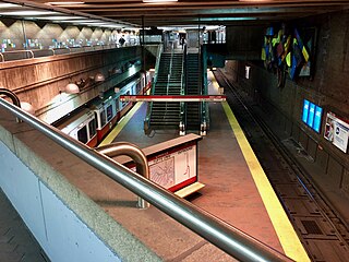
Davis is an MBTA transit station in Somerville, Massachusetts. It serves the Red Line. It is located at Davis Square, at the intersection of Holland Street, Elm Street, and College Avenue. By consequence of geography and system layout, Davis is one of only two rapid transit stations in Somerville, the other being Assembly on the Orange Line. It is bordered on both sides by stations that lie in Cambridge: Alewife and Porter.

The Minuteman Bikeway is a 10-mile (16-kilometre) paved multi-use rail trail located in the Greater Boston area of Massachusetts. It runs from Bedford to Alewife station, at the northern end of the Red Line in Cambridge, passing through the towns of Lexington and Arlington along the way. Also along the route are several notable regional sites, including Alewife Brook Reservation, Spy Pond, "Arlington’s Great Meadows", the Battle Green in Lexington, and Hanscom Air Force Base.
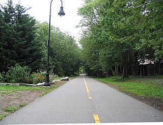
The Somerville Community Path is a paved mixed-use path in Somerville, Massachusetts, running 0.8 mile (1.3 km) from the Alewife Linear Park border to Lowell Street via Davis Square.

Massachusetts Avenue is a major thoroughfare in Boston, Massachusetts, and several cities and towns northwest of Boston. According to Boston magazine, "Its 16 miles of blacktop run from gritty industrial zones to verdant suburbia, passing gentrified brownstones, college campuses and bustling commercial strips."
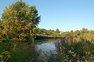
Alewife Brook Reservation is a Massachusetts state park and urban wild located in Cambridge, Arlington, and Somerville. The park is managed by the state Department of Conservation and Recreation and was established in 1900. It is named for Alewife Brook, which was also historically known as Menotomy River, a tributary of the Mystic River.

The Fitchburg Cutoff Path is a short multi-use rail trail located in suburban Boston, Massachusetts.

The Lexington and West Cambridge Railroad was a railroad company chartered in 1845 and opened in 1846 that operated in eastern Massachusetts. It and its successors provided passenger service until 1977 and freight service until 1980 or early 1981.
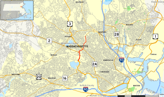
Alewife Brook Parkway is a short parkway in Cambridge and Somerville, Massachusetts. It is listed on the National Register of Historic Places. It begins at Fresh Pond in Cambridge, and heads north on the east bank of Alewife Brook, crossing into West Somerville and ending at the Mystic River on the Medford town line, where it becomes Mystic Valley Parkway. The entire length of Alewife Brook Parkway is designated as part of Massachusetts Route 16 (Route 16), while the southernmost sections are also designated as part of Route 2 and U.S. Route 3 (US 3). It is managed by the Department of Conservation and Recreation with the Massachusetts Department of Transportation responsible for bridge maintenance.
Carlos Dorrien is an American sculptor of Mexican descent. He studied at Montserrat School of Visual Art and at Massachusetts College of Art. He later joined the faculty of Wellesley College, where he has taught for many years.
Cambridge Highlands also known as "Area 12", is a neighborhood of Cambridge, Massachusetts bounded by the railroad tracks on the north and east, the Belmont town line on the west, and Fresh Pond on the south. In 2005 it had a population of 673 residents living in 281 households, and the average household income was $56,500.
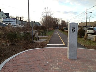
The Watertown Branch Railroad was a branch loop of the Fitchburg Railroad that was meant to serve the town of Watertown and the City of Waltham, Middlesex County, Massachusetts, as an independent short line railroad; it also serviced the Watertown Arsenal. The line has been formally abandoned and portions are being converted into a rail trail, the Watertown-Cambridge Greenway. A section from School Street to Arlington Street in Watertown has been completed. A small portion in Waltham has been converted into a park called Chemistry Station Park after the railroad station once located there. Construction of an extension to Fresh Pond Reservation in Cambridge began in the summer of 2018 and is expected to be completed in June 2020.

Arts on the Line was a program devised to bring art into the Massachusetts Bay Transportation Authority (MBTA)'s subway stations in the late 1970s and early 1980s. Arts on the Line was the first program of its kind in the United States and became the model for similar drives for art across the country. The first twenty artworks were completed in 1985 with a total cost of US$695,000, or one half of one percent of the total construction cost of the Red Line Northwest Extension, of which they were a part.

Gift of the Wind is a large-scale public kinetic sculpture, by Susumu Shingu, located in Porter Square, Cambridge, Massachusetts at the Porter, Massachusetts Bay Transportation Authority subway and commuter rail station. The art work consists of a tall white pole with three red "wings" attached to the top that are "designed to shift in response to the movement of the wind, not only turning clockwise and counterclockwise, but tumbling over and over in various sequences." It is considered by some to be "Cambridge's most visible landmark".>

Untitled is a public art installation by Richard Fleischner located in a courtyard adjacent to the Alewife station on the MBTA Red Line in northwest Cambridge, Massachusetts. The artwork - an environmental piece consisting of granite block designs among a landscape - cost $40,000 to create in 1985.
The Massachusetts Bay Transportation Authority operates subway, bus, commuter rail, and ferry service in the Greater Boston region. Boston has some of the highest rates of non-motorized commuting in the United States, including high bicycle usage. The MBTA offers certain provisions for riders wishing to make part of their trips by bicycle. The agency allows bicycles to be carried on all fixed-route services except the Green Line and the Ashmont-Mattapan High Speed Line light rail lines, although they are restricted on the commuter rail and heavy rail subway services at peak hours. Bicycle storage areas are offered at many stations, with "Pedal and Park" locking bicycle cages at certain high-usage stations.


