The Great Devonian Controversy began in 1834 when Roderick Murchison disagreed with Henry De la Beche as to the dating of certain petrified plants found in coals in the Greywacke stratum in North Devon, England. De La Beche was claiming that since Carboniferous fossils were found deep in the Greywacke stratum, which itself was older than the Carboniferous period, this method of dating rocks was not valid. Murchison, in contrast, claimed that De La Beche had not placed the fossils correctly, as they were occurring quite near the top of the stratum as opposed to deep within it. De La Beche soon agreed with Murchison's argument as to the placing of fossils but maintained that since a layer of Old Red Sandstone, present in other formations, was missing between the layer of older rock and this new formation, there was still insufficient evidence to suggest the formation was not part of the older Silurian strata.
There followed much debate and some extensive investigations which ranged as far as Russia, where in 1840 Murchison discovered a layer similar to the one found in Devon placed between well-defined Silurian and Carboniferous deposits. This discovery put an end to the controversy and led to the definition of a new period called Devonian.
Further reading
Rudwick, Martin J. S.The Great Devonian Controversy: The Shaping of Scientific Knowledge among Gentlemanly Specialists. Chicago, University of Chicago Press. 1985.
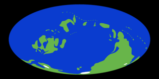
The Devonian is a geologic period and system of the Paleozoic era during the Phanerozoic eon, spanning 60.3 million years from the end of the preceding Silurian period at 419.2 million years ago (Ma), to the beginning of the succeeding Carboniferous period at 358.9 Ma. It is named after Devon, South West England, where rocks from this period were first studied.
The PaleozoicEra is the first of three geological eras of the Phanerozoic Eon. Beginning 538.8 million years ago (Ma), it succeeds the Neoproterozoic and ends 251.9 Ma at the start of the Mesozoic Era. The Paleozoic is subdivided into six geologic periods :
The Silurian is a geologic period and system spanning 24.6 million years from the end of the Ordovician Period, at 443.8 million years ago (Mya), to the beginning of the Devonian Period, 419.2 Mya. The Silurian is the shortest period of the Paleozoic Era. As with other geologic periods, the rock beds that define the period's start and end are well identified, but the exact dates are uncertain by a few million years. The base of the Silurian is set at a series of major Ordovician–Silurian extinction events when up to 60% of marine genera were wiped out.
Old Red Sandstone, abbreviated ORS, is an assemblage of rocks in the North Atlantic region largely of Devonian age. It extends in the east across Great Britain, Ireland and Norway, and in the west along the eastern seaboard of North America. It also extends northwards into Greenland and Svalbard. These areas were a part of the paleocontinent of Euramerica (Laurussia). In Britain it is a lithostratigraphic unit to which stratigraphers accord supergroup status and which is of considerable importance to early paleontology. The presence of Old in the name is to distinguish the sequence from the younger New Red Sandstone which also occurs widely throughout Britain.
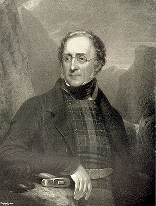
Sir Roderick Impey Murchison, 1st Baronet was a Scottish geologist who served as director-general of the British Geological Survey from 1855 until his death in 1871. He is noted for investigating and describing the Silurian, Devonian and Permian systems.
Sir Henry Thomas De la Beche KCB, FRS was an English geologist and palaeontologist, the first director of the Geological Survey of Great Britain, who helped pioneer early geological survey methods. He was the first President of the Palaeontographical Society.
An unconformity is a buried erosional or non-depositional surface separating two rock masses or strata of different ages, indicating that sediment deposition was not continuous. In general, the older layer was exposed to erosion for an interval of time before deposition of the younger layer, but the term is used to describe any break in the sedimentary geologic record. The significance of angular unconformity was shown by James Hutton, who found examples of Hutton's Unconformity at Jedburgh in 1787 and at Siccar Point in Berwickshire in 1788, both in Scotland.
William Lonsdale, English geologist and palaeontologist, won the Wollaston medal in 1846 for his research on the various kinds of fossil corals.
Robert Alfred Cloyne Godwin-Austen FRS was an English geologist.
Greywacke or graywacke is a variety of sandstone generally characterized by its hardness, dark color, and poorly sorted angular grains of quartz, feldspar, and small rock fragments or sand-size lithic fragments set in a compact, clay-fine matrix. It is a texturally immature sedimentary rock generally found in Paleozoic strata. The larger grains can be sand- to gravel-sized, and matrix materials generally constitute more than 15% of the rock by volume.
The geology of Scotland is unusually varied for a country of its size, with a large number of different geological features. There are three main geographical sub-divisions: the Highlands and Islands is a diverse area which lies to the north and west of the Highland Boundary Fault; the Central Lowlands is a rift valley mainly comprising Palaeozoic formations; and the Southern Uplands, which lie south of the Southern Uplands Fault, are largely composed of Silurian deposits.
The Ludlow Group are geologic formations deposited during the Ludlow epoch of the Silurian period in the British Isles, in areas of England, Ireland, Scotland, and Wales.
South Wales is an area with many features of outstanding interest to geologists, who have for long used the area for University field trips.
Adam Sedgwick was a British geologist and Anglican priest, one of the founders of modern geology. He proposed the Cambrian and Devonian period of the geological timescale. Based on work which he did on Welsh rock strata, he proposed the Cambrian period in 1835, in a joint publication in which Roderick Murchison also proposed the Silurian period. Later in 1840, to resolve what later became known as the Great Devonian Controversy about rocks near the boundary between the Silurian and Carboniferous periods, he and Murchison proposed the Devonian period.
The geology of Wales is complex and varied; its study has been of considerable historical significance in the development of geology as a science. All geological periods from the Cryogenian to the Jurassic are represented at outcrop, whilst younger sedimentary rocks occur beneath the seas immediately off the Welsh coast. The effects of two mountain-building episodes have left their mark in the faulting and folding of much of the Palaeozoic rock sequence. Superficial deposits and landforms created during the present Quaternary period by water and ice are also plentiful and contribute to a remarkably diverse landscape of mountains, hills and coastal plains.
This article attempts to place key plant innovations in a geological context. It concerns itself only with novel adaptations and events that had a major ecological significance, not those that are of solely anthropological interest. The timeline displays a graphical representation of the adaptations; the text attempts to explain the nature and robustness of the evidence.
Hutton's Unconformity is a name given to various notable geological sites in Scotland identified by the 18th-century Scottish geologist James Hutton as places where the junction between two types of rock formations can be seen. This geological phenomenon marks the location where rock formations created at different times and by different processes adjoin. For Hutton, such an unconformity provided evidence for his Plutonist theories of uniformitarianism and the age of Earth.
The Highlands controversy was a scientific controversy which started between British geologists in the middle of the nineteenth century concerning the nature of the rock strata in the Northwest Highlands of Scotland. The disagreement stemmed from the apparent ages of the strata, particularly the, now confirmed, existence of older rock above younger rock as well as duplicated and inverted strata, which could not be satisfactorily explained by contemporary geology. This rock formation and surrounding controversy were the impetus for Albert Heim's theory of Thrust faulting, which, in conjunction with anticlines and imbrication, are now commonly accepted as the primary geologic mechanisms that created the Northwest Highlands rock strata.
The geology of Ohio formed beginning more than one billion years ago in the Proterozoic eon of the Precambrian. The igneous and metamorphic crystalline basement rock is poorly understood except through deep boreholes and does not outcrop at the surface. The basement rock is divided between the Grenville Province and Superior Province. When the Grenville Province crust collided with Proto-North America, it launched the Grenville orogeny, a major mountain building event. The Grenville mountains eroded, filling in rift basins and Ohio was flooded and periodically exposed as dry land throughout the Paleozoic. In addition to marine carbonates such as limestone and dolomite, large deposits of shale and sandstone formed as subsequent mountain building events such as the Taconic orogeny and Acadian orogeny led to additional sediment deposition. Ohio transitioned to dryland conditions in the Pennsylvanian, forming large coal swamps and the region has been dryland ever since. Until the Pleistocene glaciations erased these features, the landscape was cut with deep stream valleys, which scoured away hundreds of meters of rock leaving little trace of geologic history in the Mesozoic and Cenozoic.
The geology of Afghanistan includes nearly one billion year old rocks from the Precambrian. The region experienced widespread marine transgressions and deposition during the Paleozoic and Mesozoic, that continued into the Cenozoic with the uplift of the Hindu Kush mountains.
This page is based on this Wikipedia article Text is available under the CC BY-SA 4.0 license; additional terms may apply. Images, videos and audio are available under their respective licenses.