East Islip is a hamlet and CDP in the Town of Islip, Suffolk County, New York, United States. At the time of the 2010 census, the CDP had a population of 14,475.

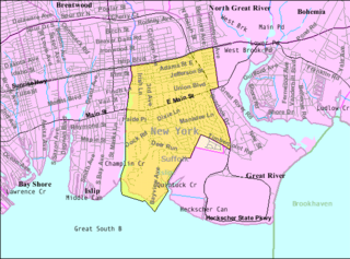
Great River is a suburban hamlet and CDP in the Town of Islip in Suffolk County, New York, United States. It is situated approximately 50 miles (80 km) east of New York City on the South Shore of Long Island, adjoining the Great South Bay, protected from the Atlantic Ocean by Fire Island.

Shelter Island is an island town in Suffolk County, New York, United States, near the eastern end of Long Island. The population was 3,253 at the 2020 census.
An estate is a large parcel of land under single ownership, which would historically generate income for its owner.
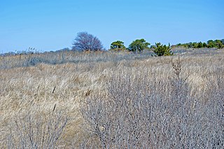
Heckscher State Park is a 1,657-acre (6.71 km2) state park on the shore of the Great South Bay at East Islip in Suffolk County, New York, USA.

Fresh Meadows is a neighborhood in the northeastern section of the New York City borough of Queens. Fresh Meadows used to be part of the broader town of Flushing and is bordered to the north by the Horace Harding Expressway; to the west by Pomonok, St. John's University and the sub-neighborhoods of Hillcrest and Utopia; to the east by Cunningham Park and the Clearview Expressway; and to the south by the Grand Central Parkway.
Mill Basin is a residential neighborhood in southeastern Brooklyn, New York City. It is on a peninsula abutting Jamaica Bay and is bordered by Avenue U on the northwest and the Mill Basin/Mill Island Inlet on its remaining sides. Mill Basin is adjacent to the neighborhood of Bergen Beach to the northeast, Flatlands to the northwest, Marine Park to the southwest, and Floyd Bennett Field and the former Barren Island to the southeast. Mill Basin also contains a subsection called Old Mill Basin, north of Avenue U.

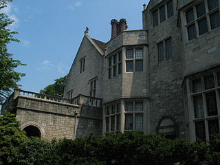
Idle Hour is a former Vanderbilt estate that is located in Oakdale on Long Island in Suffolk County, New York. It was completed in 1901 for William Kissam Vanderbilt. Once part of Dowling College, the mansion is one of the largest houses in the United States.
Planting Fields Arboretum State Historic Park, which includes the Coe Hall Historic House Museum, is an arboretum and state park covering over 400 acres (160 ha) located in the village of Upper Brookville in the town of Oyster Bay, New York.
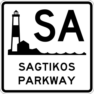
The Sagtikos State Parkway is a 5.14-mile (8.27 km) north–south limited-access parkway in Suffolk County on Long Island, New York, in the United States. It begins at an interchange with the Southern and Heckscher state parkways in the hamlet of West Islip and goes north to a large cloverleaf interchange with the Northern State Parkway in the town of Smithtown, where the Sagtikos ends and the road becomes the Sunken Meadow State Parkway. The parkway comprises the southern half of New York State Route 908K (NY 908K), an unsigned reference route, with the Sunken Meadow State Parkway forming the northern portion. Commercial vehicles are prohibited from using the Sagtikos State Parkway, a restriction that applies to most parkways in the state.
Champlin Creek is on Long Island, located between the hamlets of Islip and East Islip, flowing southward into the Great South Bay between the Seatuck National Wildlife Refuge and The Moorings. The fish and wildlife habitat is an approximate three and one-half mile length of the stream, extending from Knapps Lake, just north of the Main Street, to near its headwaters north of the Southern State Parkway. Champlin Creek is a relatively clean, cold, free-flowing, freshwater stream, generally less than 6 feet (1.8 m) wide, partially vegetated sandy substrate. The creek is bordered by limited areas of wet forest land and suburban residential development. Champlin Creek is one of only a few free-flowing, spring-fed streams on Long Island that have remained in a relatively natural state. This creek provides habitat conditions suitable for natural reproduction by brook trout, and supports one of approximately 6 known wild populations of this species on Long Island. In addition to the native fish populations in Champlin Creek, brown trout and rainbow trout are stocked in the stream by the NYSDEC, provide a recreational fishery of county-level significance. Public access for fishing the area is available along the east side of Knapps Lake and at road crossings.

Harry Bowly Hollins was an American financier, banker, and railroad magnate. He was responsible for organizing the banking and brokerage firm bearing his name, H.B. Hollins & Co. in 1878.

Davis Park is a hamlet in the Town of Brookhaven, Suffolk County, New York, United States. It is located on Fire Island, a barrier island separated from the southern side of Long Island by the Great South Bay off the South Shore village of Patchogue. It lies within the Fire Island National Seashore.

The Apthorp Farm that lay on Manhattan's Upper West Side straddled the old Bloomingdale Road, laid out in 1728, which was re-surveyed as The "Boulevard" – now Upper Broadway. It was the largest block of real estate remaining from the "Bloomingdale District", a rural suburb of 18th-century New York City. Legal disputes between the eventual heirs of the Loyalist Charles Ward Apthorp and purchasers of parcels of real estate held in abeyance the speculative development of the area between 89th and 99th Streets, from Central Park to the Hudson River until final judgment was awarded in July 1910; at that time the New York Times estimated its worth at $125,000,000.
Matthias Nicoll, a.k.a. Nicolls, was the sixth mayor of New York City from 1672 to 1673. He is the patriarch of the Nicoll family, which settled and owned much of Long Island, New York. Numerous place names on the island now bear the Nicoll name.

The Central Islip Psychiatric Center, formerly State Hospital for the Insane, was a state psychiatric hospital in Central Islip, New York, United States from 1889 until 1996.
Winnequaheagh was a Sachem (Chief) of the subsect of the Algonquian peoples known as the Secatogue Tribe. Historians reference Long Island Algonquian Indians as Mohegans as noted on Dutch maps. The farm of the Willets at Islip is called Secatogue Neck, and here is supposed to have been the principal settlement and probably the residence of Winnequaheagh, Sachem of Connetquot in 1683.

Davenport Neck is a peninsula in New Rochelle, New York, extending southwesterly from the mainland into Long Island Sound, and running parallel to the main shore. It divides the city's waterfront into two, with New Rochelle Harbor to the south and southwest, and Echo Bay, to the north and northeast. Glen Island and Neptune Island lie just to the west of the Neck, and Davids and Huckleberry islands lie to the south.

The Lauder Greenway Estate is a 50-acre (20 ha) private property with a French Renaissance mansion in Greenwich, Connecticut. For a time, it was the most expensive home in the history of the United States.
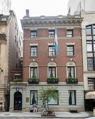
12 West 56th Street is a consular building in the Midtown Manhattan neighborhood of New York City, housing the Consulate General of Argentina in New York City. It is along 56th Street's southern sidewalk between Fifth Avenue and Sixth Avenue. The four-and-a-half story building was designed by McKim, Mead & White in the Georgian Revival style. It was constructed between 1899 and 1901 as a private residence, one of several on 56th Street's "Bankers' Row".
