In modern mapping, a topographic map or topographic sheet is a type of map characterized by large-scale detail and quantitative representation of relief features, usually using contour lines, but historically using a variety of methods. Traditional definitions require a topographic map to show both natural and artificial features. A topographic survey is typically based upon a systematic observation and published as a map series, made up of two or more map sheets that combine to form the whole map. A topographic map series uses a common specification that includes the range of cartographic symbols employed, as well as a standard geodetic framework that defines the map projection, coordinate system, ellipsoid and geodetic datum. Official topographic maps also adopt a national grid referencing system.

The Geographic Names Information System (GNIS) is a database of name and locative information about more than two million physical and cultural features throughout the United States and its territories, Antarctica, and the associated states of the Marshall Islands, Federated States of Micronesia, and Palau. It is a type of gazetteer. It was developed by the United States Geological Survey (USGS) in cooperation with the United States Board on Geographic Names (BGN) to promote the standardization of feature names.

The Kings River is a 132.9-mile (213.9 km) river draining the Sierra Nevada mountain range in central California in the United States. Its headwaters originate along the Sierra Crest in and around Kings Canyon National Park and form the eponymous Kings Canyon, one of the deepest river gorges in North America. The river is impounded in Pine Flat Lake before flowing into the San Joaquin Valley southeast of Fresno. With its upper and middle course in Fresno County, the Kings River diverges into multiple branches in Kings County, with some water flowing south to the old Tulare Lake bed and the rest flowing north to the San Joaquin River. However, most of the water is consumed for irrigation well upstream of either point.

The Atchafalaya River is a 137-mile-long (220 km) distributary of the Mississippi River and Red River in south central Louisiana in the United States. It flows south, just west of the Mississippi River, and is the fifth largest river in North America, by discharge. The name Atchafalaya comes from Choctaw for 'long river', from hachcha, 'river', and falaya, 'long'.

The Kern River, previously Rio de San Felipe, later La Porciuncula, is a Wild and Scenic river in the U.S. state of California, approximately 165 miles (270 km) long. It drains an area of the southern Sierra Nevada mountains northeast of Bakersfield. Fed by snowmelt near Mount Whitney, the river passes through scenic canyons in the mountains and is a popular destination for whitewater rafting and kayaking. It is the southernmost major river system in the Sierra Nevada, and is the only major river in the Sierra that drains in a southerly direction.
The Obey River is a 47.8-mile-long (76.9 km) tributary of the Cumberland River in the U.S. state of Tennessee. It joins the Cumberland River near the town of Celina, which is generally considered to be the Cumberland's head of navigation. Via the Cumberland and Ohio rivers, the Obey River is part of the Mississippi River watershed.

The Clavey River is a tributary of the Tuolumne River in the Sierra Nevada, located in the Stanislaus National Forest and Tuolumne County, California. The river is 31.3 miles (50.4 km) long, and is one of the few undammed rivers on the western slope of the Sierra. Via the Tuolumne River, the Clavey is part of the San Joaquin River watershed.

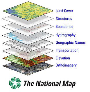
The National Map is a collaborative effort of the United States Geological Survey (USGS) and other federal, state, and local agencies to improve and deliver topographic information for the United States. The purpose of the effort is to provide "...a seamless, continuously maintained set of public domain geographic base information that will serve as a foundation for integrating, sharing, and using other data easily and consistently".

Benchmarking, also known as benchmark hunting, is a hobby activity in which participants find benchmarks. Technically, the term "bench mark" is used only to refer to survey markers that designate a certain elevation, but hobbyists often use the term benchmarks to include triangulation stations or other reference marks. They typically then log their finds online. Like geocaching, the activity has become popular since about 1995, propelled by the availability of on-line data on the location of survey marks and by the rise of hobbyist-oriented websites.
Georeferencing means that the internal coordinate system of a map or aerial photo image can be related to a geographic coordinate system. The relevant coordinate transforms are typically stored within the image file, though there are many possible mechanisms for implementing georeferencing. The most visible effect of georeferencing is that display software can show ground coordinates and also measure ground distances and areas.

Survey markers, also called survey marks, survey monuments, or geodetic marks, are objects placed to mark key survey points on the Earth's surface. They are used in geodetic and land surveying. A benchmark is a type of survey marker that indicates elevation. Horizontal position markers used for triangulation are also known as triangulation stations. Benchmarking is the hobby of "hunting" for these marks.

A "quadrangle" is a topographic map produced by the United States Geological Survey (USGS) covering the United States. The maps are usually named after local physiographic features. The shorthand "quad" is also used, especially with the name of the map; for example, "the Ranger Creek, Texas quad". From approximately 1947-1992, the USGS produced the 7.5 minute series, with each map covering an area one-quarter of the older 15-minute quad series, which it replaced. A 7.5 minute quadrangle map covers an area of 49 to 70 square miles. Both map series were produced via photogrammetric analysis of aerial photography using stereoplotters supplemented by field surveys. These maps employ the 1927 North American Datum (NAD27); conversion or a change in settings is necessary when using a GPS which by default employ the WGS84 geodetic datum. Beginning in 2009, the USGS made available digital versions of 7.5 minute quadrangle maps based on GIS data that use the NAD83 datum, which is typically within one meter of WGS84, or within the uncertainty of most GPS coordinate measurements. On a quadrangle map, the north and south limits are not straight lines, but are actually curved to match Earth's lines of latitude on the standard projection. The east and west limits are usually not parallel as they match Earth's lines of longitude.

The South Fork Kern River is a tributary of the Kern River in the Sierra Nevada of the U.S. state of California. It is one of the southernmost rivers on the western slope of the mountains, and drains a high, relatively dry plateau country of 982 square miles (2,540 km2) along the Sierra Crest. The upper South Fork flows through a series of rugged canyons, but it also drains a flat, marshy valley before joining the Kern River at Lake Isabella.

The United States Geological Survey, abbreviated USGS and formerly simply known as the Geological Survey, is a scientific agency of the United States government. The scientists of the USGS study the landscape of the United States, its natural resources, and the natural hazards that threaten it. The organization's work spans the disciplines of biology, geography, geology, and hydrology. The USGS is a fact-finding research organization with no regulatory responsibility.

Digital geologic mapping is the process by which geological features are observed, analyzed, and recorded in the field and displayed in real-time on a computer or personal digital assistant (PDA). The primary function of this emerging technology is to produce spatially referenced geologic maps that can be utilized and updated while conducting field work.

The Middle Fork Eel River is a major tributary of the Eel River of northwestern California in the United States. It drains a rugged and sparsely populated region of the Yolla Bolly Mountains, part of the California Coast Range, in Trinity and Mendocino Counties. Its watershed comprises roughly 745 square miles (1,930 km2) of land, or 20% of the entire Eel River basin. The river provides groundwater recharge and is used for recreation and for industrial, agricultural and municipal water supply by residents.

The South Fork Kings River is a 44.1-mile (71.0 km) tributary of the Kings River in the Sierra Nevada of Fresno County, California. The river forms part of Kings Canyon, the namesake of Kings Canyon National Park and one of the deepest canyons in North America with a maximum relief of 8,200 feet (2,500 m) from rim to river.
Geographic information systems (GIS) play a constantly evolving role in geospatial intelligence (GEOINT) and United States national security. These technologies allow a user to efficiently manage, analyze, and produce geospatial data, to combine GEOINT with other forms of intelligence collection, and to perform highly developed analysis and visual production of geospatial data. Therefore, GIS produces up-to-date and more reliable GEOINT to reduce uncertainty for a decisionmaker. Since GIS programs are Web-enabled, a user can constantly work with a decision maker to solve their GEOINT and national security related problems from anywhere in the world. There are many types of GIS software used in GEOINT and national security, such as Google Earth, ERDAS IMAGINE, GeoNetwork opensource, and Esri ArcGIS.
The Advanced National Seismic System (ANSS) is a collaboration of the U.S. Geological Survey (USGS) and regional, state, and academic partners that collects and analyzes data on significant earthquakes to provide near real-time information to emergency responders and officials, the news media, and the public. Such information is used to anticipate the likely severity and extent of damage, and to guide decisions on the responses needed.

Rio San Antonio is a tributary of the Conejos River in northern New Mexico and southern Colorado. Via the Conejos River, it is part of the upper Rio Grande system. The river is used extensively for irrigation in its lower course through the southern San Luis Valley.


