The Caribbean large igneous province (CLIP) consists of a major flood basalt, which created this large igneous province (LIP). It is the source of the current large eastern Pacific oceanic plateau, of which the Caribbean-Colombian oceanic plateau is the tectonized remnant. The deeper levels of the plateau have been exposed on its margins at the North and South American plates. The volcanism took place between 139 and 69 million years ago, with the majority of activity appearing to lie between 95 and 88 Ma. The plateau volume has been estimated as on the order of 4 x 10⁶ km3. It has been linked to the Galápagos hotspot.

The Anton Dohrn Seamount is a guyot in the Rockall Trough in the northeast Atlantic. It is 1.8 kilometres (1.1 mi) high and is topped with pinnacles, one of which reaches a depth of 530 metres (1,740 ft). Away from the flat top upon which the pinnacles rest, the slopes fall off steeply into the Rockall Trough and a moat in the sediment that surrounds the seamount.

The Hikurangi Plateau is an oceanic plateau in the South Pacific Ocean east of the North Island of New Zealand. It is part of a large igneous province (LIP) together with Manihiki and Ontong Java, now located 3,000 km (1,900 mi) and 3,500 km (2,200 mi) north of Hikurangi respectively. Mount Hikurangi, in Māori mythology the first part of the North Island to emerge from the ocean, gave its name to the plateau.

The Manihiki Plateau is an oceanic plateau in the south-west Pacific Ocean. The Manihiki Plateau was formed by volcanic activity 126 to 116 million years ago during the mid-Cretaceous period at a triple junction plate boundary called the Tongareva triple junction. Initially at 125 million years ago the Manihiki Plateau formed part of the giant Ontong Java-Manihiki-Hikurangi plateau.
The Walvis Ridge is an aseismic ocean ridge in the southern Atlantic Ocean. More than 3,000 km (1,900 mi) in length, it extends from the Mid-Atlantic Ridge, near Tristan da Cunha and the Gough Islands, to the African coast. The Walvis Ridge is one of few examples of a hotspot seamount chain that links a flood basalt province to an active hotspot. It is also considered one of the most important hotspot tracks because the Tristan Hotspot is one of few primary or deep mantle hotspots.
The Christmas Island Seamount Province is an unusual seamount formation named for Christmas Island, an Australian territory and wildlife reserve that is also part of the chain. The province consists of more than 50 seamounts, up to 4,500 m (14,800 ft) in height, within a 1,080,000 km2 (417,000 sq mi) area.

Musicians Seamounts are a chain of seamounts in the Pacific Ocean, north of the Hawaiian Ridge. There are about 65 seamounts, some of which are named after musicians. These seamounts exist in two chains, one of which has been attributed to a probably now-extinct hotspot called the Euterpe hotspot. Others may have formed in response to plate tectonics associated with the boundary between the Pacific Plate and the former Farallon Plate.
The Discovery Seamounts are a chain of seamounts in the Southern Atlantic Ocean, including Discovery Seamount. The seamounts are 850 kilometres (530 mi) east of Gough Island and once formed islands. Various volcanic rocks as well as glacial dropstones and sediments have been dredged from the Discovery Seamounts.
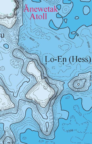
Lo-En or Hess is an Albian–Campanian guyot in the Marshall Islands. One among a number of seamounts in the Pacific Ocean, it was probably formed by a hotspot in what is present-day French Polynesia. Lo-En lies southeast of Eniwetok which rises above sea level, and Lo-En is almost connected to it through a ridge.

The Rarotonga hotspot is a volcanic hotspot in the southern Pacific Ocean. The hotspot is claimed to be responsible for the formation of Rarotonga and some volcanics of Aitutaki but an alternative explanation for these islands most recent volcanics has not been ruled out. Recently alternatives to hotspot activity have been offered for several other intra-plate volcanoes that may have been associated with the Rarotonga hotspot hypothesis.

Horizon Guyot is a presumably Cretaceous guyot (tablemount) in the Mid-Pacific Mountains, Pacific Ocean. It is an elongated ridge, over 300 kilometres (190 mi) long and 4.3 kilometres (2.7 mi) high, that stretches in a northeast–southwest direction and has two flat tops; it rises to a minimum depth of 1,443 metres (4,730 ft). The Mid-Pacific Mountains lie west of Hawaii and northeast of the Line Islands.
Erimo Seamount is a seamount off Hokkaido, Japan. Located close to the intersection between the Kuril-Kamchatka and Japan Trenches, it is in the process of being subducted. The Cretaceous seamount formed 100-120 million years ago and is covered by a limestone cap. Tiltmeters have been installed on its top.
A lava balloon is a gas-filled bubble of lava that floats on the sea surface. It can be up to several metres in size. When it emerges from the sea, it is usually hot and often steaming. After floating for some time it fills with water and sinks again.
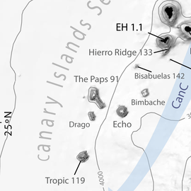
Echo Bank is an underwater mountain, part of the Canary Islands Seamount Province and located southwest of the Canary Islands. Of uncertain geologic origin, it is part of a larger cluster of submarine mountains and rises to a depth of 255 metres (837 ft) below sea level. It has a flat top, indicating that it formerly might have emerged from the sea.
Tropic Seamount is a Cretaceous seamount, part of the Canary Islands Seamount Province. It is located west of the Western Sahara's coastline and southwest of the Canary Islands, north of Cape Verde. It is one of a number of seamounts in this part of the Atlantic Ocean, probably formed by volcanic processes triggered by the proximity to the African continent. Tropic Seamount is located at a depth of 970 metres (3,180 ft) and has a summit platform with an area of 120 square kilometres (46 sq mi).

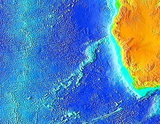
The Canary Islands Seamount Province (CISP) is located in the Atlantic Ocean between 23º and 33º north. It comprises the seven major islands of the Canary Islands archipelago, the two islets of the Savage Islands and 16 seamounts scattered along an area of 540,000 km2 parallel to the northwestern coastline of the African Continent. Besides its geographical distribution, the components of the province share a series of geochemical similarities.

The geology of the Canary Islands is dominated by volcanic rock. The Canary Islands and some seamounts to the north-east form the Canary Volcanic Province, whose volcanic history started about 70 million years ago. The Canary Islands region is still volcanically active. The most recent volcanic eruption on land occurred in 2021 and the most recent underwater eruption was in 2011-12.

Coral Patch Seamount is a seamount between Madeira and mainland Portugal in the North Atlantic Ocean. It is an elongated 120 kilometres (75 mi) long and 70 kilometres (43 mi) wide mountain that rises to a depth of about 645 metres (2,116 ft), with nine volcanic cones on its summit. It has steeper southern slopes and a gentle northern slope. To its west lies Ampére Seamount, and together with several neighbouring seamounts it is one of the Horseshoe Seamounts.
Henry Seamount is a seamount of Cretaceous age southeast of El Hierro in the Canary Islands. It is 660 metres (2,170 ft) high above the seafloor and covered with sediments. Despite its old age, it shows evidence of recent eruptions and of hydrothermal activity in the last 3,350 years. This activity may be either mediated by groundwater flow from El Hierro or by recent eruptions of Henry Seamount.

Tagoro is a submarine volcano located off the southern coast of the island of El Hierro, in the Atlantic Ocean. It is part of the Canary Islands Seamount Province.