The ionosphere is the ionized part of the upper atmosphere of Earth, from about 48 km (30 mi) to 965 km (600 mi) above sea level, a region that includes the thermosphere and parts of the mesosphere and exosphere. The ionosphere is ionized by solar radiation. It plays an important role in atmospheric electricity and forms the inner edge of the magnetosphere. It has practical importance because, among other functions, it influences radio propagation to distant places on Earth.
In telecommunication, the term critical frequency has the following meanings:
The F region of the ionosphere is home to the F layer of ionization, also called the Appleton–Barnett layer, after the English physicist Edward Appleton and New Zealand physicist and meteorologist Miles Barnett. As with other ionospheric sectors, 'layer' implies a concentration of plasma, while 'region' is the volume that contains the said layer. The F region contains ionized gases at a height of around 150–800 km above sea level, placing it in the Earth's thermosphere, a hot region in the upper atmosphere, and also in the heterosphere, where chemical composition varies with height. Generally speaking, the F region has the highest concentration of free electrons and ions anywhere in the atmosphere. It may be thought of as comprising two layers, the F1 and F2 layers.

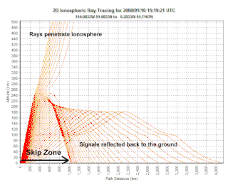
A skip zone, also called a silent zone or zone of silence, is a region where a radio transmission can not be received. The zone is located between regions both closer and farther from the transmitter where reception is possible.
The thermosphere is the layer in the Earth's atmosphere directly above the mesosphere and below the exosphere. Within this layer of the atmosphere, ultraviolet radiation causes photoionization/photodissociation of molecules, creating ions; the thermosphere thus constitutes the larger part of the ionosphere. Taking its name from the Greek θερμός meaning heat, the thermosphere begins at about 80 km (50 mi) above sea level. At these high altitudes, the residual atmospheric gases sort into strata according to molecular mass. Thermospheric temperatures increase with altitude due to absorption of highly energetic solar radiation. Temperatures are highly dependent on solar activity, and can rise to 2,000 °C (3,630 °F) or more. Radiation causes the atmospheric particles in this layer to become electrically charged, enabling radio waves to be refracted and thus be received beyond the horizon. In the exosphere, beginning at about 600 km (375 mi) above sea level, the atmosphere turns into space, although, by the judging criteria set for the definition of the Kármán line (100 km), most of the thermosphere is part of space. The border between the thermosphere and exosphere is known as the thermopause.

Radio waves are a type of electromagnetic radiation with the longest wavelengths in the electromagnetic spectrum, typically with frequencies of 300 gigahertz (GHz) and below. At 300 GHz, the corresponding wavelength is 1 mm ; at 30 Hz the corresponding wavelength is 10,000 kilometers. Like all electromagnetic waves, radio waves in a vacuum travel at the speed of light, and in the Earth's atmosphere at a close, but slightly lower speed. Radio waves are generated by charged particles undergoing acceleration, such as time-varying electric currents. Naturally occurring radio waves are emitted by lightning and astronomical objects, and are part of the blackbody radiation emitted by all warm objects.

Space weather is a branch of space physics and aeronomy, or heliophysics, concerned with the time varying conditions within the Solar System, including the solar wind, emphasizing the space surrounding the Earth, including conditions in the magnetosphere, ionosphere, thermosphere, and exosphere. Space weather is distinct from but conceptually related to the terrestrial weather of the atmosphere of Earth. The term space weather was first used in the 1950s and came into common usage in the 1990s. Later, it was generalized to a "Space Climate" research discipline which focuses on general behaviors of longer and larger-scale variabilities and effects.

Very low frequency or VLF is the ITU designation for radio frequencies (RF) in the range of 3–30 kHz, corresponding to wavelengths from 100 to 10 km, respectively. The band is also known as the myriameter band or myriameter wave as the wavelengths range from one to ten myriameters. Due to its limited bandwidth, audio (voice) transmission is highly impractical in this band, and therefore only low data rate coded signals are used. The VLF band is used for a few radio navigation services, government time radio stations and for secure military communication. Since VLF waves can penetrate at least 40 meters (131 ft) into saltwater, they are used for military communication with submarines.
Radio propagation is the behavior of radio waves as they travel, or are propagated, from one point to another in vacuum, or into various parts of the atmosphere. As a form of electromagnetic radiation, like light waves, radio waves are affected by the phenomena of reflection, refraction, diffraction, absorption, polarization, and scattering. Understanding the effects of varying conditions on radio propagation has many practical applications, from choosing frequencies for amateur radio communications, international shortwave broadcasters, to designing reliable mobile telephone systems, to radio navigation, to operation of radar systems.

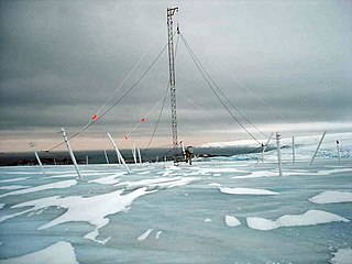
An ionosonde, or chirpsounder, is a special radar for the examination of the ionosphere. The basic ionosonde technology was invented in 1925 by Gregory Breit and Merle A. Tuve and further developed in the late 1920s by a number of prominent physicists, including Edward Victor Appleton. The term ionosphere and hence, the etymology of its derivatives, was proposed by Robert Watson-Watt.
Non-line-of-sight (NLOS) radio propagation occurs outside of the typical line-of-sight (LOS) between the transmitter and receiver, such as in ground reflections. Near-line-of-sight conditions refer to partial obstruction by a physical object present in the innermost Fresnel zone.
Near vertical incidence skywave, or NVIS, is a skywave radio-wave propagation path that provides usable signals in the medium distances range — usually 0–650 km. It is used for military and paramilitary communications, broadcasting, especially in the tropics, and by radio amateurs for nearby contacts circumventing line-of-sight barriers. The radio waves travel near-vertically upwards into the ionosphere, where they are refracted back down and can be received within a circular region up to 650 km from the transmitter. If the frequency is too high, refraction is insufficient to return the signal to earth and if it is too low, absorption in the ionospheric D layer may reduce the signal strength.
The Earth–ionosphere waveguide refers to the phenomenon in which certain radio waves can propagate in the space between the ground and the boundary of the ionosphere. Because the ionosphere contains charged particles, it can behave as a conductor. The earth operates as a ground plane, and the resulting cavity behaves as a large waveguide.

Total electron content (TEC) is an important descriptive quantity for the ionosphere of the Earth. TEC is the total number of electrons integrated between two points, along a tube of one meter squared cross section, i.e., the electron columnar number density. It is often reported in multiples of the so-called TEC unit, defined as TECU=1016el/m2≈1.66×10−8 mol⋅m−2.

Radio occultation (RO) is a remote sensing technique used for measuring the physical properties of a planetary atmosphere or ring system.

C/NOFS, or Communications/Navigation Outage Forecasting System was an USAF satellite developed by the Air Force Research Laboratory (AFRL) Space Vehicles Directorate to investigate and forecast scintillations in the Earth's ionosphere. It was launched by an Orbital Sciences Corporation Pegasus-XL launch vehicle at 17:02:48 UTC on 16 April 2008 and decayed on 28 November 2015.
This is an index to articles about terms used in discussion of radio propagation.

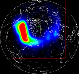
Ionospheric storms are storms which contain varying densities of energised electrons produced from the sun. They are categorised into positive and negative storms, where positive storms have a high density of electrons and negative storms contain a lower density. This is measured in total electron content (TEC), and is a key variable used in data to record and compare the intensities of ionospheric storms. Ionospheric storms are caused by geomagnetic storms.

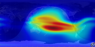
International Reference Ionosphere (IRI) is a common permanent scientific project of the Committee on Space Research (COSPAR) and the International Union of Radio Science (URSI) started 1968/69. It is the international standard empirical model for the terrestrial ionosphere since 1999. For a specified geographic location, time, and date, IRI provides average monthly values for electron density, electron temperature and ion temperature, and the molecular composition of the ions in the range of altitudes from 50 km to 2000 km. The latest standard is IRI-2012. A new version, IRI-2016, has since been released. The IRI has been extended to plasmasphere in the IRI-Plas model.

Louis Miles Muggleton, FIET was a South African-born British Ionospheric Physicist and Electrical Engineer. Building on the work of Sir Edward Appleton in 1975 Muggleton's seminal work provided the international standard ITU model of radio wave absorption and reflection of the Heaviside layer of the Ionosphere. This model was based on jointly published work with Stamatis Kouris from the early 1970s.


