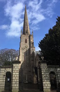
St Mary's Priory Church, in Whitecross Street, Monmouth, Monmouthshire, Wales, is an Anglican church founded as a Benedictine priory in 1075. The current church dates mostly from the 18th and 19th centuries. It was designated a Grade II* listed building in 1952. It is one of 24 buildings on the Monmouth Heritage Trail.

Llanarth Court is a late-18th-century country house with substantial 19th-century alterations in Llanarth, Monmouthshire, Wales. The court was built for the Jones family of Treowen and was subsequently the home of Ivor Herbert, 1st Baron Treowen, whose family still owns much of the Llanarth estate, although not the court itself. The court is a Grade II* listed building and is now a private hospital.

Monmouthshire is a county and principal area of Wales. It borders Torfaen and Newport to the west; Herefordshire and Gloucestershire to the east; and Powys to the north. The largest town is Abergavenny, with other large settlements being Chepstow, Monmouth, and Usk. The present county was formed under the Local Government (Wales) Act 1994, and comprises some sixty percent of the historic county. Between 1974 and 1996, the county was known by the ancient title of Gwent, recalling the medieval Welsh kingdom. The county is 850 km2 in extent, with a population of 95,200 as of 2020.
Monmouthshire is a county and principal area of Wales. It borders Torfaen and Newport to the west; Herefordshire and Gloucestershire to the east; and Powys to the north. The largest town is Abergavenny, with the other major towns being Chepstow, Monmouth, and Usk. The county is 850 km2 in extent, with a population of 95,200 as of 2020. The present county was formed under the Local Government (Wales) Act 1994, and comprises some sixty percent of the historic county. Between 1974 and 1996, the county was known by the ancient title of Gwent, recalling the medieval Welsh kingdom. In his essay on local government in the fifth and final volume of the Gwent County History, Robert McCloy suggests that the governance of "no county in the United Kingdom in the twentieth century was so transformed as that of Monmouthshire".

The Procurator's House in Magor, Monmouthshire, Wales, is a large, ruined mansion of the sixteenth-century, standing next to St Mary's Church in the centre of the village. Although of ecclesiastical origin, it is unlikely the present house was ever occupied by a Procurator, who was a church official responsible for the collection of tithes. The lands owned by the Church of St Mary were controlled by the Abbey of Anagni, in Italy, in the Middle Ages and it is possible that an earlier building on the same site housed the abbey's procurator. The current building post-dates ownership by the abbey, and was constructed when the avowson of St Mary's was controlled by Tintern Abbey. The building is mentioned in a document of 1585, when it is referred to as "the mansion house belonging to the vicarage of Magor." This accounts for the two alternative names for the ruin, Magor Mansion and The Church House.

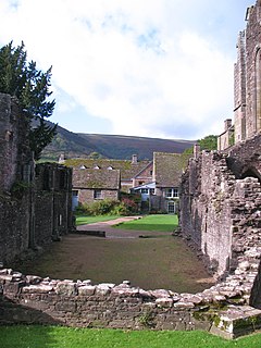
Court Farm Barn, Llanthony Priory, Monmouthshire is a barn of late medieval origins which forms part of a group of historic buildings in the priory complex. It is a Grade I listed building.
Church Farmhouse, Kemeys Commander, Monmouthshire is a former parsonage dating from the mid-16th century. The farmhouse and the attached barn are Grade II* listed buildings.

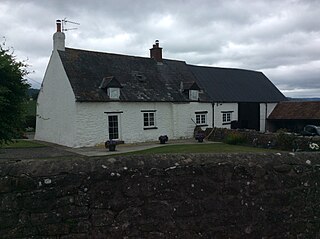
Ty-Hwnt-y-Bwlch Farmhouse,, Cwmyoy, Monmouthshire is a farmhouse in the north of the county dating from the late 16th century. Located on the hillside above the Church of St Martin, it is a Grade II* listed building.
Newhouse Farmhouse, Llanvetherine, Monmouthshire is a farmhouse dating from the late-16th century. It is a Grade II* listed building. Its associated barns and stable block have their own Grade II listings.

The Corn Barn, Stable and Cider House at Great Tre-Rhew Farm, Llantilio Crossenny, Monmouthshire form part of "one of the most completely surviving farmsteads in the county". Constructed in the late 17th century, the corn barn is an eight-bay structure with the stable and cider house forming two, gabled, linked additions. The whole is a Grade II* listed structure. The other buildings that comprise the farmstead include the farmhouse, a granary and brewhouse, and a shelter shed, all of which have their own Grade II listings.
Llanddewi Court, Llanddewi Skirrid, Monmouthshire, Wales, is a Grade II* listed house dating from the late 16th century. It is an example of a "double-house", a building in two sections, originally without interconnections, and designed to accommodate two families.

Great House, Llanarth, Monmouthshire is a farmhouse dating from the late-16th century. Extended in the mid-17th century and little altered thereafter, it is a Grade II* listed building. The detached barn range has its own Grade II listing.

Pentwyn, Llanllowell, Monmouthshire is a farmhouse dating from the mid-16th century. The house is Grade II* listed, with the adjacent barn having its own Grade II listing.
Court Farmhouse, Llanthony, Monmouthshire is a farmhouse of late medieval origins. It may have originally been lodgings for the Prior of Llanthony. Following the Dissolution of the Monasteries the building became a farmhouse. In the 19th century, the Llanthony Estate was bought by Walter Savage Landor who undertook remodelling. The farmhouse is Grade II* listed, with the adjacent barn, Court Farm Barn, having a separate Grade I listing.

Cwm Bwchel Farmhouse, Llanthony, Monmouthshire is a farmhouse dating from the late-Medieval period. It carries a date stone of 1694, which probably refers to a period of reconstruction. The farmhouse is Grade II* listed and a number of the ancillary buildings on the farmstead have their own Grade II listings.

The barn, stable and granary at Cwrt y Brychan , Llansoy, Monmouthshire are a range of farm buildings constructed in the 16th century. The origins are the site are ancient and the court is historically connected with the kingdom of Brycheiniog. The complex has a Grade II* listing, with the court having a separate Grade II listing.

Blaengavenny Farmhouse, Llanvihangel Crucorney, Monmouthshire is a farmhouse of late medieval origins. It is a Grade II listed building. Its adjacent barn and granary have separate Grade II listings.

Persondy , Mamhilad, Monmouthshire is a former parsonage dating from the late 16th century. It is a Grade II* listed building. The adjacent barn, now a separate residence called Ysguborwen, has its own Grade II listing.

Church Farmhouse, Caldicot, Monmouthshire is a substantial grange building which was a working farmhouse before 1205. It is connected to both Llanthony Prima in Monmouthshire and Llanthony Secunda in Gloucester. It was established as a grange farm for Llanthony Secunda Priory in the 12th century with the lands in Caldicot being given to the monastery in 1137. It is a Grade II* listed building. The adjacent barn has its own Grade II listing.

Lower Celliau,, Llangattock Lingoed, Monmouthshire is a farmhouse dating from the 16th century. It is a Grade II* listed building. The adjacent barn and shelter, and cowhouse and stable have their own Grade II listings.


