
The Quad Cities is a region of five cities in the U.S. states of Iowa and Illinois: Davenport and Bettendorf in southeastern Iowa, and Rock Island, Moline, and East Moline in northwestern Illinois. These cities are the center of the Quad Cities metropolitan area, which as of 2013 had a population estimate of 383,781 and a Combined Statistical Area (CSA) population of 474,937, making it the 90th-largest CSA in the nation.

A towpath is a road or trail on the bank of a river, canal, or other inland waterway. The purpose of a towpath is to allow a land vehicle, beasts of burden, or a team of human pullers to tow a boat, often a barge. This mode of transport was common where sailing was impractical due to tunnels and bridges, unfavourable winds, or the narrowness of the channel.

The Illinois and Michigan Canal connected the Great Lakes to the Mississippi River and the Gulf of Mexico. In Illinois, it ran 96 miles (154 km) from the Chicago River in Bridgeport, Chicago to the Illinois River at LaSalle-Peru. The canal crossed the Chicago Portage, and helped establish Chicago as the transportation hub of the United States, before the railroad era. It was opened in 1848. Its function was largely replaced by the wider and shorter Chicago Sanitary and Ship Canal in 1900, and it ceased transportation operations with the completion of the Illinois Waterway in 1933.

The Illinois River is a principal tributary of the Mississippi River and is approximately 273 miles (439 km) long. Located in the U.S. state of Illinois, the river drains a large section of central Illinois, with a drainage basin of 28,756.6 square miles (74,479 km2). The drainage basin extends into Wisconsin, Indiana, and a very small area of southwestern Michigan.

LaSalle County is located in the North Central region of the U.S. state of Illinois; it has an estimated population of 108,669 as of 2019 and its county seat and largest city is Ottawa.

DePue is a village in Bureau County, Illinois, United States. The population was 1,838 at the 2010 census. It is part of the Ottawa Micropolitan Statistical Area.

Seneca is a village in LaSalle and Grundy counties in the U.S. state of Illinois. The population was 2,371 at the 2010 census.
LaSalle is a city in LaSalle County, Illinois, United States, located at the intersection of Interstates 39 and 80. It is part of the Ottawa, IL Micropolitan Statistical Area. Originally platted in 1837 over one square mile, the city's boundaries have grown to 12 sq mi (31 km2). City boundaries extend from the Illinois River and Illinois and Michigan Canal to a mile north of Interstate 80 and from the city of Peru on the west to the village of North Utica on the east. Starved Rock State Park is located approximately 5 mi (8 km) to the east. The population was 9,609 at the 2010 census, and was estimated to have decreased to 8,986 by July 2019. LaSalle and its twin city, Peru, make up the core of the Illinois Valley. Due to their combined dominance of the zinc processing industry in the early 1900s, they were collectively nicknamed "Zinc City."

Streator is a city in LaSalle and Livingston counties in the U.S. state of Illinois. The city is situated on the Vermilion River approximately 81 miles (130 km) southwest of Chicago in the prairie and farm land of north-central Illinois. It is the center of the geographic region known as Streatorland. According to the 2010 census, the population of Streator was 13,710.

The Chesapeake and Ohio Canal, abbreviated as the C&O Canal and occasionally called the "Grand Old Ditch," operated from 1831 until 1924 along the Potomac River from Washington, D.C., to Cumberland, Maryland. The canal's principal cargo was coal from the Allegheny Mountains.

The Royal Canal is a canal originally built for freight and passenger transportation from the River Liffey in Dublin to Longford in Ireland. The canal fell into disrepair in the late 20th century, but much of the canal has since been restored for navigation. The length of the canal to the River Shannon was reopened on 1 October 2010, but the final spur branch of the canal to Longford Town remains closed.
The Shrewsbury Canal was a canal in Shropshire, England. Authorised in 1793, the main line from Trench to Shrewsbury was fully open by 1797, but it remained isolated from the rest of the canal network until 1835, when the Birmingham and Liverpool Junction Canal built the Newport Branch from Norbury Junction to a new junction with the Shrewsbury Canal at Wappenshall. After ownership passed to a series of railway companies, the canal was officially abandoned in 1944; many sections have disappeared, though some bridges and other structures can still be found. There is an active campaign to preserve the remnants of the canal and to restore the Norbury to Shrewsbury line to navigation.

The Hennepin Canal State Trail, also just called the Hennepin Canal, is an abandoned waterway in northwest Illinois, between the Mississippi River at Rock Island and the Illinois River near Hennepin. The entire canal is listed on the National Register of Historic Places.

Providence is a ghost town on the north side of the Maumee River in southern Providence Township, Lucas County, Ohio, United States, about 24 miles (39 km) southwest of Toledo. After suffering a destructive fire and a cholera epidemic in mid-19th century, the village was abandoned. In this period, canal traffic had also fallen off.

The 17th congressional district of Illinois is represented by Democrat Cheri Bustos. It includes most of the northwestern portion of the state, with most of its population living on the Illinois side of the Quad Cities, as well as parts of Peoria and Rockford.

Northern Illinois is a region generally covering the northern third of the U.S. state of Illinois.
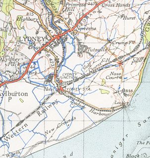
This one-mile canal in Gloucestershire runs inland from the River Severn to Lydney. It was opened in 1813 to trans-ship iron and coal from the Forest of Dean. It was once connected by a horse drawn tramroad to Pidcock's Canal which brought materials down to the wharves by tub-boat.

The Susquehanna and Tidewater Canal between Wrightsville, Pennsylvania, and Havre de Grace, Maryland, at the head of Chesapeake Bay, provided an interstate shipping alternative to 19th-century arks, rafts, and boats plying the difficult waters of the lower Susquehanna River. Built between 1836 and 1840, it ran 43 miles (69 km) along the west bank of the river and rendered obsolete an older, shorter canal along the east bank. Of its total length, 30 miles (48 km) were in Pennsylvania and 13 miles (21 km) in Maryland. Though rivalry between Philadelphia, Pennsylvania, and Baltimore, Maryland, delayed its construction, the finished canal brought increased shipments of coal and other raw materials to both cities from Pennsylvania's interior. Competition from railroads was a large factor in the canal's decline after 1855. Canal remnants, including a lock keeper's house, have been preserved in Maryland, and locks 12 and 15 have been preserved in Pennsylvania. A copy of a detailed survey blueprint of the entire canal system including structures and property ownership details was donated by the Safe Harbor Water Power Corporation to Millersville University. The survey consists of 67 pages, 98 x 30 cm. and is undated but the assumption is the original was created while the canal was in use.

The Mersey and Irwell Navigation was a river navigation in North West England, which provided a navigable route from the Mersey estuary to Salford and Manchester, by improving the course of the River Irwell and the River Mersey. Eight locks were constructed between 1724 and 1734, and the rivers were improved by the construction of new cuts several times subsequently. Use of the navigation declined from the 1870s, and it was ultimately superseded by the Manchester Ship Canal, the construction of which destroyed most of the Irwell section of the navigation and the long cut between Latchford and Runcorn.

