Related Research Articles

Thebes, known to the ancient Egyptians as Waset, was an ancient Egyptian city located along the Nile about 800 kilometers (500 mi) south of the Mediterranean. Its ruins lie within the modern Egyptian city of Luxor. Thebes was the main city of the fourth Upper Egyptian nome and was the capital of Egypt for long periods during the Middle Kingdom and New Kingdom eras. It was close to Nubia and the Eastern Desert, with its valuable mineral resources and trade routes. It was a cult center and the most venerated city during many periods of ancient Egyptian history. The site of Thebes includes areas on both the eastern bank of the Nile, where the temples of Karnak and Luxor stand and where the city was situated; and the western bank, where a necropolis of large private and royal cemeteries and funerary complexes can be found. In 1979, the ruins of ancient Thebes were classified by UNESCO as a World Heritage Site.

Hannu, Hennu or Henenu was an Egyptian noble, serving as m-r-pr "majordomo" to Mentuhotep III in the 20th century BC. He reportedly re-opened the trade routes to Punt and Libya for the Middle Kingdom of Egypt. He was buried in a tomb in Deir el-Bahri, in the Theban Necropolis, which has been catalogued as TT313.

Dakhla Oasis, is one of the seven oases of Egypt's Western Desert. Dakhla Oasis lies in the New Valley Governorate, 350 km (220 mi.) from the Nile and between the oases of Farafra and Kharga. It measures approximately 80 km (50 mi) from east to west and 25 km (16 mi) from north to south.

Sehertawy Intef I was a local nomarch at Thebes during the early First Intermediate Period and the first member of the 11th Dynasty to lay claim to a Horus name. Intef reigned from 4 to 16 years c. 2120 BC or c. 2070 BC during which time he probably waged war with his northern neighbor, the Coptite nomarch Tjauti. Intef was buried in a saff tomb at El-Tarif, known today as Saff el-Dawaba.
Proto-Sinaitic is considered the earliest trace of alphabetic writing and the common ancestor of both the Ancient South Arabian script and the Phoenician alphabet, which led to many modern alphabets including the Greek alphabet. According to common theory, Canaanites or Hyksos who spoke a Semitic language repurposed Egyptian hieroglyphs to construct a different script. The script is attested in a small corpus of inscriptions found at Serabit el-Khadim in the Sinai Peninsula, Egypt, dating to the Middle Bronze Age.

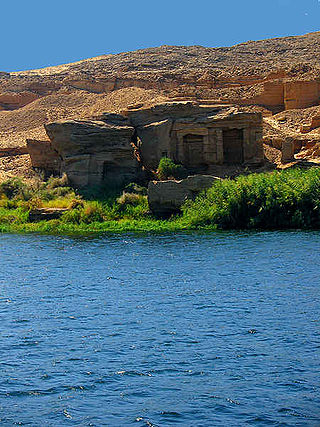
The Kharga Oasislit. 'the outer'; Coptic: (ϯ)ⲟⲩⲁϩ ⲛ̀ϩⲏⲃ(di)wah enhib, "Oasis of Hib", (ϯ)ⲟⲩⲁϩ ⲙ̀ⲯⲟⲓ(di)wah empsoi "Oasis of Psoi") is the southernmost of Egypt's five western oases. It is located in the Western Desert, about 200 km to the west of the Nile valley. "Kharga" or "El Kharga" is also the name of a major town located in the oasis, the capital of New Valley Governorate. The oasis, which was known as the 'Southern Oasis' to the Ancient Egyptians and Oasis Magna to the Romans, is the largest of the oases in the Libyan desert of Egypt. It is in a depression about 160 km long and from 20 km to 80 km wide. Its population is 67,700 (2012).
The year 1999 in archaeology involved some significant events.

Nubkheperre Intef was an Egyptian king of the Seventeenth Dynasty of Egypt at Thebes during the Second Intermediate Period, when Egypt was divided by rival dynasties including the Hyksos in Lower Egypt.

The Valley of the Kings, also known as the Valley of the Gates of the Kings, is a valley in Egypt where, for a period of nearly 500 years from the 16th to 11th century BC, rock-cut tombs were excavated for the pharaohs and powerful nobles of the New Kingdom.
Herbert Eustis Winlock was an American Egyptologist and archaeologist, employed by the Metropolitan Museum of Art for his entire career. Between 1906 and 1931 he took part in excavations at El-Lisht, Kharga Oasis and around Luxor, before serving as director of the Metropolitan Museum from 1932 to 1939.
The stone quarries of ancient Egypt once produced quality stone for the construction of decorative monuments such as sculptures and obelisks. These quarries are now recognised archaeological sites. Eighty percent of the ancient quarry sites are in the Nile valley; some of them have disappeared under the waters of Lake Nasser and some others were lost due to modern mining activity.

Wadi Hammamat is a dry river bed in Egypt's Eastern Desert, about halfway between Al-Qusayr and Qena. It was a major mining region and trade route east from the Nile Valley in ancient times, and three thousand years of rock carvings and graffiti make it a major scientific and tourist site today.
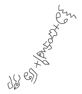
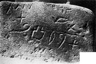
Wadi el-Hol is a valley on the Farshut Road, north-west of Luxor on the Qena Bend, situated on the west bank of the river Nile in Egypt. Rock inscriptions in the valley appear to show the oldest examples of phonetic alphabetic writing discovered to date.
John Coleman Darnell is an American Egyptologist.
Colleen Darnell is an American Egyptologist. Her areas of expertise include Late Period uses of the Underworld Books, ancient Egyptian military history, the literature of New Kingdom Egypt, and Egyptian revival history.
Tjauti was an ancient Egyptian official who lived at the end of the Eighth Dynasty, around 2150 BC. He is known from a number of sources providing evidence that he was an important figure in the Coptic Nome in Upper Egypt. However, the sources are often broken and the figure of Tjauti remains therefore enigmatic. The most important objects naming Tjauti are the fragments of a false door found near Khozam where he is called overseer of Upper Egypt, which was one of the most important titles in the Old Kingdom. He is also called the one who fills the heart of the king showing some close connection to the royal court. A person called Tjauti-iqer also appears in several inscriptions in the Wadi Hammamat, reporting the transport of stones: Tjauti-iqer seems to be a variant of the name. The inscriptions also mentions the god's father Idy, who was the son of Shemay. Shemay lived at the end of the Eighth Dynasty providing also a date for Tjauti to about the same period.
F. W. "Chip" Dobbs-Allsopp is a biblical scholar, epigrapher, and literary theorist. Currently professor of Old Testament, or Hebrew Bible, at Princeton Theological Seminary, he has taught and written extensively on Semitic languages, the origins of alphabetic writing, biblical poetry, poetics, and literary criticism.
Gebel Tjauti is a rock formation in Egypt. The rock is named after Tjauti, an ancient Egyptian official who lived at the end of the Eighth Dynasty, around 2150 BC.

Darb El Arba'īn is the easternmost of the great north–south Trans-Saharan trade routes. The Darb El Arba'īn route was used to move trade goods, livestock and slaves via a chain of oases from the interior of Africa to portage on the Nile River and thence to the rest of the world.
References
- 1 2 3 4 5 6 Wilford, John Noble. "Desert Roads Lead to Discovery in Egypt", The New York Times , September 6, 2010. Accessed May 13, 2020.
- ↑ Pringle, Heather. "The Lost City: A discovery in the desert could rewrite the history of ancient Egypt.", Yale Alumni Magazine, September / October 2010. Accessed May 13, 2020.
- ↑ Theban Desert Road Survey and Yale Toshka Desert Survey, Yale University. Accessed May 13, 2020.
- ↑ Baker, Dorie. "Finding sheds new light on the alphabet's origins", Yale Bulletin & Calendar, December 13, 1999-January 17, 2000. Volume 28, Number 16. Accessed May 13, 2020.
- ↑ Baker, Dorie. "Ancient 'Lost' Egyptian City Discovered By Yale Archaeologists", Yale University press release dated August 26, 2010. Accessed May 13, 2020.