Related Research Articles

Alba Mons is a volcano located in the northern Tharsis region of the planet Mars. It is the biggest volcano on Mars in terms of surface area, with volcanic flow fields that extend for at least 1,350 km (840 mi) from its summit. Although the volcano has a span comparable to that of the United States, it reaches an elevation of only 6.8 km (22,000 ft) at its highest point. This is about one-third the height of Olympus Mons, the tallest volcano on the planet. The flanks of Alba Mons have very gentle slopes. The average slope along the volcano's northern flank is 0.5°, which is over five times lower than the slopes on the other large Tharsis volcanoes. In broad profile, Alba Mons resembles a vast but barely raised welt on the planet's surface. It is a unique volcanic structure with no counterpart on Earth or elsewhere on Mars.

The atmosphere of Mars is the layer of gases surrounding Mars. It is primarily composed of carbon dioxide (95%), molecular nitrogen (2.8%), and argon (2%). It also contains trace levels of water vapor, oxygen, carbon monoxide, hydrogen, and noble gases. The atmosphere of Mars is much thinner than Earth's. The average surface pressure is only about 610 pascals (0.088 psi) which is less than 1% of the Earth's value. The currently thin Martian atmosphere prohibits the existence of liquid water on the surface of Mars, but many studies suggest that the Martian atmosphere was much thicker in the past. The higher density during spring and fall is reduced by 25% during the winter when carbon dioxide partly freezes at the pole caps. The highest atmospheric density on Mars is equal to the density found 35 km (22 mi) above the Earth's surface and is ≈0.020 kg/m3. The atmosphere of Mars has been losing mass to space since the planet's core slowed down, and the leakage of gases still continues today.
In astronomy, the geometric albedo of a celestial body is the ratio of its actual brightness as seen from the light source to that of an idealized flat, fully reflecting, diffusively scattering (Lambertian) disk with the same cross-section.

The Compact Reconnaissance Imaging Spectrometer for Mars (CRISM) is a visible-infrared spectrometer aboard the Mars Reconnaissance Orbiter searching for mineralogic indications of past and present water on Mars. The CRISM instrument team comprises scientists from over ten universities and led by principal investigator Scott Murchie. CRISM was designed, built, and tested by the Johns Hopkins University Applied Physics Laboratory.
The Bond albedo, named after the American astronomer George Phillips Bond (1825–1865), who originally proposed it, is the fraction of power in the total electromagnetic radiation incident on an astronomical body that is scattered back out into space.
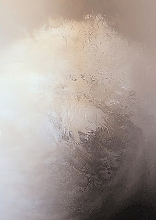
Planum Australe is the southern polar plain on Mars. It extends southward of roughly 75°S and is centered at 83.9°S 160.0°E. The geology of this region was to be explored by the failed NASA mission Mars Polar Lander, which lost contact on entry into the Martian atmosphere.

The climate of Mars has been a topic of scientific curiosity for centuries, in part because it is the only terrestrial planet whose surface can be directly observed in detail from the Earth with help from a telescope.

Volcanism on Io, a moon of Jupiter, is represented by the presence of volcanoes, volcanic pits and lava flows on the moon's surface. Its volcanic activity was discovered in 1979 by Voyager 1 imaging scientist Linda Morabito. Observations of Io by passing spacecraft and Earth-based astronomers have revealed more than 150 active volcanoes. Up to 400 such volcanoes are predicted to exist based on these observations. Io's volcanism makes the satellite one of only four known currently volcanically active worlds in the Solar System.

The surface of the planet Mars appears reddish from a distance because of rusty dust suspended in the atmosphere. From close up, it looks more of a butterscotch, and other common surface colors include golden, brown, tan, and greenish, depending on minerals.

Bruce Martin Jakosky is a professor of Geological Sciences and associate director of the Laboratory for Atmospheric and Space Physics (LASP) at the University of Colorado, Boulder. He has been involved with the Viking, Solar Mesosphere Explorer, Clementine, Mars Observer, Mars Global Surveyor, Mars Odyssey, Mars Science Laboratory and MAVEN spacecraft missions, and is involved in planning future spacecraft missions.
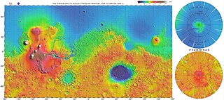
The most conspicuous feature of Mars is a sharp contrast, known as the Martian dichotomy, between the Southern and the Northern hemispheres. The two hemispheres' geography differ in elevation by 1 to 3 km. The average thickness of the Martian crust is 45 km, with 32 km in the northern lowlands region, and 58 km in the southern highlands.

The Mare Acidalium quadrangle is one of a series of 30 quadrangle maps of Mars used by the United States Geological Survey (USGS) Astrogeology Research Program. The quadrangle is located in the northeastern portion of Mars’ western hemisphere and covers 300° to 360° east longitude and 30° to 65° north latitude. The quadrangle uses a Lambert conformal conic projection at a nominal scale of 1:5,000,000 (1:5M). The Mare Acidalium quadrangle is also referred to as MC-4.

The Eridania quadrangle is one of a series of 30 quadrangle maps of Mars used by the United States Geological Survey (USGS) Astrogeology Research Program. The Eridania quadrangle is also referred to as MC-29.

The Argyre quadrangle is one of a series of 30 quadrangle maps of Mars used by the United States Geological Survey (USGS) Astrogeology Research Program. The Argyre quadrangle is also referred to as MC-26. It contains Argyre Planitia and part of Noachis Terra.
In planetary geology, a pedestal crater is a crater with its ejecta sitting above the surrounding terrain and thereby forming a raised platform. They form when an impact crater ejects material which forms an erosion-resistant layer, thus causing the immediate area to erode more slowly than the rest of the region. Some pedestals have been accurately measured to be hundreds of meters above the surrounding area. This means that hundreds of meters of material were eroded away. The result is that both the crater and its ejecta blanket stand above the surroundings. Pedestal craters were first observed during the Mariner missions.
Lipik Crater is a crater in the Hellas quadrangle of Mars, located at 38.42° S and 248.43° W. It is 56 km in diameter and was named after Lipik, a town in Croatia. Close-up pictures of the crater show glacial features. The crater is not very deep, so much ice and dust may have accumulated over the years. If one measures the diameter of a crater, the original depth can be estimated with various ratios. Because of this relationship, researchers have found that many Martian craters contain a great deal of material; much of it is believed to be ice deposited when the climate was different.

Tawhaki Patera is an active volcano on Jupiter's moon Io. It is located on Io's leading hemisphere at 3.32°N 76.18°W within the equatorial plains of western Media Regio. Tawhaki is an Ionian patera, a type of volcanic crater similar to a caldera, 49.8 kilometers (30.9 mi) wide and 550 meters (1,800 ft) deep.

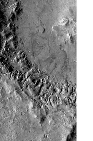
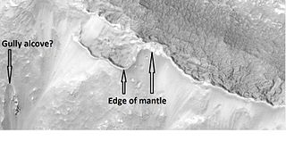
Glaciers, loosely defined as patches of currently or recently flowing ice, are thought to be present across large but restricted areas of the modern Martian surface, and are inferred to have been more widely distributed at times in the past. Lobate convex features on the surface known as viscous flow features and lobate debris aprons, which show the characteristics of non-Newtonian flow, are now almost unanimously regarded as true glaciers.
Polygonal, patterned ground is quite common in some regions of Mars. It is commonly believed to be caused by the sublimation of ice from the ground. Sublimation is the direct change of solid ice to a gas. This is similar to what happens to dry ice on the Earth. Places on Mars that display polygonal ground may indicate where future colonists can find water ice. Low center polygons have been proposed as a marker for ground ice.

Aonia Terra is a region in the southern hemisphere of the planet Mars. It is named after a classical albedo feature Aonia, that was named after the ancient Greek region Aonia.
References
- ↑ "International Journal of Thermophysics". Springer. Retrieved 2022-12-13.
- ↑ Wechsler & Glaser (1965).
- 1 2 Neugebauer et al. (1971).
- 1 2 Kieffer et al. (1973).
- 1 2 Kieffer et al. (1977).
- ↑ Wesselink (1948).
- ↑ Jaeger (1953).
- ↑ Leovy (1966).
- ↑ Haberle & Jakosky (1991).
- ↑ Hayashi et al. (1995).
- ↑ Jakosky et al. (2000).
- ↑ Mellon et al. (2000).
- Haberle, R.M.; Jakosky, B.M. (1991). "Atmospheric effects on the remote determination of thermal inertia on Mars". Icarus . 90 (2): 187–204. Bibcode:1991Icar...90..187H. doi:10.1016/0019-1035(91)90100-8.
- Hayashi, J.N.; Jakosky, B.M.; Haberle, R.M. (1995). "Atmospheric effects on the mapping of Martian thermal inertia and thermally derived albedo". J. Geophys. Res. 100 (E3): 5277–5284. Bibcode:1995JGR...100.5277H. doi:10.1029/94JE02449. hdl: 2060/19940031630 .
- Jaeger, J.C. (1953). "The Surface Temperature of the Moon". Aust. J. Phys. 6: 10. Bibcode:1953AuJPh...6...10J. doi: 10.1071/PH530010 .
- Jakosky, B.M.; Mellon, M.T.; Kieffer, H.H.; Christensen, P.R.; Varnes, E.S.; Lee, S.W. (2000). "The Thermal Inertia of Mars from the Mars Global Surveyor Thermal Emission Spectrometer". J. Geophys. Res. 105 (E4): 9643–9652. Bibcode:2000JGR...105.9643J. doi: 10.1029/1999JE001088 .
- Kieffer, H.H.; Chase, S.C.; Miner, E.; Munch, G.; Neugebauer, G. (1973). "Preliminary Report on Infrared Radiometric Measurements from the Mariner 9 Spacecraft" (PDF). J. Geophys. Res. 78 (20): 4291–4312. Bibcode:1973JGR....78.4291K. doi:10.1029/JB078i020p04291.
- Kieffer, H.H.; Martin, T.Z.; Peterfreund, A.R.; Jakosky, B.M.; Miner, E.D.; Palluconi, F.D. (1977). "Thermal and Albedo Mapping of Mars During the Viking Primary Mission". J. Geophys. Res. 82 (28): 4249–4290. Bibcode:1977JGR....82.4249K. doi:10.1029/JS082i028p04249.
- Leovy, C. (1966). "Note on the thermal properties of Mars". Icarus . 5 (1–6): 1–6. Bibcode:1966Icar....5....1L. doi:10.1016/0019-1035(66)90002-9. hdl: 2060/19650016474 .
- Mellon, M.T; Jakosky, B.M.; Kieffer, H.H.; Christensen, P.R. (2000). "High Resolution Thermal Inertia Mapping from the Mars Global Surveyor Thermal Emission Spectrometer". Icarus . 148 (2): 437–455. Bibcode:2000Icar..148..437M. doi:10.1006/icar.2000.6503.
- Neugebauer, G.; Munch, G.; Kieffer, H.H.; Chase, S.C.; Miner, E. (1971). "Mariner 1969 Infrared Radiometer Results: Temperatures and Thermal Properties of the Martian Surface" (PDF). Astron. J. 76: 719. Bibcode:1971AJ.....76..719N. doi:10.1086/111189.
- Wechsler, A.E.; Glaser, P.E. (1965). "Pressure Effects on Postulated Lunar Materials". Icarus . 4 (4): 335. Bibcode:1965Icar....4..335W. doi:10.1016/0019-1035(65)90038-2.
- Wesselink, A.J. (1948). "Heat conductivity and nature of the lunar surface material". Bull. Astron. Inst. Neth. 10: 351–363. Bibcode:1948BAN....10..351W.