Karst is a topography formed from the dissolution of soluble carbonate rocks such as limestone, dolomite, and gypsum. It is characterized by features like poljes above and drainage systems with sinkholes and caves underground. It has also been documented for more weathering-resistant rocks, such as quartzite, given the right conditions. Subterranean drainage may limit surface water, with few to no rivers or lakes. In regions where the dissolved bedrock is covered or confined by one or more superimposed non-soluble rock strata, distinctive karst features may occur only at subsurface levels and can be totally missing above ground.

An aquifer is an underground layer of water-bearing, permeable rock, rock fractures, or unconsolidated materials. Groundwater from aquifers can be extracted using a water well. Water from aquifers can be sustainably harvested through the use of qanats. Aquifers vary greatly in their characteristics. The study of water flow in aquifers and the characterization of aquifers is called hydrogeology. Related terms include aquitard, which is a bed of low permeability along an aquifer, and aquiclude, which is a solid, impermeable area underlying or overlying an aquifer, the pressure of which could create a confined aquifer. The classification of aquifers is as follows: Saturated versus unsaturated; aquifers versus aquitards; confined versus unconfined; isotropic versus anisotropic; porous, karst, or fractured; transboundary aquifer.
Environmental geology, like hydrogeology, is an applied science concerned with the practical application of the principles of geology in the solving of environmental problems created by man. It is a multidisciplinary field that is closely related to engineering geology and, to a lesser extent, to environmental geography. Each of these fields involves the study of the interaction of humans with the geologic environment, including the biosphere, the lithosphere, the hydrosphere, and to some extent the atmosphere. In other words, environmental geology is the application of geological information to solve conflicts, minimizing possible adverse environmental degradation, or maximizing possible advantageous conditions resulting from the use of natural and modified environment. With an increasing world population and industrialization, the natural environment and resources are under high strain which puts them at the forefront of world issues. Environmental geology is on the rise with these issues as solutions are found by utilizing it.

In geology, a fault is a planar fracture or discontinuity in a volume of rock across which there has been significant displacement as a result of rock-mass movements. Large faults within Earth's crust result from the action of plate tectonic forces, with the largest forming the boundaries between the plates, such as the megathrust faults of subduction zones or transform faults. Energy release associated with rapid movement on active faults is the cause of most earthquakes. Faults may also displace slowly, by aseismic creep.
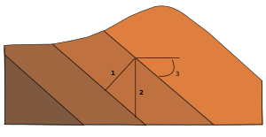
Subsidence is a general term for downward vertical movement of the Earth's surface, which can be caused by both natural processes and human activities. Subsidence involves little or no horizontal movement, which distinguishes it from slope movement.

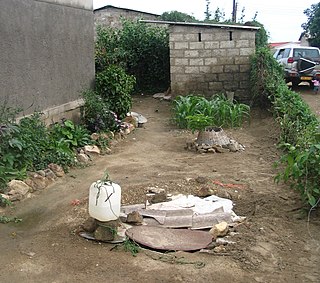
Groundwater is the water present beneath Earth's surface in rock and soil pore spaces and in the fractures of rock formations. About 30 percent of all readily available freshwater in the world is groundwater. A unit of rock or an unconsolidated deposit is called an aquifer when it can yield a usable quantity of water. The depth at which soil pore spaces or fractures and voids in rock become completely saturated with water is called the water table. Groundwater is recharged from the surface; it may discharge from the surface naturally at springs and seeps, and can form oases or wetlands. Groundwater is also often withdrawn for agricultural, municipal, and industrial use by constructing and operating extraction wells. The study of the distribution and movement of groundwater is hydrogeology, also called groundwater hydrology.

Hydrogeology is the area of geology that deals with the distribution and movement of groundwater in the soil and rocks of the Earth's crust. The terms groundwater hydrology, geohydrology, and hydrogeology are often used interchangeably.

Greensand or green sand is a sand or sandstone which has a greenish color. This term is specifically applied to shallow marine sediment that contains noticeable quantities of rounded greenish grains. These grains are called glauconies and consist of a mixture of mixed-layer clay minerals, such as smectite and glauconite. Greensand is also loosely applied to any glauconitic sediment.

A coal-seam fire is a burning of an outcrop or underground coal seam. Most coal-seam fires exhibit smouldering combustion, particularly underground coal-seam fires, because of limited atmospheric oxygen availability. Coal-seam fire instances on Earth date back several million years. Due to thermal insulation and the avoidance of rain/snow extinguishment by the crust, underground coal-seam fires are the most persistent fires on Earth and can burn for thousands of years, like Burning Mountain in Australia. Coal-seam fires can be ignited by self-heating of low-temperature oxidation, lightning, wildfires and even arson. Coal-seam fires have been slowly shaping the lithosphere and changing atmosphere, but this pace has become faster and more extensive in modern times, triggered by mining.
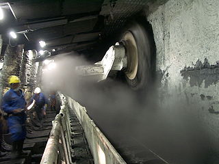
Longwall mining is a form of underground coal mining where a long wall of coal is mined in a single slice. The section of rock that is being mined, known as the longwall panel, is typically 3–4 km (1.9–2.5 mi) long, but can be up to 7.5 km (4.7 mi) long and 250–400 m (820–1,310 ft) wide.

In geology, a bed is a layer of sediment, sedimentary rock, or volcanic rock "bounded above and below by more or less well-defined bedding surfaces". Specifically in sedimentology, a bed can be defined in one of two major ways. First, Campbell and Reineck and Singh use the term bed to refer to a thickness-independent layer comprising a coherent layer of sedimentary rock, sediment, or pyroclastic material bounded above and below by surfaces known as bedding planes. By this definition of bed, laminae are small beds that constitute the smallest (visible) layers of a hierarchical succession and often, but not always, internally comprise a bed.
Groundwater models are computer models of groundwater flow systems, and are used by hydrologists and hydrogeologists. Groundwater models are used to simulate and predict aquifer conditions.
The sliding criterion (discontinuity) is a tool to estimate easily the shear strength properties of a discontinuity in a rock mass based on visual and tactile characterization of the discontinuity. The shear strength of a discontinuity is important in, for example, tunnel, foundation, or slope engineering, but also stability of natural slopes is often governed by the shear strength along discontinuities.

A Rösche is a German mining term that refers inter alia to a gullet (Wasserseige), a trench for draining water in the lower part of a mine gallery. In order to keep the actual gallery entrance (Stollenmundloch) free and guard against backflooding the Röschen were, in many cases, extended to below the entrance or led even further away, underground, to the nearest stream or river.
In German-speaking countries, the miner's toolset is known as a Gezähe formerly also abbreviated to Gezäh. It is a set of personally-owned mining tools and equipment needed by the miner in his daily work.

The Bergregal was the historic right of ownership of untapped mineral resources in parts of German-speaking Europe; ownership of the Bergregal meant entitlement to the rights and royalties from mining. Historically, it was one of those privileges that constituted the original sovereign rights of the king.

A hewer is a miner who loosens rock and minerals in a mine. In medieval mining in Europe a Hauer was the name given to a miner who had passed his test (Hauerprüfung) as a hewer.
A Pinge or Binge ("binger") is the name given in German-speaking Europe to a wedge-, ditch- or funnel-shaped depression in the terrain caused by mining activity. This depression or sink-hole is frequently caused by the collapse of old underground mine workings that are close to the Earth's surface. Unlike natural landforms, a Pinge is a direct result of human activity. The term has no direct equivalent in English, but may be translated as "mining sink-hole", "mine slump" or, in some cases, as "glory hole".
Groundwater pollution occurs when pollutants are released to the ground and make their way into groundwater. This type of water pollution can also occur naturally due to the presence of a minor and unwanted constituent, contaminant, or impurity in the groundwater, in which case it is more likely referred to as contamination rather than pollution. Groundwater pollution can occur from on-site sanitation systems, landfill leachate, effluent from wastewater treatment plants, leaking sewers, petrol filling stations, hydraulic fracturing (fracking) or from over application of fertilizers in agriculture. Pollution can also occur from naturally occurring contaminants, such as arsenic or fluoride. Using polluted groundwater causes hazards to public health through poisoning or the spread of disease.

The geology of Rhode Island is based on nearly one billion year old igneous crystalline basement rocks formed as part of the microcontinent Avalonia that collided with the supercontinent Gondwana. The region experienced substantial folding associated with its landlocked position during the Alleghanian orogeny mountain building event. The region accumulated sedimentary rocks, including small deposits of coal. The region was covered with thick Atlantic Coastal Plain sediments, with the erosion of the Appalachians and the creation of the Atlantic Ocean throughout the past 200 million years. These surficial sediments and soils were substantially reworked by the Pleistocene glaciations. The state's geology is part of the broader geology of New England.