
Route 35 is a state highway in the U.S. state of New Jersey, primarily traveling through the easternmost parts of Middlesex, Monmouth, and Ocean counties. It runs 58.1 mi (93.5 km) from the entrance to Island Beach State Park in Berkeley Township, Ocean County, to an intersection with Lincoln Highway/St. Georges Avenue (Route 27) in Rahway, Union County. Between Seaside Park and Mantoloking, Route 35 follows the right-of-way of the former Pennsylvania Railroad along the Jersey Shore. The route heads through Point Pleasant Beach and crosses the Manasquan River on the Brielle Bridge, meeting the intersection of Route 34 and Route 70 at the former Brielle Circle in Wall Township. From there, Route 35 heads north and interchanges with Route 138, an extension of I-195, continuing north through Monmouth County before crossing the Victory Bridge over the Raritan River into Perth Amboy, where the route continues north to Rahway.

Ocean County is a county located in the U.S. state of New Jersey and the southernmost county in the New York metropolitan area. The county borders the Atlantic Ocean on the east and in terms of total area is the state's largest county. Its county seat is Toms River. The county is part of the Jersey Shore and is considered part of the Central Jersey region of the state, though it was not among the four counties explicitly listed as included in Central Jersey as part of legislation signed into law in 2023.

Route 13 is a short state highway in the communities of Point Pleasant and Bay Head, New Jersey, both of which are in Ocean County. The route consists of the Lovelandtown Bridge, a vertical-lift bridge over the Point Pleasant Canal, and a part of Bridge Avenue, which is mostly maintained by the county as County Route 632 (CR 632). The route was unsigned until new mileposts were installed in 2017. Route 13 was designated in the 1953 New Jersey state highway renumbering as a re-designation of Route 13E from Hollywood Boulevard to Bay Avenue.

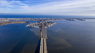
Route 37 is a state highway located in Ocean County, New Jersey, United States. The route runs 13.4 mi (21.57 km) from a traffic circle with Route 70 in Lakehurst east to an interchange with Route 35 in Seaside Heights. A two– to six–lane divided highway its entire length, Route 37 serves as the major east–west route through the Toms River area as well as a main route to the Barnegat Peninsula, crossing the Barnegat Bay on the Thomas A. Mathis and J. Stanley Tunney Bridges. The route through Toms River is lined with many businesses and named Little League World Champions Boulevard in honor of Toms River East Little League's victory in the 1998 Little League World Series. Route 37 intersects many major roads in the Toms River area, including CR 527, the Garden State Parkway/US 9, Route 166, CR 549, and CR 571. The route experiences congestion from both development in the area and from traffic bound for the barrier islands in the summer.

Beach Haven is a borough situated on the Jersey Shore in southern Ocean County, in the U.S. state of New Jersey. The borough is located on Long Beach Island (LBI) and borders the Atlantic Ocean. As of the 2020 United States census, the borough's population was 1,027, a decrease of 143 (−12.2%) from the 2010 census count of 1,170, which in turn reflected a decline of 108 (−8.5%) from the 1,278 counted in the 2000 census.

Island Heights is a borough in Ocean County, in the U.S. state of New Jersey. As of the 2020 United States census, the borough's population was 1,650, a decrease of 23 (−1.4%) from the 2010 census count of 1,673, which in turn reflected a decline of 78 (−4.5%) from the 1,751 counted in the 2000 census.

Mantoloking is a coastal borough in Ocean County, in the U.S. state of New Jersey. As of the 2020 United States census, the borough's population was 331, an increase of 35 (+11.8%) from the 2010 census count of 296, which in turn reflected a decline of 127 (−30.0%) from the 423 counted in the 2000 census. The borough has an estimated summer population of approximately 5,000.

Seaside Heights is a borough situated on the Jersey Shore, within Ocean County, in the U.S. state of New Jersey. As of the 2020 United States census, the borough's population was 2,440, a decrease of 447 (−15.5%) from the 2010 census count of 2,887, which in turn had reflected a decline of 268 (−8.5%) from the 3,155 counted in the 2000 census. Seaside Heights is located on the Barnegat Peninsula, a long, narrow barrier peninsula that separates the Barnegat Bay from the Atlantic Ocean. During the summer, the borough attracts a crowd largely under the age of 21, drawn to a community with boardwalk entertainment and one of the few shore communities with sizable numbers of apartments, attracting as many as 65,000 people who are often out until early morning visiting bars and restaurants.

Route 72 is a state highway in the U.S. state of New Jersey. It runs 28.74 mi (46.25 km) from the Four Mile Circle with Route 70 in Woodland Township in Burlington County to County Route 607 in Ship Bottom on Long Beach Island in Ocean County. Route 72 travels through the Pine Barrens as a two-lane undivided road. After an interchange with the Garden State Parkway, the route becomes a four- to six-lane divided highway through built-up areas of Manhawkin and crosses the Manahawkin Bay via the Manahawkin Bay Bridge onto Long Beach Island.

The Garden State Parkway (GSP) is a controlled-access, tolled highway that stretches the north–south length of eastern New Jersey from the state's southernmost tip near Cape May north to the New York state line at Montvale. Its name refers to New Jersey's nickname, the "Garden State". The parkway has an unsigned reference number of Route 444 by the New Jersey Department of Transportation (NJDOT). At its north end, the road becomes the Garden State Parkway Connector, a component of the New York State Thruway system that connects to the Thruway mainline in Ramapo.
The Jersey Shore, commonly referred to locally as simply the Shore, is the coastal region of the U.S. state of New Jersey. Geographically, the term encompasses about 141 miles (227 km) of oceanfront bordering the Atlantic Ocean, from Perth Amboy in the north to Cape May Point in the south. The region includes Middlesex, Monmouth, Ocean, Atlantic, and Cape May counties, which are in the central and southern parts of the state. Located in the center of the Northeast Megalopolis, the northern half of the shore region is part of the New York metro area, while the southern half of the shore region is part of the Philadelphia metro area. The Jersey Shore hosts the highest concentration of oceanside boardwalks in the United States.

Barnegat Bay is a small brackish arm of the Atlantic Ocean, approximately 42 miles (68 km) long, along the coast of Ocean County, New Jersey in the United States. It is separated from the Atlantic by the long Island Beach State Park, as well as by the north end of Long Beach Island, popular segments of the Jersey Shore. The bay is fed by several small rivers, including the Toms River, the Forked River, the Metedeconk River, Cedar Creek, Oyster Creek, Mill Creek, Westecunk Creek, and Tuckerton Creek, all of which empty into the bay through small estuaries along its inner shore. The communities of Toms River, Silverton, and Forked River sit along the river estuaries on the bay.

Long Beach Island is a barrier island and summer colony along the Atlantic Ocean coast of Ocean County, New Jersey, United States, on the Jersey Shore. Aligned north to south, the northern portion generally has more expensive low-density housing, whereas the southern portion possesses higher-density housing and considerable commercial development. Long Beach Island is 1-2 miles away from Mainland New Jersey. The primary industries include tourism, fishing, and real estate. The only access point to the island by land is a single causeway. The island is the southernmost point of the New York Metropolitan Area.

U.S. Route 9 (US 9) is a U.S. Highway in the Mid-Atlantic region of the United States, running from Laurel, Delaware, to Champlain, New York. In New Jersey, the route runs 166.80 miles (268.44 km) from the Cape May–Lewes Ferry terminal in North Cape May, Cape May County, where the ferry carries US 9 across the Delaware Bay to Lewes, Delaware, north to the George Washington Bridge in Fort Lee, Bergen County, where the route along with Interstate 95 (I-95) and US 1 continue into New York City. US 9 is the longest U.S. Highway in the state.
The Barnegat Peninsula, also known as the Island Beach Peninsula or Barnegat Bay Island and colloquially as "the barrier island", is a 20-mile (32 km) long, narrow barrier peninsula located on the Jersey Shore in Ocean County, New Jersey, United States, that divides the Barnegat Bay from the Atlantic Ocean. It is a vacation destination and summer colony area and is heavily dependent on tourism, real estate and fishing.

The Point Pleasant Canal is a canal in Point Pleasant, New Jersey. It was completed in 1925 to connect the Manasquan Inlet and Manasquan River with Bay Head Harbor on the northern end of Barnegat Bay. The canal is part of the Intracoastal Waterway.
Pelican Island is an island in the Barnegat Bay wholly located in Ocean County, New Jersey. It is accessible from Toms River and Seaside Heights via the Tunney and Mathis Bridges on New Jersey Route 37. It is part of Toms River and Berkeley Township.

Bay Head is a railway station in Bay Head, in Ocean County, New Jersey, United States. The station is served by trains on NJ Transit's North Jersey Coast Line, and it is the southern terminus for the line. The rail yard contains 33 acres (13 ha) of wetland inside the loop formed by the tracks used to turn around the trains. The rail yard borders Twilight Lake. Parking is free at the Bay Head station although the lot is only about a fourth of the size of the lot at the next station, Point Pleasant Beach, which requires payment.

Toms River is a township located on the Jersey Shore in Ocean County, in the U.S. state of New Jersey. Its mainland portion is also a census-designated place of the same name, which serves as the county seat of Ocean County. Formerly known as the Township of Dover, voters in a 2006 referendum approved a change of the official name to the Township of Toms River, adopting the name of the largest unincorporated community within the township. The township is a bedroom suburb of New York City in the New York metropolitan area, and a regional commercial hub in central New Jersey.

The Cedar Bridge Tavern is a historic building located in the New Jersey Pine Barrens in Barnegat Township. It was built around 1740 and is believed to be the oldest intact bar in the United States. It is located at the site of the last skirmish of the American Revolutionary War. It is on the National Register of Historic Places.

