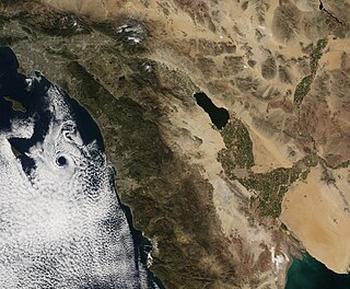
Southern California is a geographic and cultural region that generally comprises the southern portion of the U.S. state of California. It includes the Los Angeles metropolitan area, the second most populous urban agglomeration in the United States. The region generally contains ten of California's 58 counties: Imperial, Kern, Los Angeles, Orange, Riverside, San Bernardino, San Diego, Santa Barbara, San Luis Obispo and Ventura counties.

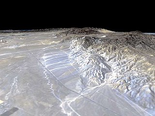
The San Andreas Fault is a continental transform fault that extends roughly 1,200 kilometers (750 mi) through California. It forms the tectonic boundary between the Pacific Plate and the North American Plate, and its motion is right-lateral strike-slip (horizontal). The fault divides into three segments, each with different characteristics and a different degree of earthquake risk. The slip rate along the fault ranges from 20 to 35 mm /yr. It was formed by a transform boundary.

The Southern California Earthquake Center (SCEC) is a collaboration of more than 1,000 scientists across 100 research institutions with a mission to: conduct research on earthquakes in Southern California and elsewhere by gathering data, conducting theoretical studies, and performing computer simulations; integrate information into a comprehensive, physics-based understanding of earthquake phenomena; and communicate that understanding to end-users and society at large as useful knowledge for reducing earthquake risk and improving community resilience..
Louis George Henyey was an American astronomer.

The 1857 Fort Tejon earthquake occurred at about 8:20 a.m. on January 9 in central and Southern California. One of the largest recorded earthquakes in the United States, with an estimated moment magnitude of 7.9, it ruptured the southern part of the San Andreas Fault for a length of about 225 miles, between Parkfield and Wrightwood.
The Garlock Fault is a left-lateral strike-slip fault running northeast–southwest along the north margins of the Mojave Desert of Southern California, for much of its length along the southern base of the Tehachapi Mountains.
The 1999 Hector Mine earthquake occurred in Southern California, United States, on October 16 at 02:46:50 PDT. Its moment magnitude was 7.1 and the earthquake was preceded by 12 foreshocks, the largest of which had a magnitude of 3.8. The Hector Mine earthquake is also thought to have been triggered by the 1992 Landers Earthquake that occurred seven years prior. The earthquake caused minimal damage due to the distance of its epicenter from any population centers. It also deformed nearby faults vertically and horizontally. The earthquake's hypocenter was at a depth of 20 kilometers and its epicenter at 34.603° N 116.265° W. Due to the time and place at which the earthquake occurred, there was little damage to the surrounding area as well as zero deaths. The significance of this earthquake lies in the fact that, firstly, it had a relatively-high magnitude but caused little damage and secondly, it offered more evidence that stress accumulation over time causes earthquakes.

The Newport–Inglewood Fault is a right-lateral strike-slip fault in Southern California. The fault extends for 47 mi (76 km) from Culver City southeast through Inglewood and other coastal communities to Newport Beach at which point the fault extends east-southeast into the Pacific Ocean where it is known as the Rose Canyon Fault. The fault can be inferred on the Earth's surface as passing along and through a line of hills extending from Signal Hill to Culver City. The fault has a slip rate of approximately 0.6 mm (0.024 in)/year and is predicted to be capable of a 6.0–7.4 magnitude earthquake on the moment magnitude scale. A 2017 study concluded that, together, the Newport–Inglewood Fault and Rose Canyon Fault could produce an earthquake of 7.3 or 7.4 magnitude.

The Elsinore Fault Zone is a large right-lateral strike-slip geological fault structure in Southern California. The fault is part of the trilateral split of the San Andreas fault system and is one of the largest, though quietest faults in Southern California.
1365 Henyey, provisional designation 1928 RK, is a stony Florian asteroid from the inner regions of the asteroid belt, approximately 11 kilometers in diameter. It was discovered by German astronomer Max Wolf at Heidelberg Observatory in southern Germany on 9 September 1928, and named for American astronomer Louis Henyey.

The 1992 Landers earthquake occurred on Sunday, June 28 with an epicenter near the town of Landers, California, in San Bernardino County. The shock had a moment magnitude of 7.3 and a maximum Mercalli intensity of IX (Violent).

The Chinese Historical Society of America is the oldest and largest archive and history center documenting the Chinese American experience in the United States. It is based in the Chinatown neighborhood of San Francisco, California.

The San Jacinto Fault Zone (SJFZ) is a major strike-slip fault zone that runs through San Bernardino, Riverside, San Diego, and Imperial Counties in Southern California. The SJFZ is a component of the larger San Andreas transform system and is considered to be the most seismically active fault zone in the area. Together they relieve the majority of the stress between the Pacific and North American tectonic plates.
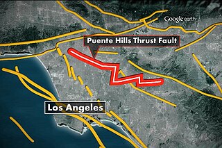
The Puente Hills Fault is an active geological fault that is located in the Los Angeles Basin in California. The thrust fault was discovered in 1999 and runs about 40 km (25 mi) in three discrete sections from the Puente Hills region in the southeast to just south of Griffith Park in the northwest. The fault is known as a blind thrust fault, as the fault plane does not extend to the surface. Large earthquakes on the fault are relatively infrequent but computer modeling has indicated that a major event could have substantial impact in the Los Angeles area. The fault is now thought to be responsible for one moderate earthquake in 1987 and another light event that took place in 2010, with the former causing considerable damage and deaths.

The Imperial Fault Zone is a system of geological faults located in Imperial County in the Southern California region, and adjacent Baja California state in Mexico. It cuts across the border between the United States and Mexico.
The Brawley Seismic Zone (BSZ), also known as the Brawley fault zone, is a predominantly extensional tectonic zone that connects the southern terminus of the San Andreas Fault with the Imperial Fault in Southern California. The BSZ is named for the nearby town of Brawley in Imperial County, California, and the seismicity there is characterized by earthquake swarms.
The 1940 El Centro earthquake occurred at 21:35 Pacific Standard Time on May 18 in the Imperial Valley in southeastern Southern California near the international border of the United States and Mexico. It had a moment magnitude of 6.9 and a maximum perceived intensity of X (Extreme) on the Mercalli intensity scale. It was the first major earthquake to be recorded by a strong-motion seismograph located next to a fault rupture. The earthquake was characterized as a typical moderate-sized destructive event with a complex energy release signature. It was the strongest recorded earthquake to hit the Imperial Valley, and caused widespread damage to irrigation systems and led to the deaths of nine people.

The 1892 Laguna Salada earthquake occurred at . It had an estimated moment magnitude of 7.1–7.2 and a maximum perceived intensity of VIII (Severe). The shock was centered near the Mexico–United States border and takes its name from a large dry lake bed in Baja California, Mexico. There were no reported casualties, but the event affected the then largely-uninhabited areas of northern Mexico and Southern California.

The 1812 Ventura earthquake occurred on the morning of December 21 at UTC 19:00 or 10:00 Pacific Standard Time (PST), on Monday. The 7.1–7.5 magnitude earthquake, with a Mercalli intensity scale rating of VIII (Severe), along with its resulting tsunami, caused considerable damage to present-day Santa Barbara and Ventura County, California, which was at the time a territory of the Spanish Empire. One person was killed as a result of the earthquake while another from the aftershock. The earthquake occurred just as the region was recovering from another event on the 8th of December the same year. Both events are thought to have been related.