Southern California Earthquake Center

Last updated
Southern California
Earthquake Center
Formation1991
Headquarters Los Angeles, California
Membership
18 Core Institutions and 75 Participating Institutions
Director
Yehuda Ben-Zion
Co-Director
Gregory C. Beroza
Website www.scec.org

The Southern California Earthquake Center (SCEC) is a collaboration of more than 1,000 scientists across 100 research institutions with a mission to: conduct research on earthquakes in Southern California and elsewhere by gathering data, conducting theoretical studies, and performing computer simulations; integrate information into a comprehensive, physics-based understanding of earthquake phenomena; and communicate that understanding to end-users and society at large as useful knowledge for reducing earthquake risk and improving community resilience..

Contents

SCEC headquarters are at the University of Southern California. SCEC partners with many other research and education/outreach organizations in many disciplines. Primary funding for SCEC activities is provided by the National Science Foundation and the United States Geological Survey. The current director of SCEC is Yehuda Ben-Zion.

The Southern California Earthquake Center (SCEC) was founded as a Science & Technology Center on February 1, 1991, with joint funding by the National Science Foundation (NSF) and the U. S. Geological Survey (USGS). SCEC graduated from the STC Program in 2002 and has been funded as a stand-alone center under cooperative agreements with both agencies in four consecutive phases: SCEC2, 1 Feb 2002 to 31 Jan 2007; SCEC3, 1 Feb 2007 to 31 Jan 2012; SCEC4, 1 Feb 2012 to 31 Jan 2017; and SCEC5, 1 Feb 2017 to 31 Jan 2022.

Headquarters

SCEC Headquarters are located at the University of Southern California's University Park campus just south of Downtown Los Angeles. Administrative offices for SCEC are located on the first floor of the Zumberge Hall of Science (ZHS) on Trousdale Parkway. Other facilities in Zumberge Hall include an outreach and education office, software development and research computing office, undergraduate computer lab, office of director Yehuda Ben-Zion as well as several meeting rooms.

Research

SCEC coordinates fundamental research on earthquake processes using Southern California as its main natural laboratory. Currently, over 1,000 earthquake professionals are participating in SCEC projects. SCEC’s long-range science vision is to develop dynamical models of earthquake processes that are comprehensive, integrative, verified, predictive, and validated against observations. The science goal of the SCEC core program is to provide new concepts that can improve the predictability of the earthquake system models, new data for testing the models, and a better understanding of model uncertainties. SCEC is one of three institutions (the other being the California Geological Survey and USGS) that form the Working Group on California Earthquake Probabilities (WGCEP), responsible for creating the California earthquake "forecast," UCERF. The current version, with the latest forecast results, is known as UCERF3. [1]

Core institutions

SCEC Headquarters in Zumberge Hall Scec headquarters.jpg
SCEC Headquarters in Zumberge Hall

Core institutions involved in SCEC research include but are not limited to:

Education and Outreach programs

Great ShakeOut Earthquake Drills

Since 2008, SCEC has coordinated Great ShakeOut Earthquake ShakeOut Drills, a worldwide earthquake safety movement. [2]

Internships: UseIT and SURE

SCEC currently operates two different internship programs funded in part by the National Science Foundation and the United States Department of Defense as well as several other institutions including the University of Southern California and the United States Geological Survey. These two programs are the UseIT program which is directed towards developing software for understanding earthquakes worldwide and the SURE program which is aimed at more focused topics of research in the Earth Sciences. The director of these two programs is Dr. Gabriela Noriega. [3]

The SCEC UseIT (Undergraduate Studies in Earthquake Information Technology) program, unites undergraduates who are sophomores, juniors, or seniors in the coming fall, taking potentially any major, and coming from colleges and universities across the continent to participate in a leading-edge program at SCEC headquarters.

SCEC/UseIT interns work on multi-disciplinary, collaborative teams to tackle a scientific "Grand Challenge" posed by 2002–2017 SCEC director Dr. Thomas H. Jordan. The Grand Challenge varies each year but always entails performing computer science research that is needed by earthquake scientists or outreach professionals. [4]

The SCEC SURE (Summer Undergraduate Research Experience) program pairs a student, one-on-one, to conduct research with a pre-eminent earthquake scientist or specialist. Many SURE interns also have the opportunity to work alongside graduate students and post-doctoral researchers, and thus gain the special perspective of these early career professionals.

Started in 1994, SCEC/SURE has supported students to work in a very wide variety of fields related to earthquake science, including paleoseismic field investigations, remote sensing, risk mitigation, seismic velocity modeling, effects of earthquakes on natural resources such as groundwater, science education, information technology, and earthquake engineering. [5]

Earthquake Country Alliance

The Earthquake Country Alliance is administered by SCEC and organizes many earthquake preparedness and mitigation activities around California, such as regional workshops, the Great California ShakeOut Earthquake Drill, and an microgrants program called the "ECA Mini-Awards." The website, [6] features many resources for the public. The Earthquake Country Alliance (ECA) is described by itself as a public-private-grassroots partnership of people, organizations, and regional alliances that work together to improve earthquake and tsunami preparedness, mitigation and resiliency.

See also

Related Research Articles

<span class="mw-page-title-main">IRIS Consortium</span>

IRIS is a university research consortium dedicated to exploring the Earth's interior through the collection and distribution of seismographic data. IRIS programs contribute to scholarly research, education, earthquake hazard mitigation, and the verification of a Comprehensive Nuclear-Test-Ban Treaty. Support for IRIS comes from the National Science Foundation, other federal agencies, universities, and private foundations. IRIS supports five major components, the Data Management Center (DMC), the Portable Array Seismic Studies of the Continental Lithosphere (PASSCAL), the Global Seismographic Network (GSN), the Transportable Array (USARRAY), and the Education and Public Outreach Program (EPO). IRIS maintains a Corporate Office in Washington, DC.

<span class="mw-page-title-main">Earthscope</span> Earth science program exploring the structure of the North American continent

The EarthScope project was an National Science Foundation (NSF) funded earth science program that, from 2003-2018, used geological and geophysical techniques to explore the structure and evolution of the North American continent and to understand the processes controlling earthquakes and volcanoes. The project had three components: USArray, the Plate Boundary Observatory, and the San Andreas Fault Observatory at Depth. Organizations associated with the project included UNAVCO, the Incorporated Research Institutions for Seismology (IRIS), Stanford University, the United States Geological Survey (USGS) and National Aeronautics and Space Administration (NASA). Several international organizations also contributed to the initiative. EarthScope data are publicly accessible.

<span class="mw-page-title-main">China Geological Survey</span>

The China Geological Survey (CGS) (Chinese: 中国地质调查局) is a government-owned, not-for-profit, Chinese organization researching China's mineral resources. It is a public institution managed by the State Council's ministries and commissions responsible for geological and mineral exploration under the State Council of the People's Republic of China. According to the national land and resources survey plan, it is now managed by the Ministry of Natural Resources. It is the largest Geoscience agency in China since being reinstated in 1999, and the headquarter is in Beijing, the capital of China.

The Jackson School of Geosciences at The University of Texas at Austin unites the Department of Geological Sciences with two research units, the Institute for Geophysics and the Bureau of Economic Geology.

Earthquake forecasting is a branch of the science of seismology concerned with the probabilistic assessment of general earthquake seismic hazard, including the frequency and magnitude of damaging earthquakes in a given area over years or decades. While forecasting is usually considered to be a type of prediction, earthquake forecasting is often differentiated from earthquake prediction, whose goal is the specification of the time, location, and magnitude of future earthquakes with sufficient precision that a warning can be issued. Both forecasting and prediction of earthquakes are distinguished from earthquake warning systems, which, upon detection of an earthquake, provide a real-time warning to regions that might be affected.

QuakeSim is a NASA project for modeling earthquake fault systems. It was started in 2001 with NASA funding as a follow-up to the General Earthquake Models (GEM) initiative. The multi-scale nature of earthquakes requires integrating data types and models to fully simulate and understand the earthquake process. QuakeSim is a computational framework for modeling and understanding earthquake and tectonic processes.

<span class="mw-page-title-main">Lucy Jones</span> American seismologist

Lucile M. Jones is a seismologist and public voice for earthquake science and earthquake safety in California. One of the foremost and trusted public authorities on earthquakes, Jones is viewed by many in Southern California as the "seismologist-next-door," who is frequently called up on to provide information on recent earthquakes.

The University of California, Irvine has over fourteen academic divisions.

Computational geophysics is the field of study that uses any type of numerical computations to generate and analyze models of complex geophysical systems. It can be considered an extension, or sub-field, of both computational physics and geophysics. In recent years, computational power, data availability, and modelling capabilities have all improved exponentially, making computational geophysics a more populated discipline. Due to the large computational size of many geophysical problems, high-performance computing can be required to handle analysis. Modeling applications of computational geophysics include atmospheric modelling, oceanic modelling, general circulation models, and geological modelling. In addition to modelling, some problems in remote sensing fall within the scope of computational geophysics such as tomography, inverse problems, and 3D reconstruction.

The Center for Microbial Oceanography (C-MORE) is a research and education organization established in 2006 as a National Science Foundation funded Science and Technology Center.

Avetec is a non-profit research organization located in Springfield, Ohio. Avetec is currently conducting modeling and simulation research that aims to reduce the cost and time it takes to design, develop and test new jet turbine engines for commerce and the military.

<span class="mw-page-title-main">United States Geological Survey</span> Scientific agency of the United States government

The United States Geological Survey (USGS), founded as the Geological Survey, is an agency of the United States government whose work spans the disciplines of biology, geography, geology, and hydrology. The agency was founded on March 3, 1879, to study the landscape of the United States, its natural resources, and the natural hazards that threaten it. The agency also makes maps of extraterrestrial planets and moons based on data from U.S. space probes.

UNAVCO is a non-profit university-governed consortium that facilitates geology research and education using geodesy.

Ross Stein is a scientist emeritus at the U.S. Geological Survey in Menlo Park, California. Stein is also cofounder and CEO of Temblor, a startup enabling people to learn their seismic hazard and determine steps to reduce their risk.

<span class="mw-page-title-main">Southern California faults</span>

Most of central and northern California rests on a crustal block (terrane) that is being torn from the North American continent by the passing Pacific plate of oceanic crust. Southern California lies at the southern end of this block, where the Southern California faults create a complex and even chaotic landscape of seismic activity.

<span class="mw-page-title-main">UCERF2</span>

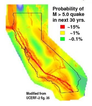
The 2008 Uniform California Earthquake Rupture Forecast, Version 2, or UCERF2, is one of a series of earthquake forecasts prepared for the state California by the Working Group on California Earthquake Probabilities (WGCEP), collaboration of the U.S. Geological Survey, the California Geological Survey, and the Southern California Earthquake Center, with funding from the California Earthquake Authority. UCERF2 was superseded by UCERF3 in 2015.

<span class="mw-page-title-main">UCERF3</span> 2015 US Geological Survey earthquake forecast for California

The 2015 Uniform California Earthquake Rupture Forecast, Version 3, or UCERF3, is the latest official earthquake rupture forecast (ERF) for the state of California, superseding UCERF2. It provides authoritative estimates of the likelihood and severity of potentially damaging earthquake ruptures in the long- and near-term. Combining this with ground motion models produces estimates of the severity of ground shaking that can be expected during a given period, and of the threat to the built environment. This information is used to inform engineering design and building codes, planning for disaster, and evaluating whether earthquake insurance premiums are sufficient for the prospective losses. A variety of hazard metrics can be calculated with UCERF3; a typical metric is the likelihood of a magnitude M 6.7 earthquake in the 30 years since 2014.

Joan S. Gomberg is a research geophysicist at the United States Geological Survey. She serves as an adjunct professor at the University of Washington. She is interested in subduction zone science, and studies how earthquakes trigger each other and how faults can slip. Gomberg is a Fellow of the American Geophysical Union. She was the first person to demonstrate how dynamic stress associated with seismic waves can trigger other earthquakes.

Paul Segall is a geophysicist best known for his studies on earthquake and volcanism. He is currently a professor in the department of geophysics at Stanford University. He has served in Board of Directors in Southern California Earthquake Center since 2007.

References

  1. "WGCEP | Working Group on California Earthquake Probabilities".
  2. "About SCEC | Southern California Earthquake Center". www.scec.org. Archived from the original on 16 September 2015. Retrieved 13 January 2022.
  3. http://www.scec.org/internships Archived 2011-07-09 at the Wayback Machine
  4. "SCEC Internships | Southern California Earthquake Center".
  5. "SURE Internship ABOUT Page | Southern California Earthquake Center".
  6. "Earthquake Country Alliance: Welcome to Earthquake Country!".

Sources

34°1′13″N118°17′8″W / 34.02028°N 118.28556°W / 34.02028; -118.28556