
Lidar is a method for determining ranges by targeting an object with a laser and measuring the time for the reflected light to return to the receiver. Lidar can also be used to make digital 3-D representations of areas on the earth's surface and ocean bottom, due to differences in laser return times, and by varying laser wavelengths. It has terrestrial, airborne, and mobile applications.
Remote sensing is the acquisition of information about an object or phenomenon without making physical contact with the object, in contrast to in situ or on-site observation. The term is applied especially to acquiring information about the Earth and other planets. Remote sensing is used in numerous fields, including geography, land surveying and most Earth science disciplines ; it also has military, intelligence, commercial, economic, planning, and humanitarian applications, among others.

The University of Alabama in Huntsville (UAH) is a public research university in Huntsville, Alabama. The university is accredited by the Southern Association of Colleges and Schools to award baccalaureate, master's, and doctoral degrees, and comprises nine colleges: arts, humanities & social sciences; business; education; engineering; honors; nursing; professional & continuing studies; science; and graduate. The university's enrollment is approximately 10,000. It is classified among "R2: Doctoral Universities – High research activity".

The stone spheres of Costa Rica are an assortment of over 300 petrospheres in Costa Rica, on the Diquís Delta and on Isla del Caño. Locally, they are also known as bolas de piedra. The spheres are commonly attributed to the extinct Diquís culture, and they are sometimes referred to as the Diquís Spheres. They are the best-known stone sculptures of the Isthmo-Colombian area.
Aviation archaeology is a recognized sub-discipline within archaeology and underwater archaeology as a whole. It is an activity practiced by both enthusiasts and academics in pursuit of finding, documenting, recovering, and preserving sites important in aviation history. For the most part, these sites are aircraft wrecks and crash sites, but also include structures and facilities related to aviation. It is also known in some circles and depending on the perspective of those involved as aircraft archaeology or aerospace archaeology and has also been described variously as crash hunting, underwater aircraft recovery, wreck chasing, or wreckology.

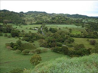
Guayabo National Monument, is an archaeological site near the city of Turrialba, within the Central Conservation Area in the Cartago Province, Costa Rica. It is almost directly in the center of the country on the Southern slope of the Turrialba Volcano. The National Monument covers about 2.3 square kilometres (0.89 sq mi) and is surrounded by rainforest plant vegetation causing it to be extremely vibrant green due to high precipitation and rich soils. Only a small portion of it has been unearthed, excavated, and studied.
Juris Zarins (Zariņš) is an American-Latvian archaeologist and professor at Missouri State University, who specializes in the Middle East.

Sarah Helen Parcak is an American archaeologist and Egyptologist, who has used satellite imaging to identify potential archaeological sites in Egypt, Rome, and elsewhere in the former Roman Empire. She is a professor of Anthropology and director of the Laboratory for Global Observation at the University of Alabama at Birmingham. In partnership with her husband, Greg Mumford, she directs survey and excavation projects in the Faiyum, Sinai, and Egypt's East Delta.
William Andrew "Bill" Saturno is an American archaeologist and Mayanist scholar who has made significant contributions toward the study of the pre-Columbian Maya civilization. As of February 2015, Saturno holds a position as assistant professor in Archaeology at Boston University's (BU's) College of Arts and Sciences (CAS). He is also the director of the Proyecto San Bartolo-Xultun at the Instito de Antropologia e Historia in Guatemala, a national space research scientist at the Marshall Space Flight Center, as well as a research associate at the Peabody Museum at Harvard University. Prior to his position at BU, Saturno was a lecturer at the University of New Hampshire.
Archaeology or archeology is the study of human activity through the recovery and analysis of material culture. The archaeological record consists of artifacts, architecture, biofacts or ecofacts, sites, and cultural landscapes. Archaeology can be considered both a social science and a branch of the humanities. In Europe it is often viewed as either a discipline in its own right or a sub-field of other disciplines, while in North America archaeology is a sub-field of anthropology.
Remote sensing techniques in archaeology are an increasingly important component of the technical and methodological tool set available in archaeological research. The use of remote sensing techniques allows archaeologists to uncover unique data that is unobtainable using traditional archaeological excavation techniques.

Holmul is a pre-Columbian archaeological site of the Maya civilization located in the northeastern Petén Basin region in Guatemala near the modern-day border with Belize.
Barriles, is one of the most famous archaeological sites in Panama. It is located in the highlands of the Chiriquí Province of Western Panama at 1200 meters above sea level. It is several kilometers west of the modern town of Volcán. This places the site in the Gran Chiriquí culture area. The site was originally named for several small stone barrels found in the area, although these have also been found elsewhere in the Río Chiriquí Viejo valley and in Costa Rica. This area has a cool, spring-like climate with a pronounced rainy season between May and November, and a dry but windy season the rest of the year. The region lies on the western flanks of Volcán Barú, a dormant volcano and the highest mountain in Panama.
Las Mercedes (L-289-LM) is a complex archaeological site located on the Caribbean slope of Costa Rica between the foothills of Turrialba Volcano and the alluvial plain. The site contains a variety of architectural features including platforms, plazas, retaining walls or terraces, funerary areas, ramps, and paved roads.
The Arenal Prehistory Project was a multidisciplinary research effort taking place between 1984 and 1987 that uncovered evidence of human occupation from Paleoindian and Archaic times through four sedentary phases to the Spanish Conquest in the tropical rainforest of Northwest Costa Rica.

Atlantis of the Sands refers to a legendary lost city in the southern deserts of the Arabian Peninsula, thought to have been destroyed by a natural disaster or as a punishment by God. The search for it was popularised by the 1992 book Atlantis of the Sands – The Search for the Lost City of Ubar by Ranulph Fiennes. Apart from English name, coined by T. E. Lawrence, the city is commonly also called Ubar, Wabar or Iram.
Diane Zaino Chase is an American anthropologist and archaeologist who specializes in the study of the Ancient Maya.
Payson D. Sheets is an American archaeologist, Mayanist, and professor of anthropology at the University of Colorado Boulder. He is primarily known for his research in Pre-Columbian Mesoamerica and Lower Central America, most importantly for his work on the Maya civilization at Joya de Cerén in El Salvador. He specializes in Mesoamerican archaeology, lithic technology, ancient adaptations, geophysical applications, hazards research, and remote sensing.

Arlen F. Chase is a Mesoamerican archaeologist and a faculty member in the anthropology department at Pomona College, Claremont CA. Previously, he was a professor at the University of Nevada, Las Vegas and served a variety of administrative roles at the University of Central Florida over the course of his 32 year stay at that institution. He is noted for his long-term research at the ancient Maya city of Caracol, Belize and for exploring landscape traces of Maya civilization using lidar.
La Ciudad Blanca is a legendary settlement said to be located in the Mosquitia region of the Gracias a Dios Department in eastern Honduras. It is also known by the Pech name Kahã Kamasa. This extensive area of rainforest, which includes the Río Plátano Biosphere Reserve, has long been the subject of multidisciplinary research. Archaeologists refer to it as being a part of the Isthmo-Colombian Area of the Americas, one in which the predominant indigenous languages included those in the Chibchan and Misumalpan families. Due to the many variants of the story in the region, most professional archaeologists doubt it refers to any one actual settlement, much less one representing a city of the Pre-Columbian era. They point out that there are multiple large archaeological sites in the region and that references to the legendary White City cannot be proven to refer to any single place.