
Welney is a village and civil parish in the Fens of England and the county of Norfolk. The village is about 10 miles (16 km) south-west of the town of Downham Market, 20 miles (30 km) south of the town of King's Lynn and 45 miles (70 km) west of the city of Norwich. The county boundary with Cambridgeshire is adjacent, with the city of Cambridge 25 miles (40 km) to the south.

Wisbech is a market town, inland port and civil parish in the Fenland district in Cambridgeshire, England. In 2011 it had a population of 31,573. The town lies in the far north-east of Cambridgeshire, bordering Norfolk and only 5 miles (8 km) south of Lincolnshire. The tidal River Nene running through the town is spanned by two road bridges. Wisbech is in the Isle of Ely and has been described as "the Capital of The Fens".

Fenland is a local government district in Cambridgeshire, England. It was historically part of the Isle of Ely. The district covers around 500 square kilometres (190 sq mi) of mostly agricultural land in the extremely flat Fens. The council is based in Fenland Hall, in March. Other towns include Chatteris, Whittlesey and Wisbech, the largest of the four.

Thorney is a village in the Peterborough unitary authority in the ceremonial county of Cambridgeshire, England. Located around eight miles (13 km) east of Peterborough city centre, on the A47.

Wisbech was a rural district in Cambridgeshire in England from 1894 to 1974.
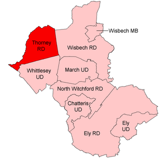
Thorney was a rural district in England from 1894 to 1974, situated to the east of Peterborough.
Wisbech Castle was a stone to motte-and-bailey castle built to fortify Wisbech on the orders of William I in 1072, it probably replaced an earlier timber and turf complex. The layout was probably oval in shape and size, on the line still marked by the Circus. The original design and layout is unknown. It was rebuilt in stone in 1087. The castle was reputedly destroyed in a flood in 1236. In the 15th century, repairs were becoming too much for the ageing structure, and a new building was started in 1478 under John Morton, Bishop of Ely. His successor, John Alcock, extended and completed the re-building and died in the Castle in 1500. Subsequent bishops also spent considerable sums on this new palace. The Bishop's Palace was built of brick with dressings of Ketton Stone, but its exact location is unknown.
Wisbech is a former United Kingdom Parliamentary constituency. It was created upon the abolition of an undivided Cambridgeshire county constituency in 1885 and was itself abolished in 1918.
Guyhirn is a village near the town of Wisbech in Cambridgeshire, England. It is on the northern bank, the North Brink, of the River Nene, at the junction of the A141 with the A47. The population is included in the civil parish of Wisbech St Mary. It is notable chiefly for the Chapel of Ease, a rare example of church architecture of the Interregnum (1649–1660), and as a key crossing point of the River Nene.

Upwell is a village and civil parish in the English county of Norfolk. Upwell village is on the A1101 road, as is Outwell, its conjoined village at the north. The nearest towns are Wisbech to the north-west and Downham Market to the east.

Wisbech St Mary is a village in the Fenland District of Cambridgeshire, England. It is 2 miles (3 km) west of the town of Wisbech. It lies between two roads, the B1169 and the A47. The population of the civil parish at the 2011 Census was 3,556.

Murrow is a village in the civil parish of Wisbech St Mary, in Cambridgeshire, England.
Newark was a hamlet of the parish of Saint Mary the Virgin in the Soke of Peterborough in the United Kingdom. One mile and a half (2.4 km) north-east-by-east from the city centre; a portion was incorporated with the municipal borough in 1874. The remainder formed part of Peterborough Rural District from 1894 until 1926 when the city's boundaries were extended to include the civil parish of Peterborough Without.

Walsoken is a settlement and civil parish in Norfolk, England, which is conjoined as a suburb at the northeast of the town of Wisbech, Isle of Ely, Cambridgeshire.
Coldham is a hamlet in Elm civil parish, part of the Fenland district of the Isle of Ely, Cambridgeshire, England. Coldham is the site of a wind farm on a large farm estate of the Cooperative Group near the settlement.
Tholomas Drove is a hamlet in Wisbech St Mary civil parish, part of the Fenland district in the Isle of Ely, Cambridgeshire, England. The population is included in the civil parish of Parson Drove. In 1989, there were 120 residents. The origins of the name are unclear but it has also been written as Tholomer's Drove and Tallamass Drove.

Newton-in-the-Isle is a village and civil parish in the Fenland District of the Isle of Ely, Cambridgeshire, England, The village is 4 miles (6 km) to the north of Wisbech.

The Parish Church of St Peter and St Paul or St Peter's Church is an Anglican church in Wisbech, Cambridgeshire, England. It is an active parish church in the Diocese of Ely. The church was founded in the 12th century.
