The South Downs Way is a long distance footpath and bridleway running along the South Downs in southern England. It is one of 16 National Trails in England and Wales. The trail runs for 160 km (100 mi) from Winchester in Hampshire to Eastbourne in East Sussex, with about 4,150 m (13,620 ft) of ascent and descent.
The Cotswold Way is a 102-mile (164 km) long-distance footpath, running along the Cotswold Edge escarpment of the Cotswold Hills in England. It was officially inaugurated as a National Trail on 24 May 2007 and several new rights of way have been created.
The Clarendon Way is a recreational footpath in Hampshire and Wiltshire, England. It starts beside the waters of the River Itchen in the centre of Winchester and ends near the River Avon at Salisbury Cathedral. The path passes through the Clarendon Estate and close to the 12th century ruins of Clarendon Palace. The path also passes through Farley Mount Country Park and the villages of Pitton, The Winterslows, Broughton and King's Somborne. The path shares part of its route with the Monarch's Way long-distance footpath.
The Itchen Way is a 31.80-mile (51.18 km) long-distance footpath following the River Itchen in Hampshire, England, from its source near Hinton Ampner House to its mouth at Woolston. The walk finishes at Sholing railway station. The route has been promoted by the Eastleigh Group of the Ramblers with grant aid from Hampshire County Council and Eastleigh Borough Council. The route was altered and improved in 2008.
King's Way or the Allan King Way is a 45-mile-long-distance (72 km) footpath in Hampshire, England. This footpath was created by the Hampshire Area of the Ramblers' Association as a memorial to the late Allan King, a former Publicity Officer who was partly responsible for the formation of a number of Groups in Hampshire. The route runs from Portchester to Winchester via Bishops Waltham and passes by sites such as Portchester Castle, Fort Nelson, and Bishops Waltham Palace
St Swithun's Way is a 34-mile (55 km) long-distance footpath in England from Winchester Cathedral, Hampshire to Farnham, Surrey. It is named after Swithun, a 9th-century Bishop of Winchester, and roughly follows the Winchester to Farnham stretch of the Pilgrims' Way. The route was opened in 2002 to mark the Golden Jubilee of Elizabeth II.
The Monarch's Way is a 625-mile (1,006 km) long-distance footpath in England that approximates the escape route taken by King Charles II in 1651 after being defeated in the Battle of Worcester. It runs from Worcester via Bristol and Yeovil to Shoreham, West Sussex.
Weardale Way is a footpath that follows the River Wear in the North East of England. It is 73 miles long, starting at the Lindesfarne Memorial on the sea wall at Roker. It then passes through Chester-le-Street, Durham, Bishop Auckland, Wolsingham and Stanhope. The path ends outside the Post Office in the village of Wearhead in County Durham.
The Thames Path is a National Trail following the River Thames from one of its sources near Kemble in Gloucestershire to the Woolwich foot tunnel, south east London. It is about 185 miles (298 km) long. A path was first proposed in 1948 but it only opened in 1996.
The Limestone Way is a waymarked long-distance footpath in Derbyshire, England. It runs for 46 miles (74 km) through the White Peak of the Peak District National Park, from Castleton south to Rocester over the county boundary into Staffordshire. The trail is named for the limestone scenery along its route. It was devised by Brian Spencer of Matlock Rotary Club and developed and opened in 1986 by the West Derbyshire District Council. It originally ran to Matlock, but was extended to its current, longer route in 1992 to join up with the Staffordshire Way.
The Staffordshire Way is a long-distance walk in Staffordshire, England. The path links with the Cheshire Gritstone Trail, the Heart of England Way and the North Worcestershire Path.
The following are lists of recreational walks in Hampshire, England:
The South Cheshire Way is a 34-mile (55 km) long-distance footpath running east–west mainly through Cheshire, England, although parts lie in Shropshire and Staffordshire. The western section from Grindley Brook, near Whitchurch, runs through farmland; the eastern section from Mow Cop, near Biddulph, runs through low hills. The footpath is waymarked with black-and-yellow discs inscribed 'SCW'. It is covered by the Ordnance Survey Explorer series 257 and 268 maps, which denote it with a green lozenge.
The Icknield Way Path or Icknield Way Trail is a long distance footpath and riding route in East Anglia, England. The ancient Icknield Way itself is unique among long-distance trails because it can claim to be ‘the oldest road in Britain’. It consists of prehistoric pathways, ancient when the Romans came; the route is dotted with archaeological remains. It survives today in splendid tracks and green lanes along the ‘chalk spine’ of southern England.
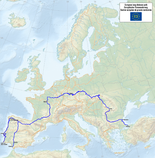
The E3 European long distance path, or just E3 path, is a 6,950-kilometre (4,320 mi) long-distance footpath that is planned to run from the Portuguese coast to the Black Sea in Bulgaria. It is one of the network of European long-distance paths.
Walking is one of the most popular outdoor recreational activities in the United Kingdom, and within England and Wales there is a comprehensive network of rights of way that permits access to the countryside. Furthermore, access to much uncultivated and unenclosed land has opened up since the enactment of the Countryside and Rights of Way Act 2000. In Scotland the ancient tradition of universal access to land was formally codified under the Land Reform (Scotland) Act 2003. In Northern Ireland, however, there are few rights of way, or other access to land.
The Dollis Valley Greenwalk is a footpath route in the London Borough of Barnet in London, England, between Moat Mount Nature Reserve in Mill Hill and Hampstead Heath. The route is designed to act as a link between the Capital Ring and the London Loop, and between the many green spaces and wildlife corridors along the way. It is approximately 10 miles (16 km) long. It mainly follows the Dollis Brook and is one of the many parks and open spaces in Barnet.
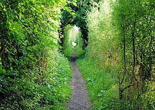
A long-distance trail is a longer recreational trail mainly through rural areas used for hiking, backpacking, cycling, horse riding or cross-country skiing. They exist on all continents except Antarctica.
The North Cheshire Way is a 71-mile (114 km) long-distance footpath in Cheshire, England. It runs approximately eastwards from Hooton railway station on the Wirral peninsula to Disley railway station on the edge of the Peak District, where it connects with the Gritstone Trail. There is a 6-mile (9.7 km) spur from Chester to Croughton.
This page is based on this Wikipedia article Text is available under the CC BY-SA 4.0 license; additional terms may apply. Images, videos and audio are available under their respective licenses.