
The Downtown Manhattan Heliport is a helicopter landing platform at Pier 6 in the East River in Lower Manhattan, New York City, New York.
Ryon Heliport is a private-use heliport located two miles north of the central business district of Pottsville, a city in Schuylkill County, Pennsylvania, United States. This heliport is privately owned by Richard F. Ryon.
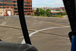
Portland Downtown Heliport is a public heliport located in the Old Town Chinatown neighborhood in the northwest section of the city of Portland, Multnomah County, Oregon, United States. It occupies the roof of a 1989 parking garage located at the intersection of NW Naito Parkway and NW Davis Street, not far from the Steel Bridge over the Willamette River.

McNary ARNG Field Heliport is a military heliport located two miles (3 km) southeast of the city of Salem in Marion County, Oregon, United States. It is located on the north east corner of Salem Municipal Airport. The heliport serves as the primary base of activity for the Oregon National Guard Army Aviation Support Facility.
Camp Rilea Heliport is a military heliport three miles (4.8 km) south of the city of Warrenton in Clatsop County, Oregon, United States.
Mahlon Sweet Field Heliport is a private heliport located 7 miles northwest of Eugene in Lane County, Oregon, United States.
Southern Oregon General Hospital Heliport is a private heliport located north of Grants Pass in Josephine County, Oregon, United States.
Myrtle Creek Municipal Heliport is a private heliport located 3 miles southeast of Myrtle Creek in Douglas County, Oregon, United States.
Rose Garden Heliport is a private heliport located in inner northeast Portland, Multnomah County, Oregon, United States.
South Hill Heliport is a private heliport located 5 miles (8.0 km) south of Salem in Marion County, Oregon, United States.
Mid-Columbia Fire & Rescue Heliport is a private heliport located 1 mile west of The Dalles in Wasco County, Oregon, USA.
Roberts Army Heliport is a U.S. Army heliport at Camp Roberts in extreme southern Monterey County, California, United States. It is located just off U.S. Route 101, four nautical miles northwest of the central business district of San Miguel, about halfway between it and the tiny community of Bradley in southern Monterey County. Roberts AHP has one helipad designated H1 with a 2,740 x 100 ft asphalt surface.
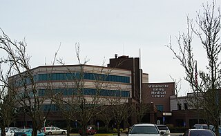
Willamette Valley Medical Center is a for-profit Level III acute care hospital in McMinnville, Oregon, United States, adjacent to the McMinnville Airport on Oregon Route 18. Opened at a different location as McMinnville Community Hospital, the four-story medical center has 60 licensed hospital beds. It is owned by Lifepoint.
Varnell Heliport is a heliport located in unincorporated Galveston County, Texas, United States. The airport is located south of League City, east of Alvin, and northwest of Santa Fe.
St. Elizabeth Health Services is a private Roman Catholic hospital in Baker City, Oregon, United States. It opened August 24, 1897 as St. Elizabeth Hospital. In 1912, a 115-bed facility was constructed at 2365 4th Street. The hospital moved to its current location on Pocahontas Road in April 1969.
Camp Edwards Heliport is a private use heliport located at Camp Edwards, a U.S. Army facility in Barnstable County, Massachusetts, United States. The airport is located three nautical miles (6 km) north of the central business district of Bourne, Massachusetts. It is owned by the Massachusetts Army National Guard.
Sabre Army Heliport is a military use heliport located at Fort Campbell, seven nautical miles (13 km) northwest of the central business district of Clarksville, in Montgomery County, Tennessee, United States. Owned by the United States Army, it has one runway designated 4/22 with a concrete surface measuring 4,451 by 109 feet.
Ferris Red Oak Muni Heliport is a city-owned public heliport in Ellis County, Texas, United States, serving the cities of Ferris, Texas and Red Oak, Texas. The heliport has no IATA or ICAO designation. The facility is alternatively known as the Ferris Red Oak Municipal Heliport.
Dallas CBD Vertiport is a city-owned public heliport/vertiport in the city of Dallas, Dallas County, Texas, United States. The facility is located at the south end of the Kay Bailey Hutchison Convention Center in the Dallas Central Business District, and is claimed to be the world's largest elevated heliport/vertiport.
DeSoto Heliport is a city-owned public heliport in DeSoto, Dallas County, Texas, United States, located 3 nautical miles (5.6 km) north of the central business district. The heliport has no IATA or ICAO designation.