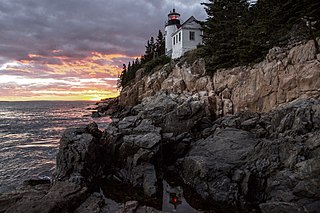
Acadia National Park is an American national park located along the mid-section of the Maine coast, southwest of Bar Harbor. The park preserves about half of Mount Desert Island, part of the Isle au Haut, the tip of the Schoodic Peninsula, and portions of 16 smaller outlying islands. It protects the natural beauty of the rocky headlands, including the highest mountains along the Atlantic coast. Acadia boasts a glaciated coastal and island landscape, an abundance of habitats, a high level of biodiversity, clean air and water, and a rich cultural heritage.

Point Pelee National Park is a national park in Essex County in southwestern Ontario, Canada where it extends into Lake Erie. The word pelée is French for 'bald'. Point Pelee consists of a peninsula of land, mainly of marsh and woodland habitats, that tapers to a sharp point as it extends into Lake Erie. Middle Island, also part of Point Pelee National Park, was acquired in 2000 and is just north of the Canada–United States border in Lake Erie. Point Pelee is the southernmost point of mainland Canada, and is located on a foundation of glacial sand, silt and gravel that bites into Lake Erie. This spit of land is slightly more than seven kilometres long by 4.5 kilometres (2.8 mi) wide at its northern base. Established in 1918, Point Pelee was the first national park in Canada to be established for conservation. It was designated as a Ramsar site on 27 May 1987.
Eastbrook is a town in Hancock County, Maine, United States. The population was 424 at the 2020 census.

China is a town in Kennebec County, Maine, United States. The population was 4,408 at the 2020 census. China is included in the Augusta, Maine micropolitan New England City and Town Area.

Moosehead Lake is a deep, coldwater lake located in Piscataquis County in Northwestern Maine. It is the second-largest lake in New England, and the largest mountain lake in the eastern United States. Situated in the mostly undeveloped Longfellow Mountains, the lake is the source of the Kennebec River. Several rural Townships border the lake. Greenville is by far the largest town on the lake, with a small downtown area that has banks, shops, and restaurants. There are over 80 islands in the lake, the largest being Sugar Island and Deer Island to the west being the second largest.

The Folsom Lake State Recreation Area surrounds Folsom Lake in the foothills of the Sierra Nevada, and is managed by the California Department of Parks and Recreation. It is located near the city of Folsom, California, about 25 miles (40 km) east of Sacramento.
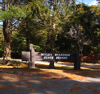
Myles Standish State Forest is a state forest located in the towns of Plymouth and Carver in southeastern Massachusetts, approximately 45 miles (70 km) south of Boston. It is the largest publicly owned recreation area in this part of Massachusetts and is managed by the Department of Conservation and Recreation (DCR).

Mooselookmeguntic Lake is located in Franklin County and Oxford County, Maine, in the United States. It is part of the Androscoggin River watershed. It is located in the western part of Maine, near the border with the state of New Hampshire and the Canadian province of Quebec. The lake is just a few miles from the Appalachian Trail.

The Presumpscot River is a 25.8-mile-long (41.5 km) river located in Cumberland County, Maine. It is the main outlet of Sebago Lake. The river provided an early transportation corridor with reliable water power for industrial development of the city of Westbrook and the village of South Windham.

Black Pond Wildlife Management Area is a 526-acre (213 ha) New York State Wildlife Management Area (WMA) that lies on the eastern shore of Lake Ontario, and at the northern limit of an unusual region of sandy barrier beaches and lagoons. Much of the barrier beach in Black Pond WMA has forested sand dunes that are about 60 feet (18 m) high; these are the highest sand dunes in the northeast United States excepting Cape Cod. Immediately north of the WMA is the 360-acre (150 ha) El Dorado Beach Preserve, which is a bird refuge owned by The Nature Conservancy. North of the outlet from Black Pond to Lake Ontario, the shoreline is a weathered, flat bedrock shelf that is "calcareous" instead of sandy.

Sandy Pond Beach Unique Area is a 76-acre (31 ha) New York State conservation area located within the eastern Lake Ontario dunes. It lies at the north end of a spit of land dividing North Sandy Pond from Lake Ontario, and is about two miles (3.2 km) north of the developed portion of Sandy Island Beach State Park. There is no road access to the area, which can be most easily reached by boat. For this reason, local residents have long referred to the beach as "Boaters' Beach". It has been managed as part of Sandy Island Beach State Park since 2011.
The Baker Branch Saint John River is a 48.0-mile-long (77.2 km) river. This river is a tributary of the Saint John River, flowing in the Maine North Woods, in Maine, in the Northeastern United States.
The Moose River is an 83-mile-long (134 km) river in Maine. Its source is in Beattie, on the Canada–United States border, which runs along the height of land between the watersheds of the Kennebec River in Maine and the Chaudière River in Quebec. From there, the river runs east through Attean Pond and Wood Pond, past the town of Moose River, then through Long Pond and Brassua Lake. The Moose River empties into Moosehead Lake, the source of the Kennebec River, in Rockwood Strip. The International Railway of Maine was built along Moose River in 1889.
The Roach River is a river in Piscataquis County, Maine. From the outlet of Third Roach Pond in Shawtown, the river runs 19.1 miles (30.7 km) west, through a chain of ponds. The Flow sequence through the ponds is from the Fourth Roach Pond through the Third Roach Pond, Second Roach Pond, and First Roach Pond to empty into Moosehead Lake, the source of the Kennebec River, in Spencer Bay. The Seventh Roach Pond drains through the Sixth Roach Pond in a separate tributary to the Third Roach Pond. No fifth Roach Pond is shown on modern maps.

Bridgton is a town in Cumberland County, Maine, United States. The population was 5,418 at the 2020 census. A resort area in Maine's Lakes Region, Bridgton is home to Bridgton Academy, a private preparatory school, and the Four on the Fourth Road Race.
Winthrop is a town in Kennebec County, Maine, United States. The population was 6,121 at the 2020 census. Winthrop's population, however, approximately doubles during the summer months as part-year residents return to seasonal camps located on the shores of Winthrop's Lakes and Ponds. A recreational area located among lakes, the town includes the villages of Winthrop and East Winthrop, and is the center of the Winthrop Lakes Region. Winthrop is included in the Augusta, Maine Micropolitan New England City and Town Area.
The Belgrade Lakes are a chain of lakes around Belgrade, Maine. The flow sequence is from East Pond to North Pond to Great Pond to Long Pond to Messalonskee Lake and thence via Messalonskee Stream to the Kennebec River at Waterville. The lakes have long been an important resort area for fishing, boating, and swimming; and shoreline development includes residences for individuals employed in the cities of Waterville and Augusta.
Spencer Lake extends southward from Fish Pond in Hobbstown township into Maine township 3, range 5. The north end of the lake receives drainage from Whipple Bog, Whipple Pond, Hall Pond, Toby Pond, and Chub Pond through Fish Pond. The south end of the lake overflows through Little Spencer Stream and thence Spencer Stream 6 miles (9.7 km) to the Dead River 14 miles (23 km) upstream of the confluence with the Kennebec River at The Forks. The lake supports a native population of lake trout and brook trout, and has been stocked with land-locked Atlantic salmon. There is a boat launch area at the north end of the lake accessible from a 2-mile (3.2 km) gravel road 11 miles (18 km) west off U.S. Route 201 at Parlin Pond.
A chain of three Jo-Mary Lakes along the border of Penobscot County and Piscataquis County drain into the Pemadumcook Chain of Lakes in the North Maine Woods. The flow sequence is from Upper Jo-Mary Lake into Middle Jo-Mary Lake and then through Lower Jo-Mary Lake into Pemadumcook Lake.
Threemile Run is a tributary of the Tohickon Creek in Bucks County, Pennsylvania in the United States and is part of the Delaware River watershed.
