This article has an unclear citation style.Learn how and when to remove this template message) (January 2017) ( |
Coordinates: 36°27′N8°40′E / 36.45°N 8.66°E Touccabeur, known in ancient times as Thuccabora, is a railway town and archaeological site in northern Tunisia. It is located in the Medjerda valley, outside of Bou Salem. Touccabeur is located in the Medjerda valley at 36.45N, 8.66E, outside of Bou Salem. [1]
A geographic coordinate system is a coordinate system that enables every location on Earth to be specified by a set of numbers, letters or symbols. The coordinates are often chosen such that one of the numbers represents a vertical position and two or three of the numbers represent a horizontal position; alternatively, a geographic position may be expressed in a combined three-dimensional Cartesian vector. A common choice of coordinates is latitude, longitude and elevation. To specify a location on a plane requires a map projection.
A railway town, or railroad town, is a settlement that originated or was greatly developed because of a railway station or junction at its site.
Tunisia (officially the Republic of Tunisia) is a country in the Maghreb region of North Africa, covering 165,000 square kilometres. Its northernmost point, Cape Angela, is the northernmost point on the African continent. It is bordered by Algeria to the west and southwest, Libya to the southeast, and the Mediterranean Sea to the north and east. Tunisia's population was 11.435 million in 2017. Tunisia's name is derived from its capital city, Tunis, which is located on its northeast coast.
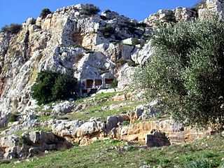
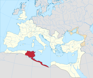
In antiquity, Thuccabora was a Roman – Berber civitas in the province of Africa Proconsularis. The stone ruins of the city lie near the modern town, and include inscriptions from the reign of Commodus. [2]
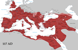
The Roman Empire was the post-Roman Republic period of the ancient Roman civilization. It had a government headed by emperors and large territorial holdings around the Mediterranean Sea in Europe, North Africa, and West Asia. From the constitutional reforms of Augustus to the military anarchy of the third century, the Empire was a principate ruled from the city of Rome. The Roman Empire was then divided between a Western Roman Empire, based in Milan and later Ravenna, and an Eastern Roman Empire, based in Nicomedia and later Constantinople, and it was ruled by multiple emperors.
Berbers, or Amazighs are an ethnic group of several nations indigenous to North Africa.
In the history of Rome, the Latin term civitas, according to Cicero in the time of the late Roman Republic, was the social body of the cives, or citizens, united by law. It is the law that binds them together, giving them responsibilities (munera) on the one hand and rights of citizenship on the other. The agreement (concilium) has a life of its own, creating a res publica or "public entity", into which individuals are born or accepted, and from which they die or are ejected. The civitas is not just the collective body of all the citizens, it is the contract binding them all together, because each of them is a civis.
Inscriptions from the reign of Commodus. [3] During the Roman Empire Thuccabora was the seat of an ancient bishopric which survives today as a titular see of the Roman Catholic Church. [4]
Commodus, born Lucius Aurelius Commodus and died Lucius Aelius Aurelius Commodus, was Roman emperor with his father Marcus Aurelius from 177 to his father's death in 180, and solely until 192.
A cathedra or bishop's throne is the seat of a bishop. It is a symbol of the bishop's teaching authority in the Catholic Church, the Orthodox Church, and the Anglican Communion churches. Cathedra is the Latin word for a chair with armrests, and it appears in early Christian literature in the phrase "cathedrae apostolorum", indicating authority derived directly from the apostles; its Roman connotations of authority reserved for the Emperor were later adopted by bishops after the 4th century. A church into which a bishop's official cathedra is installed is called a cathedral.
A titular see in various churches is an episcopal see of a former diocese that no longer functions, sometimes called a "dead diocese".
Tifinagh is an abjad script used to write the Tamazight languages.
Cirta, also known by various other names in antiquity, was the ancient Berber and Roman settlement which later became Constantine, Algeria. Cirta was the capital city of the Berber kingdom of Numidia; its strategically important port city was Russicada. Although Numidia was a key ally of the ancient Roman Republic during the Punic Wars, Cirta was subject to Roman invasions during the 2nd and 1st centuries BC. Eventually it fell under Roman dominion during the time of Julius Caesar. Cirta was then repopulated with Roman colonists by Caesar and Augustus and was surrounded by a "confederation of free Roman cities" such as Tiddis, Cuicul, and Milevum. The city was destroyed in the beginning of the 4th century and was rebuilt by the Roman emperor Constantine the Great, who gave his name to the newly constructed city, Constantine. The Vandals damaged Cirta, but emperor Justinian I reconquered and improved the Roman city. It declined in importance after the Muslim invasions, but a small community continued at the site for several centuries. Its ruins are now an archaeological site.
The Medjerda River, the classical Bagrada, is a river in North Africa flowing from northeast Algeria through Tunisia before emptying into the Gulf of Tunis and Lake of Tunis. With a length of 450 km (280 mi), it is the longest river of Tunisia. It is also known as the Wadi Majardah or Mejerha.
Testour is a small town located in the north of Tunisia. The town is perched on the hills of Medjerda Valley, 20 km (12 mi) south-west of Medjez-el-Bab, the crossroads between Tunis, Béja, and the north of Tunisia. It was known during the Roman period, as Tichilla, which means the green grass as it is situated in the mouth of Siliana valley. It was rebuilt by Muslim and Jewish refugees from Andalusia who gave it a distinctive character in building and layout. Today it is a popular pilgrimage for Jews who visit Rabbi Fraji Chawat's tomb.
Petite Kabylie or Petite Kabylia is a natural region in the mountainous area of northern Algeria. The Petite Kabylie is part of the greater Kabylie region.
Bou Saada is a town and municipality in M'Sila Province, Algeria, situated 245 km south of Algiers. As Arena it was the site of a city and bishopric in Roman Africa, now a Catholic titular see. The municipal population was estimated at 134,000 in 2008.
The Ifranids, also called Banu Ifran, Ifran, or the children of the Ifran, were a Zenata Berber tribe prominent in the history of pre-Islamic and early Islamic North Africa. In the 8th century, they established a kingdom in Central Maghreb, Algeria with Tlemcen as its capital.
Boumedfaa a town in northern Algeria.
Djinet, the classical Cissi, is a port town and commune in the Bordj Menaïel District of Boumerdès Province, Algeria, east of the mouth of the Isser River and around Cape Djinet. As of 2008, the population of the municipality is 21,966.
Bou Salem (بوسالم) is a town and commune in the Jendouba Governorate, Tunisia. As of 2004 it had a population of 20,098. by 2014 this had grown 35,192.
Jean-Marie Lassère was a 20th-century French historian of the Roman world. He was professor of Roman history at the Paul Valéry University, Montpellier III. A specialist in Roman Africa, he was also an epigrapher, author of an important textbook.
Djebba, also known as Thigibba Bure and Thigibba, is a town and an ancient archaeological site is located in Bājah, Tunisia. Djebba is an archaeological/prehistoric site in Tunisia located at latitude: 36°28'32.45" longitude: 9°4'53.54" in the Béja Governorate of northwestern Tunisia. The estimate terrain elevation above seal level is 355 metres located below the slopes of Djebel Gorra, 700 meters above sea level. Djebba also has a national park, which is the subject of a development project
Chaouach is a village in Béja Governorate, Tunisia. It is located between Béja and Tunis and north of Medjez-El-Bab. The area sits in a valley high up the sides of the watershed of the Medjerda river. In antiquity, it was a Roman Catholic diocese.
Bordj Toumi or Borj Toumi is a town in Tunisia located at 36°45'33"N 9°43'3"E It is a railway town on the Medjerda river. The town is near Dor el Gabsi west of Tunis and at n elevation of 52 meters above sea level.
Sidi-Meskin is a railway town, and archaeological site in Gouvernorat of Jendouba, Northern Tunisia. It is located in the Medjerda valley at 36.45N, 8.66E, outside of Bou Salem and is nearby to Djendouba, Mechtat el Anad and Djebel Bou Rbah. The town is located at an elevation of 430 meters above sea level, and has a mosque and railroad station.
Ladbech is a railway town and archaeological site in northern Tunisia. It is located in the Medjerda valley, outside of Bou Salem.
Toukabeur is a town in Béja Governorate, Tunisia located at 36°42′32″N, 9°31′16″E. Toukabeur is in the Medjerda River valley, and 2 km west of Chaouach (Suas) and 7 kilometers northwest of Majaz al Bab,(Membressa). Its postal code is 9024.
Henchir-Aïn-Dourat, also known as Ad-Duwayrat or Henchir Durat, is a former Roman–Berber civitas and archaeological site in Tunisia. It is located at 36.767496n, 9.524142e, in the hills just north of Toukabeur and 15.3 km from Majāz al Bāb. It was an ancient Catholic diocese.
Uzuncaburç is an archaeological site in Mersin Province, Turkey, containing the remnants of the ancient city of Diokaisareia or Diocaesarea.