IONA is an acronym suggested in 1980 by Sir John Biggs-Davison to refer to a loose linkage of the Channel Islands, Great Britain, Ireland, and the Isle of Man, similar to the present day British–Irish Council. Its intended purpose was as a more politically acceptable alternative to the British Isles, which is disliked by some people in Ireland.
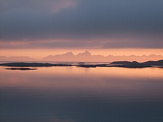
The Norwegian Sea is a marginal sea, grouped with either the Atlantic Ocean or the Arctic Ocean, northwest of Norway between the North Sea and the Greenland Sea, adjoining the Barents Sea to the northeast. In the southwest, it is separated from the Atlantic Ocean by a submarine ridge running between Iceland and the Faroe Islands. To the north, the Jan Mayen Ridge separates it from the Greenland Sea.

The history of Greenland is a history of life under extreme Arctic conditions: currently, an ice sheet covers about eighty percent of the island, restricting human activity largely to the coasts. The first humans are thought to have arrived in Greenland around 2500 BCE. Their descendants apparently died out and were succeeded by several other groups migrating from continental North America. There has been no evidence discovered that Greenland was known to Norsemen until the ninth century CE, when Norse Icelandic explorers settled on its southwestern coast. The ancestors of the Greenlandic Inuit who live there today appear to have migrated there later, around the year 1200, from northwestern Greenland.

Iceland is an island country at the confluence of the North Atlantic and Arctic oceans, east of Greenland and immediately south of the Arctic Circle, atop the constructive boundary of the northern Mid-Atlantic Ridge. The island country is the world's 18th largest in area and one of the most sparsely populated. It is the westernmost European country when not including Greenland and has more land covered by glaciers than continental Europe. Its total size is 103,125 km2 (39,817 sq mi) and possesses an exclusive economic zone of 751,345 km2 (290,096 sq mi).

In biogeography, a land bridge is an isthmus or wider land connection between otherwise separate areas, over which animals and plants are able to cross and colonize new lands. A land bridge can be created by marine regression, in which sea levels fall, exposing shallow, previously submerged sections of continental shelf; or when new land is created by plate tectonics; or occasionally when the sea floor rises due to post-glacial rebound after an ice age.
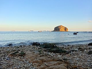
An islet is a very small, often unnamed island. Most definitions are not precise, but some suggest that an islet has little or no vegetation and cannot support human habitation. It may be made of rock, sand and/or hard coral; may be permanent or tidal ; and may exist in the sea, lakes, rivers or any other sizeable bodies of water.

Thule is the most northerly location mentioned in ancient Greek and Roman literature and cartography. Modern interpretations have included Orkney, Shetland, Northern Scotland, the island of Saaremaa (Ösel) in Estonia, and the Norwegian island of Smøla.
Mainland is defined as "relating to or forming the main part of a country or continent, not including the islands around it [regardless of status under territorial jurisdiction by an entity]." The term is often politically, economically and/or demographically more significant than politically associated remote territories, such as exclaves or oceanic islands situated outside the continental shelf.
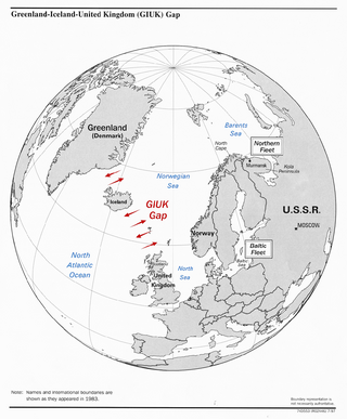
The GIUK gap is an area in the northern Atlantic Ocean that forms a naval choke point. Its name is an acronym for Greenland, Iceland, and the United Kingdom, the gap being the two stretches of open ocean among these three landmasses. It separates the Norwegian Sea and the North Sea from the open Atlantic Ocean. The term is typically used in relation to military topics. The area has for some nations been considered strategically important since the beginning of the 20th century.

Baffin Bay, located between Baffin Island and the west coast of Greenland, is defined by the International Hydrographic Organization as a marginal sea of the Arctic Ocean. It is sometimes considered a sea of the North Atlantic Ocean. It is connected to the Atlantic via Davis Strait and the Labrador Sea. The narrower Nares Strait connects Baffin Bay with the Arctic Ocean. The bay is not navigable most of the year because of the ice cover and high density of floating ice and icebergs in the open areas. However, a polynya of about 80,000 km2 (31,000 sq mi), known as the North Water, opens in summer on the north near Smith Sound. Most of the aquatic life of the bay is concentrated near that region.
Danish overseas colonies and Dano-Norwegian colonies were the colonies that Denmark–Norway possessed from 1536 until 1953. At its apex, the colonies spanned four continents: Africa, Asia, Europe, and North America.
The International Island Games Association (IIGA) is the organising body for the Island Games, a friendly biennial multi-sport competition between teams from several European islands and other small territories. The IIGA liaises with the member island associations and with sponsors of the games. It investigates whether islands wanting to join fit the membership criteria.

Nares Strait is a waterway between Ellesmere Island and Greenland that connects the northern part of Baffin Bay in the Atlantic Ocean with the Lincoln Sea in the Arctic Ocean. From south to north, the strait includes Smith Sound, Kane Basin, Kennedy Channel, Hall Basin and Robeson Channel. Nares Strait has a nearly permanent current from the north, powered by the Beaufort Gyre, making it harder to traverse for ships coming from the south.

UTC−01:00 is an identifier for a time offset from UTC of −01:00.

The Danish Realm, officially the Kingdom of Denmark, refers to the area over which the monarch of Denmark is head of state. It consists of metropolitan Denmark—the kingdom's territory in continental Europe and sometimes called "Denmark proper" —and the realm's two autonomous regions: the Faroe Islands in the North Atlantic and Greenland in North America. The relationship between the three parts of the Kingdom is also known as The unity of the Realm.

The Arctic Ocean is the smallest and shallowest of the world's five major oceans. It spans an area of approximately 14,060,000 km2 (5,430,000 sq mi) and is known as one of the coldest of oceans. The International Hydrographic Organization (IHO) recognizes it as an ocean, although some oceanographers call it the Arctic Mediterranean Sea. It has also been described as an estuary of the Atlantic Ocean. It is also seen as the northernmost part of the all-encompassing World Ocean.

Arctic exploration is the physical exploration of the Arctic region of the Earth. It refers to the historical period during which mankind has explored the region north of the Arctic Circle. Historical records suggest that humankind have explored the northern extremes since 325 BC, when the ancient Greek sailor Pytheas reached a frozen sea while attempting to find a source of the metal tin. Dangerous oceans and poor weather conditions often fetter explorers attempting to reach polar regions, and journeying through these perils by sight, boat, and foot has proven difficult.

Herjolfsnes was a Norse settlement in Greenland, 50 km northwest of Cape Farewell. It was established by Herjolf Bardsson in the late 10th century and is believed to have lasted some 500 years. The fate of its inhabitants, along with all the other Norse Greenlanders, is unknown. The site is known today for having yielded remarkably well-preserved medieval garments, excavated by Danish archaeologist Poul Nörlund in 1921. Its name roughly translates as Herjolf's Point or Cape.

(Kongelige) Grønlandske Handels Plads is a waterfront area at the end of Strandgade in the northwestern corner of the Christianshavn neighbourhood of Copenhagen, Denmark. The area is bounded by the Trangraven canal to the north, Christianshavn Canal to the east, Krøyers Plads to the south and the main harbor to the west. The waterfront is also known as Nordatlantens Brygge. It is named for the Royal Greenland Trading Department and was for more than 200 years a hub for Danish trade on Greenland, Iceland and the Faroe Islands. The most notable building is North Atlantic House, an 18th-century warehouse now used as a cultural centre for the North Atlantic area.


