Lower New York Bay is a section of New York Bay south of the Narrows. The eastern end of the Bay is marked by two spits of land, Sandy Hook, New Jersey, and Rockaway, Queens. The waterway between the spits connects the Bay to the Atlantic Ocean at the New York Bight. Traversing the floor of the Bay southeasterly from the Narrows to the Bight and beyond is Hudson Canyon.

The Jersey Shore, commonly referred to locally as simply the Shore, is the coastal region of the U.S. state of New Jersey. Geographically, the term encompasses about 141 miles (227 km) of oceanfront bordering the Atlantic Ocean, from Perth Amboy in the north to Cape May Point in the south. The region includes Middlesex, Monmouth, Ocean, Atlantic, and Cape May counties, which are in the central and southern parts of the state. Located in the center of the Northeast Megalopolis, the northern half of the shore region is part of the New York metropolitan area, while the southern half of the shore region is part of the Philadelphia metropolitan area, also known as the Delaware Valley. The Jersey Shore hosts the highest concentration of oceanside boardwalks in the United States.

The New York–New Jersey Harbor Estuary, also known as the Hudson-Raritan Estuary, is in the northeastern states of New Jersey and New York on the East Coast of the United States. The system of waterways of the Port of New York and New Jersey forms one of the most intricate natural harbors in the world and one of the busiest ports of the United States. The harbor opens onto the New York Bight in the Atlantic Ocean to the southeast and Long Island Sound to the northeast.

The Cohansey River, also called Cohansey Creek, is a 30.6-mile-long (49.2 km) river in southern New Jersey of the United States. It drains approximately 108 square miles (280 km2) of rural agricultural and forested lowlands on the north shore of Delaware Bay.

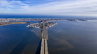
Long Beach Island is a barrier island and summer colony along the Atlantic Ocean coast of Ocean County, New Jersey, United States, on the Jersey Shore. Aligned north to south, the northern portion generally has more expensive low-density housing, whereas the southern portion possesses higher-density housing and considerable commercial development. Long Beach Island is 1-2 miles away from Mainland New Jersey. The primary industries include tourism, fishing, and real estate. The only access point to the island by land is a single causeway. The island is the southernmost point of the New York Metropolitan Area.

Sucia Island is located 2.5 miles (4.0 km) north of Orcas Island in the San Juan Islands, San Juan County, Washington, United States. It is the largest of an archipelago of ten islands including Sucia Island, Little Sucia, Ewing, Justice, Herndon, the Cluster Islands islets, and several smaller, unnamed islands. The group of islands is about 2.5 miles (4.0 km) in length and just short of a half mile wide. Sucia island is roughly the shape of a hand. The total land area of all islands is 2.74 km2. The main island of Sucia Island by itself is 2.259 km2. There was a permanent population of four persons as of the 2000 census, all on Sucia Island. Sucia Island State Park is a Washington State Marine Park.

Hoffman Island is an 11-acre (4.5 ha) artificial island in the Lower New York Bay, off the South Beach of Staten Island, New York City. A smaller, 4-acre (1.6 ha) artificial island, Swinburne Island, lies immediately to the south. Created in 1873 upon the Orchard Shoal by the addition of landfill, the island is named for former New York City mayor (1866–1868) and New York Governor (1869–1871) John Thompson Hoffman.

Discovery Island Marine Provincial Park is a provincial park located about two nautical miles east of Oak Bay on the coast of British Columbia, Canada. It is about one mile (1.6 km) long and one-half mile (0.80 km) wide and looks out into the Strait of Juan de Fuca.
Island Beach State Park is a New Jersey state park located just south of Seaside Park on the Barnegat Peninsula in Berkeley Township, Ocean County, New Jersey, United States. The park is operated and maintained by the New Jersey Division of Parks and Forestry. Most of the park encompasses the former borough of Island Beach.

Smuggler Cove Marine Provincial Park is a provincial park in British Columbia, Canada located approximately 16 kilometres (9.9 mi) west of Sechelt, a city on the Sunshine Coast.
Brigantine Island is an island off the Atlantic Ocean coast of New Jersey, located northeast of Atlantic City. It is 6 miles (9.7 km) long. The resort community of Brigantine is located on the island.
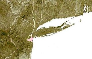
The Barnegat Peninsula, also known as the Island Beach Peninsula or Barnegat Bay Island and colloquially as "the barrier island", is a 20-mile (32 km) long, narrow barrier peninsula located on the Jersey Shore in Ocean County, New Jersey, United States, that divides the Barnegat Bay from the Atlantic Ocean. It is a vacation destination and summer colony area and is heavily dependent on tourism, real estate and fishing.

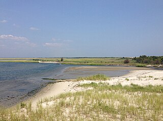
Barnegat Inlet is a small inlet connecting the Barnegat Bay with the Atlantic Ocean in Ocean County, New Jersey. It separates Island Beach State Park and the Barnegat Peninsula from Long Beach Island. The Barnegat Lighthouse sits at the northern end of Long Beach Island along the inlet.

Engleside Hotel was one of the most decorative and beautiful Victorian hotels that once stood on Engleside Avenue in Beach Haven, New Jersey, United States. It was completed by the start of the 1876 summer season, under the leadership of Robert Engle, and it quickly became one of the most popular resorts on Long Beach Island, along with the Baldwin Hotel located nearby.
The New Jersey Coastal Heritage Trail Route extends along eastern and southern coast of New Jersey for nearly 300 miles (480 km). It travels along the Raritan Bay from Perth Amboy to Sandy Hook, along Jersey Shore at the Atlantic Ocean to Cape May, and along the Delaware Bay to the Delaware Memorial Bridge. The trail encompasses a variety of New Jersey state parks along with facilities under the jurisdiction of the National Park Service.
Island Beach was a borough that existed in Ocean County, New Jersey, United States, from 1933 to 1965.
Bertrand Island Amusement Park was located on Lake Hopatcong, New Jersey in the Borough of Mount Arlington, New Jersey. It was actually located on a narrow finger-shaped peninsula, surrounded by water on three sides, that jutted into Lake Hopatcong.
Short Beach Island, Short Beach or Tucker's Island was a barrier island located on the Jersey Shore of the Atlantic Ocean. Little Beach is a remnant of Short Beach; the northern remnant was encroached upon and attached to Long Beach Island before succumbing to erosion.
Cranberry Inlet was an inlet connecting Barnegat Bay with the Atlantic Ocean in Ocean County, New Jersey. It has been closed since 1812.
Brigantine Inlet is an inlet connecting Little Bay with the Atlantic Ocean in Atlantic County, New Jersey.