Related Research Articles

Captain George Vancouver was a British Royal Navy officer best known for his 1791–1795 expedition, which explored and charted North America's northwestern Pacific Coast regions, including the coasts of what are now the Canadian province of British Columbia as well as the US states of Alaska, Washington, Oregon, and California. The expedition also explored the Hawaiian Islands and the southwest coast of Australia.

Douglas Island is a tidal island in the U.S. state of Alaska. It is part of the city and borough of Juneau, just west of downtown Juneau and east of Admiralty Island. It is separated from mainland Juneau by the Gastineau Channel, and contains the communities of Douglas and West Juneau.

The Alexander Archipelago is a 300-mile (480 km) long archipelago in North America lying off the southeastern coast of Alaska. It contains about 1,100 islands, the tops of submerged coastal mountains that rise steeply from the Pacific Ocean. Deep channels and fjords separate the islands and cut them off from the mainland. The islands shelter the northern part of the Inside Passage as it winds its way among them.
Frederick Sound is a passage of water in the Alexander Archipelago in Southeast Alaska that separates Kupreanof Island to the south from Admiralty Island in the north.
Admiralty Island is an island in the Alexander Archipelago in Southeast Alaska, at 57°44′N134°20′W. It is 145 km (90 mi) long and 56 km (35 mi) wide with an area of 4,264.1 km2 (1,646.4 sq mi), making it the seventh-largest island in the United States and the 132nd largest island in the world. It is one of the ABC islands in Alaska. The island is nearly cut in two by the Seymour Canal; to its east is the long, narrow Glass Peninsula. Most of Admiralty Island—955,747 acres (3,868 km2)—is protected as the Admiralty Island National Monument administered by the Tongass National Forest. The Kootznoowoo Wilderness encompasses vast stands of old-growth temperate rainforest. These forests provide some of the best habitat available to species such as brown bears, bald eagles, and Sitka black-tailed deer.

Stephens Passage is a channel in the Alexander Archipelago in the southeastern region of the U.S. state of Alaska. It runs between Admiralty Island to the west and the Alaska mainland and Douglas Island to the east, and is about 170 km (105 mi) long. Juneau, the capital of Alaska, is near the north end, on Gastineau Channel.

New Eddystone Rock an Alaskan island located in Behm Canal, about 40 miles (64 km) east of Ketchikan. It is a pillar of basalt.

Lincoln Island is a wooded island in Lynn Canal in Alaska, United States. Located at 58°29′41″N134°59′40″W, the island is one kilometer northwest of larger Shelter Island and some 200 meters southeast of smaller Ralston Island. It is part of the Juneau City and Borough. The first European to sight the island was Joseph Whidbey, master of HMS Discovery during George Vancouver's 1791–1795 expedition, in 1794. It was named in 1868 by Commander R. W. Meade, USN, presumably for Abraham Lincoln.
The Vancouver Expedition (1791–1795) was a four-and-a-half-year voyage of exploration and diplomacy, commanded by Captain George Vancouver of the Royal Navy. The British expedition circumnavigated the globe and made contact with five continents. The expedition at various times included between two and four vessels, and up to 153 men, all but 6 of whom returned home safely.

Holkham Bay is a bay in the U.S. state of Alaska. It connects Tracy Arm and Endicott Arm on its east to Stephens Passage on its west.
The temperate rainforests of Admiralty Island's Kootznoowoo Wilderness are a unique environment among the 5,700,000 acres (2,300,000 ha) of federally-protected wilderness in Southeast Alaska.
Fillmore Island is an island in Southeast Alaska, United States. The island lies between Fillmore Inlet and Pearse Canal. The island was charted by George Vancouver in 1793, who sailed around it and proved its insular nature. It was named in 1885 by the United States Coast and Geodetic Survey after Ensign John Hudson Fillmore, USN.
Bell Island is an island in the Alexander Archipelago in Southeast Alaska, United States. It is 14 kilometres (8.7 mi) long, lying in Behm Canal, north of Revillagigedo Island. George Vancouver first visited the island on August 12, 1793, in the evening dining on its south coast. He suspected that it was an island, but this was not proven until later in the same month, when Joseph Whidbey, master of HMS Discovery, charted its entire coastline. Vancouver later named it "Bell's Island" after one of his crew, Midshipman Bell.
Affleck Canal is an inlet in Southeast Alaska, United States It extends 32 kilometres (20 mi) north from Sumner Strait, nearly cutting Kuiu Island in two. It was first charted in 1793 by Joseph Whidbey, master of HMS Discovery during George Vancouver's 1791–1795 expedition. Vancouver named it for Admiral Philip Affleck, RN.
Favorite Channel is a channel in Southeast Alaska, northwest of Juneau, Alaska, United States. It is 25 kilometres (16 mi) long, extending northwest from Stephens Passage to Lynn Canal, separating Lincoln and Shelter islands from the mainland to the east. It was named in 1880 by U.S. Navy officers after the 80-foot (24 m) steamboat Favorite, which was chartered by the Navy for surveying work in Alaska, later being used to carry out trading and fishing for the herring plant at Killisnoo. The first European to traverse and chart the channel was Joseph Whidbey, master of HMS Discovery during George Vancouver's 1791–95 expedition, in 1794.

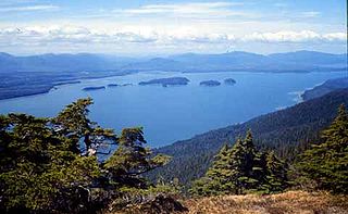
Seymour Canal is an inlet penetrating deep into the southeastern part of Admiralty Island, Southeast Alaska, United States. The inlet was first charted in 1794 by Joseph Whidbey, master of HMS Discovery during George Vancouver's 1791–95 expedition. Vancouver later named it "Seymour's Channel". Two large islands are located within it: Swan Island to the north, and Tiedeman Island just to its south.

The Glass Peninsula is a peninsula extending southeast from Admiralty Island, between Seymour Canal and Stephens Passage, Southeast Alaska, United States. It was named by the United States Coast and Geodetic Survey for United States Navy Commander Henry Glass, who had made surveys in the area in 1881. It was first charted in 1794 by Joseph Whidbey, master of HMS Discovery, during George Vancouver's 1791–1795 expedition.
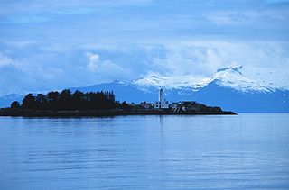
Swan Island is an island in the Alexander Archipelago, east of Admiralty Island, near the head of Seymour Canal, Southeast Alaska, United States. To its south is Tiedeman Island. It was named in 1890 by Lieutenant Commander Mansfield of the United States Navy. The first European to discover and chart the island was Joseph Whidbey, master of HMS Discovery during George Vancouver's 1791–1795 expedition, in 1794.
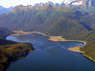
Hood Bay, also known as Hoods Bay and Hootz Bay, is an inlet in Alaska, United States. It is situated on the western shore of Admiralty Island in the Alexander Archipelago in Southeast Alaska. Hood Bay is located in the Hoonah–Angoon Census Area 4 miles (6.4 km) south of Angoon, Alaska, and is 2 miles (3.2 km) wide.
References
- ↑ U.S. Geological Survey Geographic Names Information System: Tiedeman Island
- ↑ Vancouver, George, and John Vancouver (1801). A voyage of discovery to the North Pacific ocean, and round the world. London: J. Stockdale.
{{cite book}}: CS1 maint: multiple names: authors list (link) - ↑ Iain J. Stenhouse. "Bald Eagle (Haliaeetus leucocephalus alascanus)" (PDF). Conservationgateway.org. Retrieved December 6, 2021.
- ↑ "Appendix D : Research Natural Areas" (PDF). Fs.usda.gov. Retrieved December 6, 2021.
57°49′34″N134°09′19″W / 57.82611°N 134.15528°W
| | This article about a location in the Hoonah-Angoon Census Area, Alaska is a stub. You can help Wikipedia by expanding it. |